- Maryland Route 675
-
Maryland Route 675
Route information Maintained by MDSHA MD 675 Length: 3.39 mi[1] (5.46 km) South end:  US 13 south of Princess Anne
Major
junctions: MD 388 in Princess Anne
 MD 362 in Princess Anne
 MD 822 in Princess Anne
 MD 529 in Princess Anne
North end: US 13 north of Princess AnneMD 675B Length: 2.09 mi[2] (3.36 km) South end: US 13 south of DelmarNorth end: 
 DE-MD 54 in Delmar
Location Counties: Somerset, Wicomico Highway system Maryland highway system
Interstate • US • State • Minor • Former • Turnpikes←  MD 674
MD 677  →
→Maryland Route 675 (MD 675) is a collection of state highways in the U.S. state of Maryland. These two highways are sections of old alignment of U.S. Route 13 (US 13) in Princess Anne in Somerset County and Delmar in northern Wicomico County. MD 675 was designated after US 13 bypassed Princess Anne in the late 1950s. MD 675B was assigned several years after US 13 bypassed Delmar in the mid 1950s. MD 675A existed in Pocomoke City before it was replaced by US 13 Business in the mid 1990s.
Contents
Route description
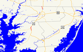
MD 675, which is known as Somerset Avenue, runs 3.39 miles (5.46 km) through Princess Anne between intersections with US 13 on the south and north sides of the town in Somerset County. MD 675B, which is signed as MD 675 as known as Bi-State Boulevard, runs 2.09 miles (3.36 km) within northern Wicomico County from US 13 north of Salisbury north to DE-MD 54 at the Delaware state line in the twin towns of Delmar, Maryland and Delmar, Delaware.
MD 675
MD 675 begins at a directional intersection with US 13 (Ocean Highway) south of Princess Anne. The 0.07-mile (0.11 km) ramp from MD 675 south to US 13 is designated MD 675D. There is no direct access from US 13 south to MD 675 north. MD 675 heads north into the town of Princess Anne, closely paralleling Norfolk Southern Railway's Delmarva Secondary rail line through a residential area. At Park Drive, the state highway veers away from the railroad and into the Princess Anne Historic District. Within the downtown area, MD 675 intersects MD 388 (Antioch Avenue), Prince William Street, which leads to the Teackle Mansion and MD 363, and Dr. William P. Hytche Boulevard, which is unsigned MD 918 and heads east toward the University of Maryland Eastern Shore.[1][3]
MD 675 crosses the Manokin River into a residential neighborhood that contains Manokin Presbyterian Church and Washington High School. The state highway intersects MD 362 (Mt. Vernon Road) and MD 822 (UMES Boulevard), which connects US 13 to the university, before leaving the town limits of Princess Anne. MD 529 (Loretto Road) splits to the east before MD 675 reaches its northern terminus at ramps to and from northbound US 13 adjacent to the rail line. There is no access from MD 675 to and from southbound US 13; those movements can be completed via MD 822.[1][3]
MD 675B
MD 675B begins at an intersection with US 13 (Ocean Highway) north of Salisbury. The state highway heads west from the perpendicular intersection, then turns north onto two-lane Bi-State Boulevard, passing through a mix of farmland, forest, and residences. At Walnut Street, MD 675B enters the town of Delmar, Maryland. The state highway passes through a residential area, cutting northwest through the street grid until the highway reaches its northern terminus at DE-MD 54 (State Street), which runs atop the Delaware state line. Bi-State Boulevard continues north into the town of Delmar, Delaware.[2][4]
History
MD 675
MD 675 between Park Drive—which intersects Old Princess Anne Road, the original alignment of US 13 from Princess Anne to Westover—and MD 529 is the original alignment of US 13. The state highway was paved south of downtown Princess Anne toward Westover in 1911 and north of downtown toward Salisbury in 1914.[5] MD 675 north of MD 529 was constructed in 1933 as part of a relocation of US 13 between Princess Anne and Fruitland to bypass the circuitous route via Loretto Road and Allen Road and to eliminate two railroad crossings.[6][7] MD 675 south of Park Drive was constructed as part of a similar relocation between Princess Anne and Westover in 1935.[7][8] US 13's present bypass of Princess Anne was constructed between 1957 and 1959.[9][10] MD 675 was marked through Princess Anne by 1978.[11]
MD 675A
MD 675A was a section of MD 675 passing through Pocomoke City in Worcester County and West Pocomoke in Somerset County. The state highway was designated after the completion of US 13's bypass of Pocomoke City around 1963.[12] MD 675 was marked by 1975.[13] The state highway followed what is now US 13 Business, which was assigned in 1994.[14]
MD 675B
MD 675B is the original alignment of US 13 through Delmar. The highway was paved as a state-aid road by 1921 and rebuilt as a state road in 1923.[15][16] US 13's present bypass of Delmar was completed in 1954 concurrent with the adjacent section of US 13 in Delaware bypassing Laurel and Seaford.[17][18] MD 675B was part of US 13 Alternate between 1954 and 1957.[18][19] MD 675B was marked through Delmar by 1983.[20]
Future
There are plans to construct a roundabout at the intersection of MD 675 and MD 822 in Princess Anne.[21]
Junction list
MD 675
The entire route is in Princess Anne, Somerset County.
Mile[1] Destinations Notes 0.00 US 13 (Ocean Highway) – Pocomoke City, NorfolkSouthern terminus; ramp from MD 675 south to US 13 is unsigned MD 675D; no access from US 13 south to MD 675 north 1.32 MD 388 east (Antioch Avenue)1.61  MD 918 east (Dr William P. Hytche Boulevard) – University of Maryland Eastern Shore
MD 918 is unsigned 2.22 MD 362 west (Mt. Vernon Road) – Mount Vernon2.59 MD 822 (UMES Boulevard) – University of Maryland Eastern Shore2.81 MD 529 north (Loretto Road)3.39 US 13 (Ocean Highway) – SalisburyNorthern terminus; no access to and from US 13 south 1.000 mi = 1.609 km; 1.000 km = 0.621 mi MD 675B
The entire route is in Delmar in Wicomico County.
Mile[2] Destinations Notes 0.00 US 13 (Ocean Highway) – SalisburySouthern terminus 2.09 DE-MD 54 (State Street) – Mardela Springs, Gumboro, DENorthern terminus; Delaware state line Bi-State Boulevard north 1.000 mi = 1.609 km; 1.000 km = 0.621 mi References
- ^ a b c d "Highway Location Reference: Somerset County" (PDF). Maryland State Highway Administration. 2009. http://www.marylandroads.com/Location/2009_SOMERSET.pdf. Retrieved 2010-10-21.
- ^ a b c "Highway Location Reference: Wicomico County" (PDF). Maryland State Highway Administration. 2009. http://www.marylandroads.com/Location/2009_WICOMICO.pdf. Retrieved 2010-10-21.
- ^ a b Google, Inc. Google Maps – Maryland Route 675 (Map). Cartography by Google, Inc. http://maps.google.com/maps?f=d&source=s_d&saddr=MD-675+N%2FSomerset+Ave&daddr=MD-675+N%2FSomerset+Ave&hl=en&geocode=FbagRgIdlxB9-w%3BFVFXRwId-xF9-w&mra=ls&sll=38.183739,-75.69056&sspn=0.001935,0.004823&ie=UTF8&t=h&z=13. Retrieved 2010-10-21.
- ^ Google, Inc. Google Maps – Maryland Route 675B (Map). Cartography by Google, Inc. http://maps.google.com/maps?f=d&source=s_d&saddr=Bi+State+Blvd&daddr=S+Bi+State+Blvd&hl=en&geocode=FbBiSgIdNvp--w%3BFdTKSgIdFtR--w&mra=ls&sll=38.456681,-75.574393&sspn=0.007713,0.01929&ie=UTF8&t=h&z=14. Retrieved 2010-10-21.
- ^ Report of the State Roads Commission of Maryland. 1912-1915. Baltimore: Maryland State Roads Commission. May 1915. p. 114. http://www.archive.org/details/annualreportsofs1912mary. Retrieved 2010-10-22.
- ^ Maryland Geological Survey. Map of Maryland Showing State Road System: State Aid Roads and Improved County Road Connections (Map) (1933 ed.).
- ^ a b Report of the State Roads Commission of Maryland. 1931-1934. Baltimore: Maryland State Roads Commission. 1934-12-28. pp. 31, 35. http://www.archive.org/details/reportofstateroa1931mary. Retrieved 2010-10-22.
- ^ Maryland Geological Survey. Map of Maryland Showing State Road System: State Aid Roads and Improved County Road Connections (Map) (1935 ed.).
- ^ Report of the State Roads Commission of Maryland. 1957-1958. Baltimore: Maryland State Roads Commission. 1958-12-15. p. 35. http://www.archive.org/details/reportofstateroa1957mary. Retrieved 2010-10-22.
- ^ Maryland State Roads Commission. Maryland: Official Highway Map (Map) (1959 ed.).
- ^ Maryland State Highway Administration. Maryland: Official Highway Map (Map) (1978 ed.).
- ^ Maryland State Roads Commission. Maryland: Official Highway Map (Map) (1963 ed.).
- ^ Exxon (1975). Delaware, Maryland, Virginia, West Virginia (Map). Cartography by General Drafting.
- ^ "Report on the Special Committee on U.S. Route Numbering to the Standing Committee on Highways" (PDF). American Association of State Highway and Transportation Officials. 1994-04-10. http://cms.transportation.org/sites/route/docs/1994-USRN_Cmte.PDF. Retrieved 2010-10-22.
- ^ Maryland Geological Survey. Map of Maryland: Showing State Road System and State Aid Roads (Map) (1921 ed.).
- ^ Maryland Geological Survey. Map of Maryland: Showing State Road System and State Aid Roads (Map) (1923 ed.).
- ^ Report of the State Roads Commission of Maryland. 1953-1954. Baltimore: Maryland State Roads Commission. 1954-11-12. p. 133. http://www.archive.org/details/reportofstateroa1953mary. Retrieved 2010-10-22.
- ^ a b Maryland State Roads Commission. Maryland: Official Highway Map (Map) (1954 ed.).
- ^ Maryland State Roads Commission. Maryland: Official Highway Map (Map) (1958 ed.).
- ^ Maryland State Highway Administration. Maryland: Official Highway Map (Map) (1983-84 ed.).
- ^ "Project Information: MD 0675 SOMERSET AVENUE RI - AT MD 822 TO MD 362". Maryland State Highway Administration. http://apps.roads.maryland.gov/WebProjectLifeCycle/ProjectInformation.asp?projectno=SO4092119. Retrieved 2010-10-22.
External links
Roads in Somerset County, Maryland State highways 
U.S. Highways Roads in Wicomico County, Maryland State highways 
U.S. Highways Categories:- State highways in Maryland
- Roads in Somerset County, Maryland
- Roads in Wicomico County, Maryland


Wikimedia Foundation. 2010.