- Maryland Route 388
-
Maryland Route 388

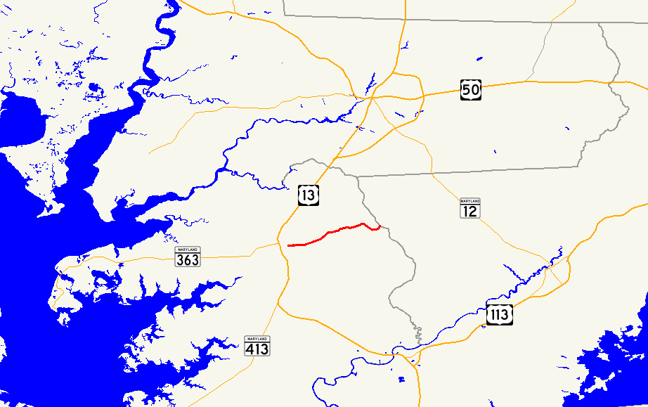
Maryland Route 388 highlighted in redRoute information Maintained by MDSHA Length: 2.38 mi[1] (3.83 km) Major junctions West end:  MD 675 in Princess Anne
East end: End of state maintenance near Princess Anne Location Counties: Somerset Highway system Maryland highway system
Interstate • US • State • Minor • Former • Turnpikes←  MD 387
MD 390  →
→Maryland Route 388 (MD 388) is a state highway in the U.S. state of Maryland. Known for most of its length as West Post Office Road, the state highway runs 2.38 miles (3.83 km) from MD 675 in Princess Anne east to the end of state maintenance east of Princess Anne. MD 388 was constructed in the early 1930s.
Contents
Route description
MD 388 begins as Antioch Avenue at an intersection with MD 675 (Somerset Avenue) in the center of Princess Anne. Antioch Avenue continues west two blocks as a municipal street. MD 388 heads east into farmland after crossing Norfolk Southern Railway's Delmarva Secondary track. The state highway's name changes to West Post Office Road after leaving the town limits of Princess Anne. After passing Freetown Road, MD 388 passes through a stretch of forest, where the highway meets the western end of Perryhawkin Road. After leaving the forest, the state highway reaches its eastern terminus when state maintenance ends at an arbitrary location between two farms. West Post Office Road continues east toward Meadow Bridge Road at the boundary between Somerset County and Worcester County just east of the historic post office in the hamlet of West that gives the road its name.[1][2]
History
Construction of MD 388 as a modern highway began in 1929 and was completed from Princess Anne east to Freetown Road in 1930.[3][4] The remainder of the state highway was paved by 1933.[5][6]
Junction list
The entire route is in Somerset County.
Location Mile
[1]Destinations Notes Princess Anne 0.00 Antioch Avenue west Western terminus MD 675 (Somerset Avenue) – Salisbury, Pocomoke City1.68 Perryhawkin Road east Former MD 696 2.38 West Post Office Road east Eastern terminus 1.000 mi = 1.609 km; 1.000 km = 0.621 mi References
- ^ a b c "Highway Location Reference: Somerset County" (PDF). Maryland State Highway Administration. 2009. http://www.marylandroads.com/Location/2009_SOMERSET.pdf. Retrieved 2010-10-23.
- ^ Google, Inc. Google Maps – Maryland Route 388 (Map). Cartography by Google, Inc. http://maps.google.com/maps?f=d&source=s_d&saddr=Antioch+Ave&daddr=W+Post+Office+Rd&hl=en&geocode=FcToRgIdmgZ9-w%3BFX8JRwIdvKZ9-w&mra=ls&sll=38.20573,-75.671895&sspn=0.03089,0.077162&ie=UTF8&t=h&z=14. Retrieved 2010-05-03.
- ^ Maryland Geological Survey. Map of Maryland Showing State Road System: State Aid Roads and Improved County Road Connections (Map) (1930 ed.).
- ^ Report of the State Roads Commission of Maryland. 1927-1930. Baltimore: Maryland State Roads Commission. 1930-10-01. p. 228. http://www.archive.org/details/reportofstateroa1927mary. Retrieved 2010-05-03.
- ^ Maryland Geological Survey. Map of Maryland Showing State Road System: State Aid Roads and Improved County Road Connections (Map) (1933 ed.).
- ^ Report of the State Roads Commission of Maryland. 1931-1934. Baltimore: Maryland State Roads Commission. 1934-12-28. p. 354. http://www.archive.org/details/reportofstateroa1931mary. Retrieved 2010-05-03.
External links
Roads in Somerset County, Maryland State highways 
U.S. Highways Categories:- State highways in Maryland
- Roads in Somerset County, Maryland


Wikimedia Foundation. 2010.