- Maryland Route 667
-
Maryland Route 667
Old State Road, Crisfield Marion Road, Hudson Corner Road, Rehobeth Road 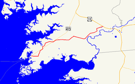
Maryland Route 667 highlighted in redRoute information Maintained by MDSHA Length: 17.61 mi[2] (28.34 km) Existed: 1939[1] – present Major junctions West end: end of state maintenance in Crisfield  MD 413 at Hopewell MD 413 at Marion Station
East end:  US 13 near Pocomoke City
Location Counties: Somerset Highway system Maryland highway system
Interstate • US • State • Minor • Former • Turnpikes←  MD 665
MD 669  →
→Maryland Route 667 (also known as MD 667 or Route 667) is a 17.61-mile (28.34 km) state highway in Somerset County in the U.S. state of Maryland. The east–west route runs from the city of Crisfield, which is located on the Tangier Sound, to U.S. Route 13 west of Pocomoke, and passes through Hopewell, Marion, Hudson's Corner, and Rehobeth along the way. The route serves as a second highway into the lower Somerset County countryside, providing access to these communities from points south (as MD 413 provides access from points north).
Much of MD 667's present-day routing is the former alignment of what is now known as Maryland Route 413, which was assigned as the route was moved to a straighter alignment paralleling the now-defunct Eastern Shore Railroad; the rest, east of Hudson's Corner and known as Rehobeth Road, was formed from absorbing MD 406 after the new alignment of MD 413 was completed. Like its successor, MD 667 is also part of the “Blue Crab Scenic Byway” and the “Beach to Bay Indian Trail”, noted on signs along the route and connecting Ocean City on the Atlantic Ocean to Smith Island in the Chesapeake Bay.
Contents
Route description
Old State Road
Maryland Route 667 begins in Crisfield at its beginning of state maintenance. This is located outside Crisfield's corporate limits, which is just east of the Gandy Lane intersection. The road continues westward from there as Chesapeake Avenue and intersects Somerset Avenue, a major north–south street in the city.[2] It travels through a residential area in almost a perfect eastern trajectory until it hits a sharp, high-banked curve (known locally as “Dead Man's Curve”) which forces many drivers to slow to 20 miles per hour (32 km/h). Now turning northeast, the road passes between Mariners Road and Cash Corner Road. Many foundations of businesses that once stood out on this route are visible in what is now field and marsh.
As it begins to parallel MD 413, Lawson Barnes Road intersects MD 667, and a gentle curve begins as it intersects the Crisfield Highway in the center of Hopewell, near Highway Holiness Church.
Crisfield-Marion Road
MD 667 continues across MD 413, now taking on the name Crisfield–Marion Road. The scenery changes from mostly residential to mostly agricultural, and the speed limit rises to 40 miles per hour (64 km/h). A sharp right curve sends the highway past Saint Peter's Church Road, named for a historic church that has stood for nearly a century. As it continues, turning north, it intersects Hearts Ease Road and, eventually, the western end of Holland Crossing Road which once connected to Hearts Ease Road.
MD 667 enters a tree farm and makes its way east through more homes and open fields as it meets MD 413 once again and enters Marion. It continues across the road and parallels its successor highway, passing the beginning of Whites Road in the process of curving to do so. The speed limit drops to 30 miles per hour (48 km/h) as Crisfield–Marion Road passes through the densely residential community, ending at a four-way stop composed of itself, Charles Cannon Road to the northwest, Tulls Corner Road to the southeast, and Hudson's Corner Road east, continuing MD 667.
Hudson's Corner Road
It follows the latter road out of town, travelling east, and after it passes the Marion post office and Marion Sarah Peyton-Elementary School, the speed limit increases to 50 miles per hour (80 km/h). After a long, wooded stretch, it turns north at Burnettsville Road, which intersects MD 667 with two legs. It continues through another tree farm, which shortly after gives way to a residential area. After intersecting Lovers Lane and crossing a small creek, the road turns right at an intersection in Hudson's Corner, becoming Rehobeth Road. Straight through this intersection is Old Westover–Marion Road, which leads to Westover. The intersection lacks stop signs only on the eastbound side of MD 667; all other points are required to stop, though traffic turning onto Rehobeth Road is warned to slow to 15 miles per hour (24 km/h).
Rehobeth Road
Now taking on the name Rehobeth Road, MD 667 immediately passes over Marumsco Creek[2] and keeps up its 50 miles per hour (80 km/h) speed limit as it passes by the area known as Rehobeth. It intersects Old Rehobeth Road, a former routing of the highway when it was once known as Maryland Route 406.[3] This road grants access to both Rehobeth and Shelltown. Turning northeast, Vessey Orchard Road and Charles Barnes Road intersect the highway; the former road leads to an apple orchard, the latter provides an eventual link to Holly Grove Christian School.
The road winds through an area of mostly open agricultural lands, turning north and slightly west as it intersects Peach Orchard Road, a shortcut to southbound US 13. It continues north and turns east at an intersection with Overholt Road, which also links to the private school. The road bridges Puncheon Landing just before it intersects US 13.
History
At the turn of the 20th century, Crisfield was the second largest city in the state of Maryland and a busy center of activity. The importance of the city of Crisfield led to its main access road, the Crisfield–Westover Road, to become one of the roads slated for improvement by the Maryland State Roads Commission in 1909.[4] Once the Maryland state highway systems was started in 1927, the route was given the designation of MD 413. As it first existed, the Crisfield–Westover Road began at the Crisfield city docks on Main Street, continuing west on present-day Chesapeake Avenue and Old State Road, following the present-day MD 667. It passed through Hopewell near its train station and eventually entered Marion on what was then its Main Street, and continued all the way to Hudson's Corner. Here, the route continued straight onto Old Westover–Marion Road. In Westover, it continued straight onto Sign Post Road, and turned east onto Sam Barnes Road. The road continued eastward from where US 13 is today along an alignment that no longer exists to end at Old Princess Anne Road, a former alignment of US 13.[5]
In Hudson's Corner, the road that incorporates the road eastward to Pocomoke carried MD 406, which at its earliest incarnation followed what is now Old Rehobeth Road until its end at the Pocomoke River in Rehobeth.[6]
As MD 413 was realigned to a new straight highway paralleling the Crisfield Secondary Branch of the Eastern Shore Railroad, MD 667 was brought into existence by the former sections of that route. The first section of what was to become "Crisfield Highway" between Crisfield and Westover was constructed in 1938 and 1939 from the eastern city limits of Crisfield (near the intersection with MD 358) to Hopewell.[1][7]
By the 1960s, Rehobeth Road, still as MD 406, was moved to its current-day alignment and extended to US 13.[8] Additionally, Somerset Avenue was removed from the list of state highways, and all of MD 667 west of it and the city line was removed from the state highway system. Additionally, after US 13 was expanded to a limited-access dual highway, MD 667's eastern terminus was truncated to it. The road east of US 13, presently Davis Store Road, was left in its original macadam construction.
Junction list
The entire route is in Somerset County.
Location Mile[2] Destinations Notes Crisfield 0.00 Begin state maintenance – east of Somerset Avenue Western terminus Hopewell 2.77 MD 413 (Crisfield Highway)Marion Station 5.81 MD 413 (Crisfield Highway)6.55 Charles Cannon Road west / Tulls Corner Road east – Tulls Corner Former MD 357[8][9] (removed 1991)
Becomes Hudson Corner RoadHudson's Corner 10.39 Old Westover–Marion Road – Westover Former MD 413 [3][6] Rehobeth 11.90 Old Rehobeth Road to Shelltown Road – Rehobeth, Shelltown Pocomoke City 15.96 To US 13 (Peach Orchard Road) – Pocomoke City17.61 US 13 (Ocean Highway)Eastern terminus 1.000 mi = 1.609 km; 1.000 km = 0.621 mi References
- ^ a b Maryland State Roads Commission (PDF). Map of Maryland (Map) (1939 ed.). http://commons.wikimedia.org/wiki/File:Maryland_State_Highway_Map_-_1939.pdf. Retrieved 2010-05-05.
- ^ a b c d Maryland State Highway Administration (2009). "Highway Location Reference: Somerset County" (PDF). http://www.marylandroads.com/Location/2009_somerset.pdf. Retrieved 2010-09-03.
- ^ a b Pruett, Mike. "MDRoads: Routes 400-419". MDRoads. http://www.mdroads.com/routes/400-419.html. Retrieved 2009-03-05.
- ^ Report of the State Roads Commission of Maryland. 1927-1930. Baltimore: Maryland State Roads Commission. 1930-10-01. pp. 20–21. http://www.archive.org/details/reportofstateroa1927mary. Retrieved 2010-05-05.
- ^ Maryland State Highway Administration (1927). Map of Maryland (Map). http://www.mdhighwaycentennial.com/images/template/gallery/maps/1927SIDE1.jpg. Retrieved 2009-03-03.
- ^ a b Maryland State Highway Administration (1940). Map of Maryland (Map). http://www.mdhighwaycentennial.com/images/template/gallery/maps/1940SIDE1.jpg. Retrieved 2009-03-03.
- ^ Report of the State Roads Commission of Maryland. 1937-1938. Baltimore: Maryland State Roads Commission. 1939-03-04. p. 97. http://www.archive.org/details/reportofstateroa1937mary. Retrieved 2010-05-05.
- ^ a b Maryland State Highway Administration (1960). Map of Maryland (Map). http://www.mdhighwaycentennial.com/images/template/gallery/maps/1960SIDE1.jpg. Retrieved 2009-03-03.
- ^ Pruett, Mike. "MDRoads: Routes 340-359". MDRoads. http://www.mdroads.com/routes/340-359.html#md357. Retrieved 2009-03-05.
External links
Roads in Somerset County, Maryland State highways 
U.S. Highways Categories:- Crisfield, Maryland
- State highways in Maryland
- Roads in Somerset County, Maryland


Wikimedia Foundation. 2010.