- Maryland Route 347
-
Maryland Route 347
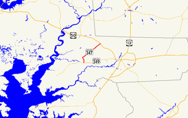
Maryland Route 347 highlighted in redRoute information Maintained by MDSHA Length: 6.92 mi[1] (11.14 km) Major junctions South end:  MD 349 in Quantico
 MD 670 in Hebron
North end:  US 50 in Hebron
Location Counties: Wicomico Highway system Maryland highway system
Interstate • US • State • Minor • Former • Turnpikes←  MD 346
MD 348  →
→Maryland Route 347 (MD 347) is a state highway in the U.S. state of Maryland. The state highway runs 6.92 miles (11.14 km) from MD 349 in Quantico north to U.S. Route 50 (US 50) in Hebron. MD 347 was constructed as a modern highway in Hebron in the mid 1910s. The remainder of the highway was constructed in the late 1920s.
Contents
Route description
MD 347 begins at an intersection with MD 349 (Nanticoke Road) in Quantico. The state highway heads north as two-lane Quantico Road past scattered residences and Westside Primary School. After veering northwest at Catchpenny Road, MD 347 crosses Quantico Creek and passes through the historic center of Quantico. The state highway leaves Quantico after a sharp turn to the northeast at Old Athol Road and passes through farmland. Upon arriving in Hebron, the highway passes Westside Intermediate School and the historic home St. Giles. Within Hebron, MD 347 is known as Main Street and intersects MD 670 (Lillian Street).[1] After leaving Hebron, the state highway continues northeast as Hebron Road, traversing Rewastico Creek before reaching its northern terminus at US 50 (Ocean Gateway).[1][2]
History
The portion of MD 347 between Hebron and what is now US 50 was completed as a state-aid road by 1915.[3] The next segment completed was from MD 349 to the center of Quantico by 1926.[4][5] MD 347 was completed between Hebron and Quantico by 1930.[6]
Junction list
The entire route is in Wicomico County.
Location Mile
[1]Destinations Notes Quantico 0.00 MD 349 (Nanticoke Road) – Salisbury, NanticokeSouthern terminus Hebron 5.88 MD 670 east (Lillian Street)6.92 US 50 (Ocean Gateway) – Cambridge, SalisburyNorthern terminus 1.000 mi = 1.609 km; 1.000 km = 0.621 mi References
- ^ a b c d "Highway Location Reference: Wicomico County" (PDF). Maryland State Highway Administration. 2009. http://www.marylandroads.com/Location/2009_WICOMICO.pdf. Retrieved 2010-10-20.
- ^ Google, Inc. Google Maps – Maryland Route 347 (Map). Cartography by Google, Inc. http://maps.google.com/maps?f=d&source=s_d&saddr=MD-347+N%2FQuantico+Rd&daddr=MD-347+N%2FQuantico+Rd&hl=en&geocode=FWxDSQIdNFR8-w%3BFahlSgId4Ex9-w&mra=ls&sll=38.427605,-75.675888&sspn=0.007716,0.01929&ie=UTF8&t=h&z=12. Retrieved 2010-04-21.
- ^ Report of the State Roads Commission of Maryland. 1912-1915. Baltimore: Maryland State Roads Commission. May 1915. p. 126. http://www.archive.org/details/annualreportsofs1912mary. Retrieved 2010-04-21.
- ^ Report of the State Roads Commission of Maryland. 1924-1926. Baltimore: Maryland State Roads Commission. January 1927. p. 26. http://www.archive.org/details/annualreportsofs1924mary. Retrieved 2010-04-21.
- ^ Maryland Geological Survey. Map of Maryland: Showing State Road System and State Aid Roads (Map) (1927 ed.).
- ^ Maryland Geological Survey. Map of Maryland Showing State Road System: State Aid Roads and Improved County Road Connections (Map) (1930 ed.).
External links
Roads in Wicomico County, Maryland State highways 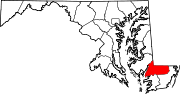
U.S. Highways Categories:- State highways in Maryland
- Roads in Wicomico County, Maryland


Wikimedia Foundation. 2010.