- U.S. Route 11 in Maryland
-
This article is about the section of U.S. Route 11 in Maryland. For the entire length of the highway, see U.S. Route 11.
U.S. Route 11
Route information Maintained by MDSHA, Town of Williamsport, and City of Hagerstown Length: 12.83 mi[2] (20.65 km) Existed: 1926[1] – present Major junctions South end:  US 11 in Williamsport
 MD 68 / MD 63 in Williamsport
 I-81 in Williamsport
 US 40 in Hagerstown
North end: US 11 near MaugansvilleLocation Counties: Washington Highway system United States Numbered Highways
List • Bannered • Divided • ReplacedMaryland highway system
Interstate • US • State • Minor • Former • Turnpikes←  MD 10
MD 10MD 12  →
→U.S. Route 11 (US 11) is a part of the U.S. Highway System that runs from New Orleans, Louisiana to Rouses Point, New York. In Maryland, the federal highway runs 12.83 miles (20.65 km) from the West Virginia state line at the Potomac River in Williamsport north to the Pennsylvania state line near Maugansville. US 11 is the primary north–south surface highway in central Washington County, connecting Hagerstown with Williamsport to the south and Hagerstown Regional Airport to the north. The federal highway was once a major long-distance highway, but that role has been assumed by Interstate 81 (I-81), which parallels US 11 not only in Maryland but for most of its course from Tennessee to Upstate New York. US 11 is maintained by the Maryland State Highway Administration except for the municipally-maintained portions within the corporate limits of Williamsport and Hagerstown.
US 11 is the descendant of a trail blazed through the Great Appalachian Valley in the 18th century. In the 19th century, this trail was upgraded to a pair of turnpikes, one from Williamsport to Hagerstown and the second from Hagerstown to the Pennsylvania state line. The highway was constructed in its modern form in the early 20th century, with the bridge across the Potomac River constructed in 1909 and the old turnpikes paved as all-weather roads by the nascent Maryland State Roads Commission in the 1910s. These highways and the streets of Hagerstown and Williamsport were designated Maryland's portion of US 11 in 1926. The federal highway was improved outside of the towns in the years surrounding 1930 and again around 1950. Since the completion of I-81 in two sections in the late 1950s and mid 1960s removed long-distance traffic from the highway, US 11 has seen its two major relocations: one that removed the highway from downtown Hagerstown and another required by expansion at Hagerstown Regional Airport.
Contents
Route description
 US 11 northbound entering Williamsport
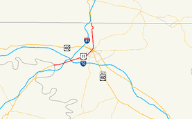
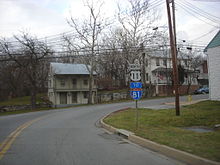
US 11 begins at the West Virginia state line on the south bank of the Potomac River. The highway crosses the Potomac River on a two-lane bridge just south of its confluence with Conococheague Creek. The bridge passes over Potomac Park and the Chesapeake and Ohio Canal National Historical Park. At the east end of the bridge, US 11 enters the town of Williamsport, where the highway is municipally-maintained. The federal highway makes a turn to the north, then makes a sharp turn to the east onto Potomac Street adjacent to the Williamsport Visitor Center of the historical park. Within the Williamsport Historic District, US 11 intersects MD 68 (Conococheague Street) and MD 63. MD 63 joins MD 68 in a concurrency on Conococheague Street to the south and US 11 on Potomac Street east to Artizan Street, where MD 63 heads north out of town. US 11 veers northeast and heads through a more suburban area of Williamsport. The federal highway leaves the town of Williamsport and becomes state-maintained immediately before expanding to a four-lane divided highway for its partial cloverleaf interchange with I-81 (Maryland Veterans Memorial Highway).[2][3]
US 11 continues northeast as Virginia Avenue, a two-lane highway through residential subdivisions. The federal highway passes close to the historic home Tammany and intersects Governor Lane Boulevard, which heads south through an industrial park. US 11 passes under I-70 with no access and enters the suburb of Halfway, where the highway crosses the Winchester and Western Railroad at-grade and at an angle. The federal highway intersects both Massey Boulevard and Halfway Boulevard, which head northwest toward the Valley Mall. US 11 continues into the city of Hagerstown, where the highway becomes municipally-maintained and enters an industrial area. The federal highway crosses Norfolk Southern Railway's Hagerstown District rail line immediately before its intersection with Wilson Boulevard, which heads east. Virginia Avenue, the old alignment of US 11, continues north toward downtown Hagerstown, passing through the South Prospect Street Historic District and passing by Hagerstown City Park, which contains the Hager House and the Washington County Museum of Fine Arts.[2][3]
US 11 turns west onto Burhans Boulevard and immediately crosses over the Norfolk Southern rail line again. The federal highway curves to the north, paralleling the rail line, then crosses over the Winchester and Western rail line as its junction with the Norfork Southern line. US 11 continues north through a residential neighborhood before passing by the Hagerstown Roundhouse Museum and passing under CSX's Lurgan Subdivision just east of its wye with the Norfolk Southern line. At the intersection with Elgin Boulevard and Lanvale Street, US 11 turns east to remain on Burhans Boulevard and starts to parallel the CSX rail line. The federal highway and railroad curve to the north, where the highway intersects US 40 on the opposite side of the tracks from downtown Hagerstown. US 40 consists of a one-way pair, Washington Street eastbound and Franklin Street westbound. Between the two directions of US 40, US 11 passes the historic Western Maryland Railway Station, which is now the headquarters of the Hagerstown Police Department. North of US 40, US 11 intersects Salem Avenue, crosses CSX's Lurgan Branch, and curves north away from CSX's Hanover Subdivision, which turns to the east. Burhans Boulevard reaches its northern end at an oblique three-way intersection with Pennsylvania Avenue.[2][3]
US 11 continues north on Pennsylvania Avenue, passing North Hagerstown High School. State maintenance of the federal highway resumes and the highway's name changes to Middleburg Pike at Haven Road just before the highway leaves the city of Hagerstown. US 11 continues north past residential subdivisions in the suburbs of Fountain Head and Orchard Hills. The federal highway passes a Volvo manufacturing plant and intersects Maugans Avenue, which heads west to Maugansville. North of the intersection with Showalter Road, US 11 adjoins the property of Hagerstown Regional Airport. The federal highway curves to the northeast and passes through a tunnel under the airport's east–west runway. The federal highway curves back to the northwest through an industrial area before resuming its northward course to the Pennsylvania state line. US 11 enters Pennsylvania just south of the federal highway's intersection with PA 163 (Mason Dixon Road).[2][3]
History
US 11 is the descendent of a trail blazed from Pennsylvania following the establishment of Evan Watkins's ferry across the Potomac River at the mouth of Conococheague Creek in 1744. This trail became part of the Great Wagon Road from Philadelphia south through the Great Appalachian Valley to Virginia and North Carolina.[4][5] In the center of the Hagerstown Valley along the trail, German immigrant Jonathan Hager laid out his namesake town in 1762.[4] In the 19th century, the Hagerstown and Middleburg Turnpike was constructed between Hagerstown and Middleburg, a settlement on the Pennsylvania side of the state line.[6][7] In addition. the Williamsport and Hagerstown Turnpike was constructed between the town that sprung up at the Potomac River crossing and the county seat of Washington County.[6] Starting in 1896, the Hagerstown Railway Company of Washington County operated an interurban between Williamsport and Hagerstown adjacent to the turnpike.[8] The streetcar suburb of Halfway developed along the turnpike and trolley line at the midpoint between the two municipalities.[9]
The first portion of modern US 11 to be constructed was the bridge over the Potomac River at Williamsport, which was financed and constructed by Washington County and completed in 1909. The new bridge, which became the only crossing between Cumberland and Washington, D.C. to survive the flood of March 1936, charged tolls from a tollgate at the West Virginia end of the bridge. The Maryland State Roads Commission later purchased the bridge in 1954 and removed the tolls in 1958.[8] Both the Williamsport Pike and Middleburg Pike, their right-of-way now owned by the Maryland State Roads Commission, were paved by 1921.[10] Those highways as well as Potomac Street in the town of Williamsport and the streets connecting the two former turnpikes within the city of Hagerstown—Virginia Avenue, Jonathan Street, and Pennsylvania Avenue—were designated Maryland's portion of US 11 in 1926.[1][11][12]
The first upgrades to US 11 occurred when Williamsport Pike and Middleburg Pike were rebuilt and widened in the late 1920s and early 1930s, respectively.[13][14] Williamsport Pike was rebuilt again in 1948, with the highway widened using the right-of-way of the Williamsport–Hagerstown interurban that had ceased service in 1947.[8][15] By 1950, US 11 in Hagerstown followed a one-way pair: the northbound direction followed Summit Avenue and Jonathan Street between Virginia Avenue and Pennsylvania Avenue and the southbound direction used Prospect Street through the downtown area.[16] The first relief from long-distance traffic came to US 11 when the first section of I-81 was completed from US 40 to the Pennsylvania state line in 1958. Following the completion of I-81 from US 40 south to the Potomac River in 1966, US 11 became a highway mainly for local traffic.[17] US 11's bridge across the Potomac River was rebuilt in 1979.[8] In addition, the highway's name south of Hagerstown was changed from Williamsport Pike to Virginia Avenue around 1995.[18]
Despite the construction of I-81, another bypass of downtown Hagerstown, Burhans Boulevard, was constructed in the 1960s. Burhans Boulevard was named for Winslow F. Burhans, the mayor of Hagerstown from 1953 to 1965 who was instrumental in elevating the tracks of the Western Maryland Railway on the west side of downtown Hagerstown to eliminate a series of grade crossings.[19] The boulevard was started in 1960 between Salem Avenue and Pennsylvania Avenue.[20] Construction was underway on the section between Virginia Avenue and Elgin Boulevard by 1962.[21] Both sections were completed by 1965.[22] Burhans Boulevard was completed around 1968 from Elgin Boulevard to Washington Street, from which the boulevard continued north paralleling the Western Maryland tracks along what had formerly been Foundry Street.[19][23] At the southern end of Hagerstown, Burhans Boulevard, Virginia Avenue, and Wilson Boulevard were relocated to eliminate two grade crossings with the Norfolk Southern Railway tracks in 1983.[24][25] Burhans Boulevard remained a regular municipal street until US 11 was rerouted away from downtown Hagerstown around 1987.[26]
The other major relocation of US 11 occurred around Hagerstown Regional Airport. Due to the airport's east–west runway being extended eastward, US 11 was relocated by Washington County in 1964, resulting in a wide curve in what had been a straight highway.[27] The portion of highway between Showalter Road and the Pennsylvania state line was subsequently county-maintained until 1972.[27][28] Another extension of the east–west runway occurred between 2004 and 2007.[29][30] For this extension, US 11 was relocated to a tunnel underneath the extended runway along the curved alignment in 2006.[29][31][32]
Junction list
The entire route is in Washington County.
Location Mile[2] Destinations Notes Williamsport 0.00 US 11 south – MartinsburgSouthern terminus of US 11 in Maryland; West Virginia state line at Potomac River 0.62 MD 68 (Conococheague Street) / MD 63 south – Boonsboro, Clear Spring, DownsvilleSouth end of concurrency with MD 63 0.75 MD 63 north (Artizan Street) / Artizan Street south – HuyettNorth end of concurrency with MD 63 1.67 I-81 (Maryland Veterans Memorial Highway) – Roanoke, HarrisburgI-81 Exit 2 Halfway 4.42 Halfway Boulevard Hagerstown 5.61 Wilson Boulevard east / Virginia Avenue north US 11 turns west onto Burhans Boulevard; Virginia Avenue is old alignment of US 11 6.84 Elgin Boulevard north / Lanvale Street west US 11 turns east to remain on Burhans Boulevard 7.27 US 40 east (Washington Street)7.37 US 40 west (Franklin Street)7.48 Church Street east / Salem Avenue west to  MD 58
MD 588.31 Pennsylvania Avenue south US 11 continues north on Pennsylvania Avenue; Pennsylvania Avenue south is old alignment of US 11 Fountainhead-Orchard Hills 10.23 Longmeadow Road east / Maugans Avenue west – Maugansville 11.38 Showalter Road west – Hagerstown Regional Airport 12.83 US 11 north – ChambersburgNorthern terminus of US 11 in Maryland; Pennsylvania state line 1.000 mi = 1.609 km; 1.000 km = 0.621 mi References
- ^ a b Bureau of Public Roads (1926) (JPG). United States System of Highways (Map). http://en.wikipedia.org/wiki/File:1926us.jpg. Retrieved 2010-11-19.
- ^ a b c d e f "Highway Location Reference: Washington County" (PDF). Maryland State Highway Administration. 2009. http://www.marylandroads.com/Location/2009_WASHINGTON.pdf. Retrieved 2010-11-17.
- ^ a b c d Google, Inc. Google Maps – U.S. Route 11 in Maryland (Map). Cartography by Google, Inc. http://maps.google.com/maps?f=d&source=s_d&saddr=US-11+N&daddr=S+Burhans+Blvd+E+to:US-11+N%2FPennsylvania+Ave+S&geocode=FfE_XAIdpl9c-w%3BFc3aXAIdw9pd-w%3BFawYXgIdKwZe-w&hl=en&mra=ls&sll=39.72115,-77.724119&sspn=0.000473,0.001206&ie=UTF8&ll=39.659628,-77.704926&spn=0.242633,0.617294&t=h&z=11. Retrieved 2010-11-17.
- ^ a b A History of Road Building in Maryland. Baltimore: Maryland State Roads Commission. 1958. p. 12. http://www.archive.org/details/reportofstateroa1957mary. Retrieved 2010-11-19.
- ^ Meyer, Roger Dean (2006-12-28). "Great Indian Warrior/Trading Path Marker". The Historical Marker Database. Springfield, VA: J.J. Prats. http://www.hmdb.org/marker.asp?marker=797. Retrieved 2010-11-19.
- ^ a b Clark, William Bullock (1899). Report on the Highways of Maryland. Baltimore: Maryland Geological Survey. p. 251. http://books.google.com/books?id=b9l9AAAAIAAJ&printsec=frontcover#v=onepage&q&f=false. Retrieved 2010-11-19.
- ^ United States Geological Survey. Hagerstown, MD quadrangle (Map). 1:48,000. 15 Minute Series (Topographic) (1912 ed.). http://historical.mytopo.com/quad.cfm?quadname=Hagerstown&state=MD&series=15. Retrieved 2010-11-19.
- ^ a b c d Rubin, Mary H. (2005). Williamsport. Charleston, SC: Arcadia Publishing. pp. 119–122, 125. http://books.google.com/books?id=L5l-LWNAlDUC&printsec=frontcover#v=onepage&q&f=false. Retrieved 2010-11-19.
- ^ United States Geological Survey. Williamsport, MD quadrangle (Map). 1:48,000. 15 Minute Series (Topographic) (1912 ed.). http://historical.mytopo.com/quad.cfm?quadname=Williamsport&state=MD&series=15. Retrieved 2010-11-19.
- ^ Maryland Geological Survey. Map of Maryland: Showing State Road System and State Aid Roads (Map) (1921 ed.).
- ^ Maryland Geological Survey. Map of Maryland: Showing State Road System and State Aid Roads (Map) (1927 ed.).
- ^ Maryland State Roads Commission. Map of Maryland Showing State Road System (Map) (1938 ed.).
- ^ Report of the State Roads Commission of Maryland. 1927-1930. Baltimore: Maryland State Roads Commission. 1930-10-01. p. 83. http://www.archive.org/details/reportofstateroa1927mary. Retrieved 2010-11-19.
- ^ Report of the State Roads Commission of Maryland. 1931-1934. Baltimore: Maryland State Roads Commission. 1934-12-28. p. 28. http://www.archive.org/details/reportofstateroa1931mary. Retrieved 2010-11-19.
- ^ Report of the State Roads Commission of Maryland. 1947-1948. Baltimore: Maryland State Roads Commission. 1949-02-15. p. 136. http://www.archive.org/details/reportofstateroa1947mary. Retrieved 2010-11-19.
- ^ Maryland State Roads Commission. Maryland: Official Highway Map (Map) (1950 ed.).
- ^ Ernde, Laura (1999-12-31). "Top 10 events of the 20th century". The Herald-Mail (Hagerstown, MD: The Herald-Mail Company). http://articles.herald-mail.com/1999-12-31/news/25125470_1_flu-epidemic-hagerstown-city-park-century. Retrieved 2011-01-21.
- ^ Maryland State Highway Administration. Maryland: Official Highway Map (Map) (1995 ed.).
- ^ a b Copley, Chris (2010-09-26). "Walking Hagerstown: A stroll through the city's West End". The Herald-Mail (Hagerstown, MD: The Herald-Mail Company). http://articles.herald-mail.com/2010-09-26/news/25194608_1_concrete-bridge-underpass-square-united-methodist-church. Retrieved 2011-01-21.
- ^ "NBI Structure Number: 200000W-H-51010". National Bridge Inventory. http://nationalbridges.com/nbi_record.php?StateCode=42&struct=200000W-H-51010. Retrieved 2010-11-19.
- ^ "NBI Structure Number: 200000W-H-22010". National Bridge Inventory. http://nationalbridges.com/nbi_record.php?StateCode=42&struct=200000W-H-22010. Retrieved 2010-11-19.
- ^ Maryland State Roads Commission. Maryland: Official Highway Map (Map) (1965 ed.).
- ^ Maryland State Roads Commission. Maryland: Official Highway Map (Map) (1968 ed.).
- ^ "NBI Structure Number: 200000W-H-24010". National Bridge Inventory. http://nationalbridges.com/nbi_record.php?StateCode=42&struct=200000W-H-24010. Retrieved 2010-11-19.
- ^ Maryland State Highway Administration. Maryland: Official Highway Map (Map) (1983-84 ed.).
- ^ Maryland State Highway Administration. Maryland: Official Highway Map (Map) (1987 ed.).
- ^ a b Maryland State Roads Commission. Maryland: Official Highway Map (Map) (1964 ed.).
- ^ Maryland State Highway Administration. Maryland: Official Highway Map (Map) (1972 ed.).
- ^ a b Reilly, Tara (2004-07-14). "Runway extension on schedule". The Herald-Mail (Hagerstown, MD: The Herald-Mail Company). http://articles.herald-mail.com/2004-07-14/news/25018621_1_runway-extension-first-phase-extension-project. Retrieved 2011-01-21.
- ^ Bowman, Joshua (2007-11-30). "Hagerstown airport runway extension open". The Herald-Mail (Hagerstown, MD: The Herald-Mail Company). http://articles.herald-mail.com/2007-11-30/news/25032291_1_runway-project-new-runway-runway-extension. Retrieved 2011-01-21.
- ^ Hanna, Karen (2006-11-29). "U.S. 11 opens under airport project". The Herald-Mail (Hagerstown, MD: The Herald-Mail Company). http://articles.herald-mail.com/2006-11-29/news/25063655_1_airport-project-lanes-southbound-traffic. Retrieved 2011-01-21.
- ^ "Highway Location Reference: Washington County" (PDF). Maryland State Highway Administration. 2006. http://www.marylandroads.com/Location/2006_WASHINGTON.pdf. Retrieved 2010-11-19.
External links
U.S. Route 11Previous state:
West VirginiaMaryland Next state:
PennsylvaniaRoads in Washington County, Maryland State highways 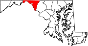
U.S. Highways Interstate Highways Categories:- U.S. Highways in Maryland
- Roads in Washington County, Maryland


Wikimedia Foundation. 2010.