- Interstate 81 in Maryland
-
This article is about the section of Interstate 81 in Maryland. For the entire length of the highway, see Interstate 81.
Interstate 81
Maryland Veterans Memorial Highway 
Route information Maintained by MDSHA Length: 12.08 mi[1] (19.44 km) Major junctions South end:  I-81 in Williamsport
 MD 68 / MD 63 in Williamsport
 US 11 in Williamsport
 I-70 in Halfway
 US 40 in Hagerstown
 MD 58 in Hagerstown
North end:  I-81 near Maugansville
Location Counties: Washington Highway system Main route of the Interstate Highway System
Main • Auxiliary • BusinessMaryland highway system
Interstate • US • State • Minor • Former • Turnpikes←  MD 80
MD 80MD 81  →
→Interstate 81 (I-81) is a part of the Interstate Highway System that runs from Dandridge, Tennessee to Fishers Landing, New York. In Maryland, the Interstate highway runs 12.08 miles (19.44 km) from the West Virginia state line at the Potomac River in Williamsport north to the Pennsylvania state line near Maugansville. I-81 is the primary north–south Interstate highway in Washington County, connecting Hagerstown with Chambersburg and Harrisburg to the north and Martinsburg, Winchester, and Roanoke to the south. I-81, which like all mainline Interstate highways is a part of the National Highway System, is the shortest mainline Interstate in Maryland and contains the shortest portion of I-81 of all six states through which the Interstate highway passes.[2][3] The Interstate was dedicated as Maryland Veterans Memorial Highway in 1987.[3]
The idea of a north–south bypass of Hagerstown to relieve congestion on the contemporary main highway through the Hagerstown Valley, U.S. Route 11 (US 11), predates the Interstate system. Construction on the Hagerstown Bypass began in the mid 1950s and was completed in 1958 from US 40 north to the Pennsylvania state line. I-81 was assigned to the new freeway in 1959. The southern section of the freeway from the Potomac River to US 40 was built starting in 1962 and completed in 1966. Beyond interchange improvements, I-81 has changed very little from the four-lane freeway of the 1960s. Long-range plans call for widening I-81 to six lanes and effecting further interchange improvements along what is a major commuting and trucking corridor.
Contents
Route description
 I-81 northbound at I-70 interchange
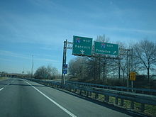
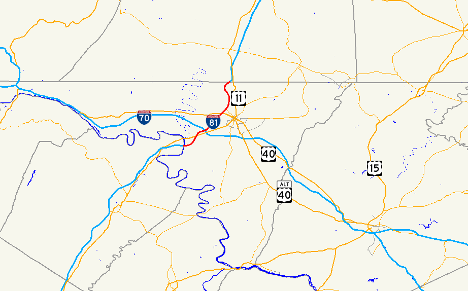
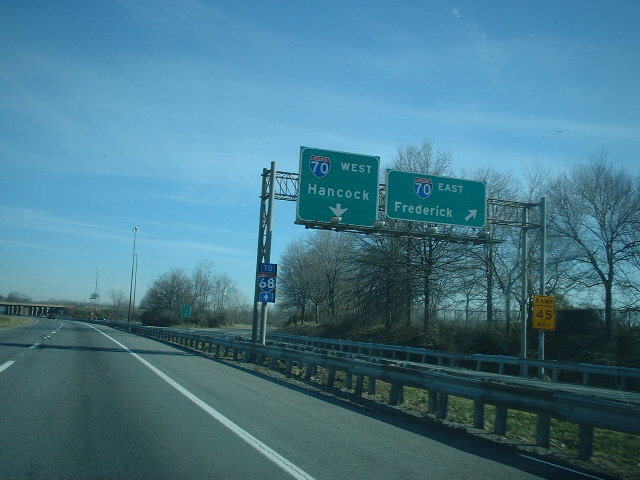
I-81 crosses the Potomac River from West Virginia and enters Maryland as a four-lane freeway with a speed limit of 65 miles per hour (105 km/h). The Interstate curves to the northeast around Williamsport, where the highway meets MD 68 and MD 63 (Lappans Road) at a diamond interchange (Exit 1) to the south of the town and US 11 (Virginia Avenue) at a partial cloverleaf interchange (Exit 2) to the east. Beyond US 11, I-81's speed limit drops to 60 miles per hour (97 km/h). The Interstate passes along the edge of the Hagerstown suburb of Halfway, where the highway meets I-70 (Eisenhower Memorial Highway) at a cloverleaf interchange (Exit 4) with collector-distributor lanes on both I-81 and I-70. Traffic for I-68 is advised to use I-70 west. I-81 meets Halfway Boulevard, which leads to several shopping centers including the Valley Mall, at a partial cloverleaf interchange (Exit 5).[1][4]
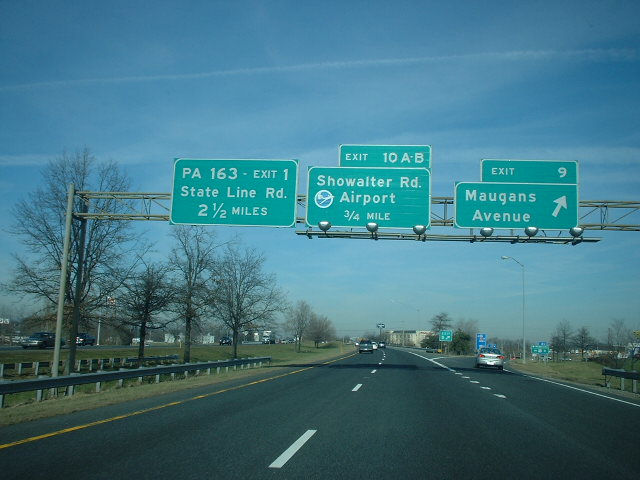
I-81 continues northeast along the west edge of Hagerstown. The Interstate crosses CSX's Lurgan Subdivision and passes under MD 144 with no access before reaching a cloverleaf interchange with US 40 (National Pike) (Exit 6). The freeway intersects MD 58 (Cearfoss Pike) at a partial cloverleaf interchange (Exit 7). Immediately to the north, I-81 has a partial interchange with Maugansville Road (Exit 8) featuring a loop exit ramp from southbound I-81 and a straight entrance ramp to the northbound direction. The Interstate curves to the north and crosses Norfolk Southern Railway's Lurgan Branch. The speed limit increases to 65 miles per hour (105 km/h) as the Interstate passes along the eastern edge of Maugansville, where the highway meets Maugans Avenue at a diamond interchange (Exit 9). I-81 meets Showalter Road, which is used to access Hagerstown Regional Airport, at a cloverleaf interchange (Exit 10) as the freeway gently curves around the airport's runway. The Interstate heads northeast to the Pennsylvania state line, on top of which the highway meets PA 163 (Mason Dixon Road) at Exit 1 of the Pennsylvania exit sequence. The southbound exit ramp to and entrance ramp from PA 163 are in Maryland and the northbound ramps are in Pennsylvania.[1][4]
History
 I-81 northbound at Maugans Avenue interchange
The first section of I-81 to be constructed in Maryland was the pre-Interstate Hagerstown Bypass that was planned to provide relief to the existing north–south highway through downtown Hagerstown, US 11.[5] The highway was planned to run from US 40 west of downtown Hagerstown to the Pennsylvania state line, where the Pennsylvania Department of Highways would continue the bypass north to tie into US 11 near Greencastle.[6] Preliminary engineering on the Hagerstown Bypass began in 1954 and construction began in 1956, by which time a southern extension was planned south to US 11 east of Williamsport.[5][6][7] The freeway was completed from US 40 (now MD 144) to the Pennsylvania state line in 1958, including an interchange with the present alignment of US 40 west of downtown Hagerstown, a highway that was completed around 1963.[8][9] Traffic from the Hagerstown Bypass followed Mason Dixon Road to US 11 until the bypass was extended into Pennsylvania and tied into US 11 around modern Exit 3 in 1960.[10][11][12] The new freeway was marked as I-81 beginning in 1959.[10]
Construction on the portion of I-81 south of US 40 began in 1962 to fill a gap between the portion of I-81 in Maryland and the portion of the Interstate completed between WV 9 near Martinsburg and US 11 southwest of Williamsport in West Virginia.[13] MD 144's bridge over I-81 was constructed in 1963 once the relocated US 40 opened.[9][14] The cloverleaf interchange between I-81 and the future I-70 was constructed in 1964, including the collector/distributor lanes.[15] The remainder of the highway south to the Potomac River, including the bridge over the Potomac River, was under construction by 1965.[16] The southern section of I-81 from the West Virginia state line to US 40 opened in 1966.[3][17]
I-81 remains very similar to when it was completed in 1966. Exit numbers were first marked in 1974; these exit numbers have not changed.[18] The Maugansville Road interchange was originally a full interchange, but was reduced to a partial interchange in 1968.[19][20] The interchange with MD 68 and MD 63 south of Williamsport originally only had a northbound exit ramp and a southbound entrance ramp; ramps to and from the direction of Hagerstown were added between 1981 and 1989.[21][22][23] The junction with Halfway Boulevard was a diamond interchange until it was rebuilt as a partial cloverleaf interchange in 2001.[21][24][25]
Future
I-81 is presently heavily congested within Maryland due to the 1960s era freeway being used as both a commuter route within a rapidly growing metropolitan area as well as a major trucking corridor. In 2009, the highway had a minimum annual average daily traffic of 47,030 between Showalter Road and PA 163 and a maximum of 68,040 between I-70 and Halfway Boulevard.[1] The Interstate is often used by long-distance traffic as an alternative to I-95 to avoid traveling through the major cities of the East Coast. As a result, in 2001 the Maryland State Highway Administration began developing long-term plans to upgrade the entire length of I-81 in Maryland. The state completed the planning process for the eventual upgrades to the Interstate highway in November 2010; the next step is preliminary engineering work. The state plans to expand I-81 to six lanes to address capacity concerns. In addition, many of the interchanges will be rebuilt to reduce or eliminate weaving. In particular:
- The collector-distributor lanes within the I-70 interchange would be extended north through the Halfway Boulevard interchange.
- The US 40 and Showalter Road interchanges would be changed from a full cloverleaf interchange to a partial interchange by removing the two loop ramps from the crossroad onto I-81.
- The MD 58 interchange may be converted from a partial cloverleaf interchange to a diamond interchange.
- The Maugans Avenue diamond interchange may have a loop ramp added from westbound Maugans Avenue to southbound I-81.
At almost every interchange, acceleration and deceleration lanes would be lengthened to modern standards. The ramps within the I-70 interchange would be modified to better handle traffic passing between two freeways. Auxiliary lanes would be added in both directions between the US 40 and MD 58 interchanges, and southbound between the Showalter Road and Maugans Avenue interchanges. In addition, there is an option to construct a truck weigh station somewhere along I-81 within the state; there are presently no weigh stations along either the Maryland or West Virginia segments of I-81.[26]
Exit list
The entire route is in Washington County.
Location Mile[1] Exit Destinations Notes Williamsport 0.00 I-81 south – RoanokeSouthern terminus of I-81 in Maryland; West Virginia state line at Potomac River 0.88 1 MD 68 / MD 63 (Lappans Road) – Williamsport, Boonsboro2.37 2 US 11 (Virginia Avenue) – WilliamsportPartial cloverleaf interchange Halfway 3.63 4  I-70 (Eisenhower Memorial Highway) to I-68 – Frederick, Hancock
Cloverleaf interchange with collector-distributor lanes 4.63 5 Halfway Boulevard Partial cloverleaf interchange; split into exits 5A (east) and 5B (west) Hagerstown 6.85 6 US 40 (National Pike) – Hagerstown, HuyettCloverleaf interchange; split into exits 6A (east) and 6B (west) 7.70 7 MD 58 (Cearfoss Pike) – Hagerstown, CearfossPartial cloverleaf interchange; split into exits 7A (east) and 7B (west) 8.08 8 Maugansville Road Southbound exit and northbound entrance Maugansville 9.59 9 Maugans Avenue 10.42 10 Showalter Road – Hagerstown Regional Airport Cloverleaf interchange; split into exits 10A (east) and 10B (west) 12.08 1  PA 163 (Mason Dixon Road)
Northern terminus of I-81 in Maryland; interchange straddles Pennsylvania state line; southbound ramps are in Maryland and northbound ramps are in Pennsylvania I-81 north – Harrisburg1.000 mi = 1.609 km; 1.000 km = 0.621 mi References
- ^ a b c d e "Highway Location Reference: Washington County" (PDF). Maryland State Highway Administration. 2009. pp. 13–19. http://www.marylandroads.com/Location/2009_WASHINGTON.pdf. Retrieved 2010-11-12.
- ^ Federal Highway Administration (August 2003) (PDF). National Highway System: Maryland (Map). http://www.fhwa.dot.gov/planning/nhs/maps/md/md_Maryland.pdf. Retrieved 2010-11-15.
- ^ a b c "Previous Interstate Facts of the Day". Eisenhower Interstate Highway System Home Page. http://www.fhwa.dot.gov/interstate/previousfacts.cfm. Retrieved 2010-11-15.
- ^ a b Google, Inc. Google Maps – Interstate 81 in Maryland (Map). Cartography by Google, Inc. http://maps.google.com/maps?f=d&source=s_d&saddr=I-81+N&daddr=I-81+N&hl=en&geocode=FX4CXAIdmmZc-w%3BFYkYXgIds-Vd-w&mra=ls&sll=39.721291,-77.732542&sspn=0.003788,0.009645&ie=UTF8&t=h&z=11. Retrieved 2010-11-12.
- ^ a b Report of the State Roads Commission of Maryland. 1957-1958. Baltimore: Maryland State Roads Commission. 1958-12-15. p. 82. http://www.archive.org/details/reportofstateroa1957mary. Retrieved 2010-11-15.
- ^ a b Maryland State Roads Commission. Maryland: Official Highway Map (Map) (1956 ed.).
- ^ Report of the State Roads Commission of Maryland. 1955-1956. Baltimore: Maryland State Roads Commission. 1956-11-02. p. 194. http://www.archive.org/details/reportofstateroa1955mary. Retrieved 2010-11-15.
- ^ Maryland State Roads Commission. Maryland: Official Highway Map (Map) (1958 ed.).
- ^ a b Maryland State Roads Commission. Maryland: Official Highway Map (Map) (1963 ed.).
- ^ a b Maryland State Roads Commission. Maryland: Official Highway Map (Map) (1959 ed.).
- ^ Maryland State Roads Commission. Maryland: Official Highway Map (Map) (1960 ed.).
- ^ "NBI Structure Number: 280163006000000". National Bridge Inventory. http://nationalbridges.com/nbi_record.php?StateCode=42&struct=280163006000000. Retrieved 2010-11-15.
- ^ Maryland State Roads Commission. Maryland: Official Highway Map (Map) (1962 ed.).
- ^ "NBI Structure Number: 100000210069010". National Bridge Inventory. http://nationalbridges.com/nbi_record.php?StateCode=24&struct=100000210069010. Retrieved 2010-11-15.
- ^ "NBI Structure Number: 100000210141010". National Bridge Inventory. http://nationalbridges.com/nbi_record.php?StateCode=24&struct=100000210141010. Retrieved 2010-11-15.
- ^ "NBI Structure Number: 100000210078011". National Bridge Inventory. http://nationalbridges.com/nbi_record.php?StateCode=24&struct=100000210078011. Retrieved 2010-11-15.
- ^ Maryland State Roads Commission. Maryland: Official Highway Map (Map) (1967 ed.).
- ^ Maryland State Highway Administration. Maryland: Official Highway Map (Map) (1974 ed.).
- ^ Maryland State Roads Commission. Maryland: Official Highway Map (Map) (1964 ed.).
- ^ Maryland State Roads Commission. Maryland: Official Highway Map (Map) (1968 ed.).
- ^ a b Maryland State Highway Administration. Maryland: Official Highway Map (Map) (1972 ed.).
- ^ United States Geological Survey (1981-07-01). 10 km SW of Hagerstown, Maryland, United States (Map). Topo Map. http://msrmaps.com/image.aspx?T=2&S=13&Z=18&X=161&Y=2740&W=1&qs=. Retrieved 2010-11-15.
- ^ United States Geological Survey (1989-05-28). 10 km SW of Hagerstown, Maryland, United States (Map). Aerial Map. http://msrmaps.com/image.aspx?T=1&S=12&Z=18&X=322&Y=5481&W=1&qs=. Retrieved 2010-11-15.
- ^ "Highway Location Reference: Washington County" (PDF). Maryland State Highway Administration. 2001. http://www.marylandroads.com/Location/2001_WASHINGTON.pdf. Retrieved 2010-11-15.
- ^ Kulin, Dan; Butki, Scott (2000-12-23). "New year brings new projects for Hagerstown". The Herald-Mail (Hagerstown, MD: The Herald-Mail Company). http://articles.herald-mail.com/2000-12-23/news/25119953_1_transportation-projects-election-winners-million-project. Retrieved 2011-01-21.
- ^ "Project Information: IS 0081 Maryland Veterans Memorial Highway West Virginia State Line To Pennsylvania State Line". Maryland State Highway Administration. http://apps.roads.maryland.gov/WebProjectLifeCycle/ProjectInformation.asp?projectno=WA1281121. Retrieved 2010-11-15.
External links
- I-81 @ MDRoads.com
- I-81 in Maryland @ AARoads: Northbound and Southbound
Interstate 81Previous state:
West VirginiaMaryland Next state:
PennsylvaniaRoads in Washington County, Maryland State highways 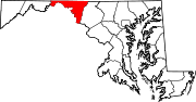
U.S. Highways Interstate Highways Categories:- Interstate Highways in Maryland
- Interstate 81
- Roads in Washington County, Maryland


Wikimedia Foundation. 2010.