- Maryland Route 632
-
Maryland Route 632
Downsville Pike 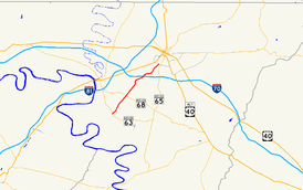
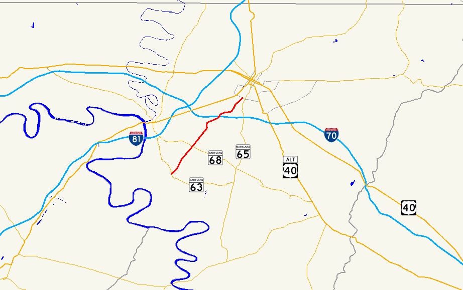
Maryland Route 632 highlighted in redRoute information Maintained by MDSHA Length: 6.71 mi[1] (10.80 km) Major junctions South end:  MD 63 in Downsville
 MD 68 near Downsville
 I-70 in Halfway
North end: Maryland Avenue in Hagerstown Location Counties: Washington Highway system Maryland highway system
Interstate • US • State • Minor • Former • Turnpikes←  MD 631
MD 636  →
→Maryland Route 632 (MD 632) is a state highway in the U.S. state of Maryland. Known as Downsville Pike, the state highway runs 6.71 miles (10.80 km) from MD 63 in Downsville north to Maryland Avenue in Hagerstown. MD 632 was constructed along the path of a former turnpike in the late 1930s. The state highway's interchange with Interstate 70 (I-70) opened in 1999.
Contents
Route description
MD 632 begins at an intersection with MD 63 (Spielman Road) in Downsville. The state highway northeast as a two-lane road through farmland, in the midst of which the highway intersects MD 68 (Lappans Road). MD 632 begins to pass residential subdivisions and industrial properties ahead of its interchange with I-70 (Eisenhower Memorial Highway), through which the state highway is a four-lane divided highway. The intersection with the ramps to and from westbound I-70 is shared with Halfway Boulevard, which heads northwest toward U.S. Route 11 and I-81. MD 632 reduces to two lanes again and passes through the southeastern part of Halfway before crossing over Norfolk Southern Railway's Hagerstown District. The state highway turns north to intersect Oak Ridge Drive, enters the city of Hagerstown, and passes through a forested area before reaching its northern terminus at the intersection of Maryland Avenue and Downsville Pike between South Hagerstown High School to the east and a pair of shopping centers to the west. The roadway continues north as Maryland Avenue toward downtown Hagerstown, while Downsville Pike heads northeast toward Potomac Street just north of MD 65's northern terminus.[1][2]
History
The predecessor highway of MD 632 was the Downsville and Hagerstown Turnpike from Downsville to the Hagerstown and Sharpsburg Turnpike (now MD 65) in Hagerstown.[3] MD 632 was designated and constructed as a modern highway between 1938 and 1940.[4][5] The state highway was reconstructed around 1956.[6] The portion of MD 632 around the I-70 overpass was expanded to a four-lane divided highway in 1968 despite no interchange being constructed at that time.[7] The state highway was relocated in Halfway as part of the grade separation of the highway and the Norfolk Southern Railway line in 1978.[8][9] MD 632's interchange with I-70 was constructed starting in February 1998 and was completed in September 1999.[10][11][12]
Junction list
Location Mile[1] Destinations Notes Downsville 0.00 MD 63 (Spielman Road) – Williamsport, SpielmanSouthern terminus St. James 2.24 MD 68 (Lappans Road) – Williamsport, BoonsboroHalfway 4.92 I-70 (Eisenhower Memorial Highway) – Hancock, FrederickI-70 Exit 28 Hagerstown 6.71 Maryland Avenue north / Downsville Road north Northern terminus 1.000 mi = 1.609 km; 1.000 km = 0.621 mi References
- ^ a b c "Highway Location Reference: Washington County" (PDF). Maryland State Highway Administration. 2009. http://www.marylandroads.com/Location/2009_WASHINGTON.pdf. Retrieved 2010-11-23.
- ^ Google, Inc. Google Maps – Maryland Route 632 (Map). Cartography by Google, Inc. http://maps.google.com/maps?f=d&source=s_d&saddr=MD-632+N%2FDownsville+Pike&daddr=Maryland+Ave&hl=en&geocode=FZB2WwIdVtRc-w%3BFSqaXAIdkORd-w&mra=ls&sll=39.623425,-77.732552&sspn=0.003793,0.009645&ie=UTF8&t=h&z=12. Retrieved 2010-11-23.
- ^ Clark, William Bullock (1899). Report on the Highways of Maryland. Baltimore: Maryland Geological Survey. p. 251. http://books.google.com/books?id=b9l9AAAAIAAJ&printsec=frontcover#v=onepage&q&f=false. Retrieved 2010-11-23.
- ^ Maryland State Roads Commission. Map of Maryland Showing State Road System (Map) (1938 ed.).
- ^ Report of the State Roads Commission of Maryland. 1939-1940. Baltimore: Maryland State Roads Commission. 1941-03-15. p. 120. http://www.archive.org/details/reportofstateroa1939mary. Retrieved 2010-11-23.
- ^ Report of the State Roads Commission of Maryland. 1955-1956. Baltimore: Maryland State Roads Commission. 1956-11-02. p. 193. http://www.archive.org/details/reportofstateroa1955mary. Retrieved 2010-11-23.
- ^ Maryland State Roads Commission. Maryland: Official Highway Map (Map) (1968 ed.).
- ^ Maryland State Highway Administration. Maryland: Official Highway Map (Map) (1978 ed.).
- ^ "NBI Structure Number: 100000210145010". National Bridge Inventory. http://nationalbridges.com/nbi_record.php?StateCode=42&struct=100000210145010. Retrieved 2010-11-23.
- ^ Dennis, Steven T. (1997-05-16). "Work on Downsville Pike interchange to begin in February". The Herald-Mail (Hagerstown, MD: The Herald-Mail Company). http://articles.herald-mail.com/1997-05-16/news/25140174_1_interchange-partial-cloverleaf-cloverleaf-loops. Retrieved 2011-01-22.
- ^ Butki, Scott (1999-09-23). "I-70 interchange set to open Wednesday". The Herald-Mail (Hagerstown, MD: The Herald-Mail Company). http://articles.herald-mail.com/1999-09-23/news/25097930_1_interchange-address-growth-delay. Retrieved 2011-01-22.
- ^ Maryland State Highway Administration. Maryland: Official Highway Map (Map) (1999-2000 ed.).
Roads in Washington County, Maryland State highways 
U.S. Highways Interstate Highways Categories:- State highways in Maryland
- Roads in Washington County, Maryland
- Hagerstown, Maryland


Wikimedia Foundation. 2010.