- Maryland Route 57
-
Maryland Route 57
St. Paul Road 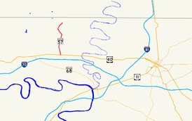
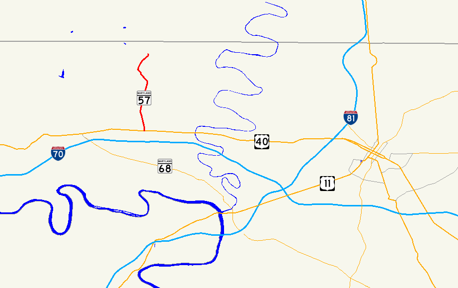
Maryland Route 57 highlighted in redRoute information Maintained by MDSHA Length: 4.02 mi[1] (6.47 km) Major junctions South end:  US 40 near Clear Spring
North end:  MD 494 near Fairview
Location Counties: Washington Highway system Maryland highway system
Interstate • US • State • Minor • Former • Turnpikes←  MD 56
MD 56MD 58  →
→Maryland Route 57 (MD 57) is a state highway in the U.S. state of Maryland. Known as St. Paul Road, the state highway runs 4.02 miles (6.47 km) from U.S. Route 40 (US 40) near Clear Spring north to MD 494 near Fairview. MD 57 was constructed in stages between 1916 and 1933. The state highway originally extended to the Pennsylvania state line, but was rolled back in favor of MD 494 in the early 1960s.
Contents
Route description
MD 57 begins at an intersection with US 40 (National Pike) next to the highway's namesake, St. Paul's Church, east of Clear Spring.[2] After crossing Meadow Brook, the state highway heads north as a two-lane road through farmland, intersecting Broadfording Road and passing over Rockdale Run. Immediately after crossing Dry Run, MD 57 reaches its northern terminus at MD 494 (Fairview Road) west of Fairview. St. Paul Road continues north as a county-maintained road to the Pennsylvania state line.[1][3]
History
MD 57 was constructed as a state-aid road from US 40 to Broadfording Road around 1916.[4] By 1921, the paved portion was extended north to Rockdale Run.[5] The remainder of MD 57 and what is now MD 494 to the Pennsylvania state line were completed by 1933.[6] The segment of MD 494 from MD 57 to the state line was originally part of MD 57.[7] MD 57 was removed from the run to the state line in favor of MD 494 in 1963.[8]
Junction list
The entire route is in Washington County.
Location Mile
[1]Destinations Notes Clear Spring 0.00 US 40 (National Pike) – Hancock, HagerstownSouthern terminus Fairview 4.02 MD 494 (Fairview Road) – Cearfoss, Mercersburg, PANorthern terminus 1.000 mi = 1.609 km; 1.000 km = 0.621 mi References
- ^ a b c "Highway Location Reference: Washington County" (PDF). Maryland State Highway Administration. 2009. http://www.marylandroads.com/Location/2009_WASHINGTON.pdf. Retrieved 2010-11-12.
- ^ "History of Saint Paul's Church". St. Paul's Reformed Church. 2007. http://www.thewhisperingpines.org/index.php?p=1_3_History-of-Saint-Paul-s-Church. Retrieved 2010-03-10.
- ^ Google, Inc. Google Maps – Maryland Route 57 (Map). Cartography by Google, Inc. http://maps.google.com/maps?f=d&source=s_d&saddr=us-40+and+md-57+clear+spring,+md&daddr=md-57+and+md-494+fairview,+md&hl=en&geocode=&mra=ls&sll=39.658967,-77.878947&sspn=0.015165,0.038581&ie=UTF8&t=h&z=13. Retrieved 2010-03-10.
- ^ Report of the State Roads Commission of Maryland. 1916-1919. Baltimore: Maryland State Roads Commission. January 1920. p. 20. http://www.archive.org/details/annualreportsofs1916mary. Retrieved 2010-03-10.
- ^ Maryland Geological Survey. Map of Maryland: Showing State Road System and State Aid Roads (Map) (1921 ed.).
- ^ Maryland Geological Survey. Map of Maryland Showing State Road System: State Aid Roads and Improved County Road Connections (Map) (1933 ed.).
- ^ Maryland State Roads Commission. General Highway Map: State of Maryland (Map) (1939 ed.).
- ^ Maryland State Roads Commission. Maryland: Official Highway Map (Map) (1963 ed.).
External links
Roads in Washington County, Maryland State highways 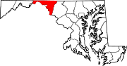
U.S. Highways Interstate Highways Categories:- State highways in Maryland
- Roads in Washington County, Maryland


Wikimedia Foundation. 2010.