- Maryland Route 26
-
Maryland Route 26
Liberty Road, Liberty Heights Avenue 
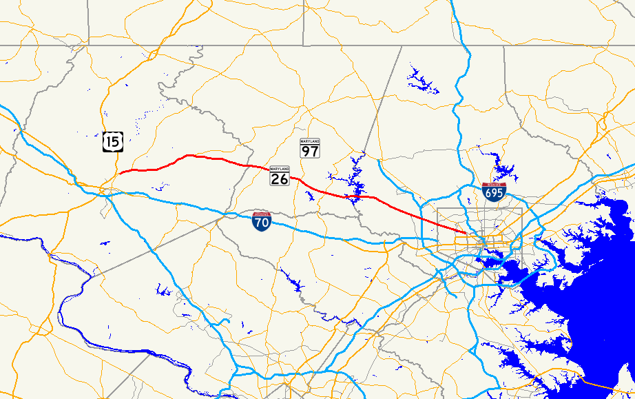
Route information Maintained by MDSHA, Baltimore DOT Length: 44.10 mi[1][2][3][4] (70.97 km) Major junctions West end:  US 15 in Frederick
 MD 194 near Walkersville
 MD 550 in Libertytown
 MD 75 in Libertytown
 MD 31 in Libertytown
 MD 27 in Franklinville
 MD 97 in Dorsey Crossroads
 MD 32 in Eldersburg
 I-695 in Randallstown
East end:  MD 140 in Baltimore
Highway system Maryland highway system
Interstate • US • State • Minor • Former • Turnpikes←  MD 25
MD 25MD 27 →Maryland Route 26 (MD 26) is an east–west state highway in the U.S. state of Maryland. Outside of the Baltimore city limits, it is known as Liberty Road; inside the city limits it is known as Liberty Heights Avenue.
The route is the only east–west thoroughfare in Eldersburg; as a result, it is often congested during peak hours.
Contents
Route description
From the east, MD 26 begins as Liberty Heights Avenue at MD 129, which at that point is known as Swann Drive and runs along the perimeter of Druid Hill Park. A block later, at Mondawmin Mall and Metro Station, the road curves a little to the right, and then continues 3.6 miles (5.8 km) to Kelox Road, where it changes name to Liberty Road. Traffic is heaviest between Washington Avenue and Rolling Road during the day.
From here, in the Lochearn area, the route becomes suburban in character, and continues 6.7 miles (10.8 km) through the Milford Mill and Randallstown areas before narrowing down to two lanes.
After crossing the Liberty Reservoir (about 11 miles (18 km) from the Baltimore City/County line), the road enters Carroll County, widening again into a four-lane road through the Eldersburg area, particularly as it passes the area's commercial development and the major intersection at Maryland Route 32.
The road continues west until its end at an interchange with US 15 in Frederick. The route is a major thoroughfare in Carroll and Frederick and counties, serving many small towns between Baltimore and Frederick.
Major bridges
Route 26 has a long crossing of the Liberty Reservoir between Baltimore and Carroll Counties. The bridge is divided into two sections.
There is also a crossing of the Monocacy River, which in a westbound direction, has an arch-bridge structure.
Public transportation
In Baltimore City and County, there are two main bus lines operated by the Maryland Transit Administration along MD 26.
- Route 52 operates from the beginning of Liberty Heights Avenue at the Mondawmin Metro Subway Station in Baltimore City to the intersection of Liberty and Rolling Roads, then loops via Rolling, Church Lane, and Milford Mill Road. Service operates every 8–22 minutes, depending on the time of day.
- Route 54 provides service from Milford Mill Road to a loop near Chapman Road (across from Liberty Ford) in Randallstown, and connects to the Metro Subway along Milford Mill Road. Service is provided every 20–30 minutes at most times, depending on the time of day.
- Route 77 also overlaps with Route 54 line between Milford Mill and Old Court Roads. In addition, several other bus lines operate on various streets intersecting with Liberty Road inside of Baltimore City line. These include routes 51 on Hilton Street, 91 on Garrison Boulevard, 57 on Gwynn Oak Avenue, and 44 on Rogers Avenue.
- TransIT (Frederick County's transit service) provides service on Route 85 to the Wal-Mart at the end of MD-26 in Frederick.
There is no public transportation anywhere on Liberty Road west of the Chapman Road loop. Efforts to initiate such service in the past have failed, mostly due to community opposition.
History
Maryland Route 26 served as a primary route connecting Baltimore to Frederick prior to the arrival of US 40 and I-70. At one time, MD 31 ran to Frederick and MD 26 began when MD 31 turned north to New Windsor and Westminster.
Junction list
County Location Mile
[1][2][3][4]Road Notes Frederick Frederick 0.00 US 15 (Catoctin Mountain Highway)Western terminus, interchange 0.54 Wormans Mill Road Former MD 355 2.20 MD 194 north (Woodsboro Pike)Southern terminus of MD 194 Libertytown 9.35 MD 550 north (Woodsboro Road)Southern terminus of MD 550 9.69 MD 75 (Green Valley Road)10.11 MD 31 east (New Windsor Road)Carroll Taylorsville 18.32 MD 27 (Ridge Road)Freedom 23.04 MD 97 (Old Washington Road)Interchange Eldersburg 26.62 MD 32 (Sykesville Road)Baltimore Randallstown 36.67 Old Court Road Milford 38.64 I-695 (Baltimore Beltway) – Towson, Glen BurnieInterchange Baltimore City 44.10 MD 140 (Reisterstown Road)Eastern terminus Related routes
References
- ^ a b "Highway Location Reference: Frederick County" (PDF). Maryland State Highway Administration. 2008. http://apps.roads.maryland.gov/KeepingCurrent/performTrafficStudies/dataAndStats/hwyLocationRef/2008_hlr_all/co10.pdf. Retrieved 2010-02-26.
- ^ a b "Highway Location Reference: Carroll County" (PDF). Maryland State Highway Administration. 2008. http://apps.roads.maryland.gov/KeepingCurrent/performTrafficStudies/dataAndStats/hwyLocationRef/2008_hlr_all/co06.pdf. Retrieved 2010-02-26.
- ^ a b "Highway Location Reference: Baltimore County" (PDF). Maryland State Highway Administration. 2008. http://apps.roads.maryland.gov/KeepingCurrent/performTrafficStudies/dataAndStats/hwyLocationRef/2008_hlr_all/co03.pdf. Retrieved 2010-02-27.
- ^ a b "Highway Location Reference: Baltimore City" (PDF). Maryland State Highway Administration. 2005. http://apps.roads.maryland.gov/KeepingCurrent/performTrafficStudies/dataAndStats/hwyLocationRef/2005_hlr_all/co24.pdf. Retrieved 2009-04-15.
External links
- MD 26 @ MDRoads.com
- Key points on MD-26 on Google Street View
Annapolis Road · Aliceanna Street · Artmuseum Drive · Baltimore Street · Bellona Avenue · Biddle Street · Boston Street · Broadway · Broening Highway · Calvert Street · Cathedral Street · Caton Avenue · Centre Street · Charles Street · Chase Street · Coldspring Lane-Moravia Road · Druid Hill Avenue · Eager Street · Eastern Avenue · Eutaw Street · Falls Road · Fayette Street · Fleet Street · Franklin Street · Gay Street · Greene Street · Greenmount Avenue · Greene Street · Greenspring Avenue · Guilford Avenue · Gwynns Falls Parkway · Greenmount Avenue · Hanover Street · Harford Road · Hilton Street/Hilton Parkway · Howard Street · Key Highway · Liberty Heights Avenue · Loch Raven Boulevard · Lexington Street · Lombard Street · Madison Street · Maryland Avenue · McCulloh Street · Monument Street · Mt. Royal Avenue · Mulberry Street · North Avenue · Northern Parkway · Paca Street · Park Heights Avenue · Paca Street · Park Avenue · Patapsco Avenue · Pennsylvania Avenue · Pratt Street · Preston Street · Reisterstown Road · Roland Avenue · Russell Street · St. Paul Street · Saratoga Street · The Alameda · University Parkway · Wabash Avenue · York Road
Categories:- State highways in Maryland
- Roads in Baltimore County, Maryland
- Roads in Baltimore, Maryland

Wikimedia Foundation. 2010.