- Maryland Route 259
-
Maryland Route 259
Greenock Road 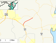
Route information Maintained by MDSHA Length: 2.67 mi[1] (4.30 km) Major junctions South end:  MD 794 in Bristol
North end:  MD 408 near Lothian
Highway system Maryland highway system
Interstate • US • State • Minor • Former • Turnpikes←  MD 258
MD 260  →
→Maryland Route 259 (MD 259) is a state highway in the U.S. state of Maryland. Known as Greenock Road, the route runs 2.67 mi (4.30 km) from Maryland Route 794 in Bristol north to Maryland Route 408 near Lothian.
Contents
Route description
Maryland Route 259 begins at an acute intersection with Maryland Route 794 (Southern Maryland Boulevard). Heading south on MD 794 leads to Maryland Route 258, as well as on-ramps to the Maryland Route 4 expressway, which is also known as Southern Maryland Boulevard. The road heads northeast as a two-lane road with a speed limit of 45 mph (72 km/h) through an area of farms. One of those farms is the historic James Owens Farm, which is located 0.8 mi (1.3 km) north of the southern terminus. After an intersection with Brookswood Road, MD 258 turns north and meets its end at Maryland Route 408 (Mount Zion Road) in the hamlet of Greenock near Lothian.
History
The northern half of Maryland Route 259 was paved by 1933.[2] The whole length was complete by 1935.[3] The 1939 Maryland state highway map shows MD 259 assigned to the length of this road.[4]
Junction list
The entire route is in Anne Arundel County.
Location Mile[1] Destinations Notes Bristol 0.00 MD 794 (Southern Maryland Boulevard)Western terminus (To MD 4, MD 258)
Lothian 2.59 Brookswood Road 2.67 MD 408 (Mount Zion Road) – Lothian, Upper MarlboroEastern terminus References
- ^ a b Maryland State Highway Administration (2008). "Highway Location Reference: Anne Arundel County" (PDF). http://apps.roads.maryland.gov/KeepingCurrent/performTrafficStudies/dataAndStats/hwyLocationRef/2008_hlr_all/co02.pdf. Retrieved 2010-01-09.
- ^ Maryland State Highway Administration (1933). "Map of Maryland" (PDF). http://commons.wikimedia.org/wiki/File:Maryland_State_Highway_Map_-_1933.pdf. Retrieved 2010-01-10.
- ^ Maryland State Highway Administration (1935). "Map of Maryland" (PDF). http://commons.wikimedia.org/wiki/File:Maryland_State_Highway_Map_-_1935.pdf. Retrieved 2010-01-10.
- ^ Maryland State Highway Administration (1939). "Map of Maryland" (PDF). http://commons.wikimedia.org/wiki/File:Maryland_State_Highway_Map_-_1939.pdf. Retrieved 2010-01-10.
External links
Categories:- State highways in Maryland
- Roads in Anne Arundel County, Maryland


Wikimedia Foundation. 2010.