- Maryland Route 255
-
Maryland Route 255
Owensville Road, Galesville Road, Main Street 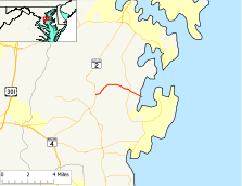
Route information Maintained by MDSHA Length: 4.21 mi[1] (6.78 km) Major junctions West end:  MD 2 in Owensville
 MD 468 in Galesville
East end: Riverside Drive in Galesville Highway system Maryland highway system
Interstate • US • State • Minor • Former • Turnpikes←  MD 254
MD 256  →
→Maryland Route 255 (MD 255) is a state highway in the U.S. state of Maryland. The route runs 4.21 mi (6.78 km) from Maryland Route 2 in Owensville east to Riverside Drive in Galesville.
Contents
Route description
Maryland Route 255 begins at an intersection with Maryland Route 2 (Solomons Island Road) in Owensville. The route heads east as a two-lane road with a speed limit of 40 mph (64 km/h) through a forested area. MD 255 then enters the Owensville Historic District. Within the historic district, the road intersects Owensville Sudley Road, where the speed limit drops to 30 mph (48 km/h). After passing historic Christ Church, the speed limit goes up to 45 mph (72 km/h). MD 255 leaves Owensville and continues east through an area of forests, farmland, and scattered residences on large lots until the road reaches Maryland Route 468 (Muddy Creek Road).
After MD 468, the name of the road changes to Galesville Road, the speed limit drops to 30 mph (48 km/h), and the route heads straight into the unincorporated village of Galesville. After passing Woodfield Road, the road changes its name to Main Street and passes the Galesville Heritage House. The road then comes to an end at Riverside Drive, which parallels the West River and leads to the West River Sailing Club.
History
Maryland Route 255 was paved from MD 2 to MD 468 by 1927.[2] However, instead of heading into Galesville, MD 255 originally turned south and used the present route of MD 468 to Shady Side. This road was paved from Galesville to east of Churchton. The road to Shady Side and the road into Galesville were paved by 1933.[3] The 1939 Maryland state highway map shows MD 255 assigned to that circuitous route, while MD 393 was assigned to the road into Galesville.[4] MD 255 and MD 468 assumed their current alignments in 1949.[5]
Junction list
The entire route is in Anne Arundel County.
Location Mile[1] Destinations Notes Owensville 0.00 MD 2 (Solomons Island Road) – Annapolis, Prince FrederickWestern terminus 0.74 Owensville Sudley Road Galesville 3.15 MD 468 (Muddy Creek Road) – Mayo, Shady Side3.88 Woodfield Road 4.21 Riverside Drive Eastern terminus References
- ^ a b Maryland State Highway Administration (2008). "Highway Location Reference: Anne Arundel County" (PDF). http://apps.roads.maryland.gov/KeepingCurrent/performTrafficStudies/dataAndStats/hwyLocationRef/2008_hlr_all/co02.pdf. Retrieved 2010-01-08.
- ^ Maryland State Highway Administration (1927). "Map of Maryland" (JPG). http://www.mdhighwaycentennial.com/images/template/gallery/maps/1927SIDE1.jpg. Retrieved 2010-01-08.
- ^ Maryland State Highway Administration (1933). "Map of Maryland" (PDF). http://commons.wikimedia.org/wiki/File:Maryland_State_Highway_Map_-_1933.pdf. Retrieved 2010-01-08.
- ^ Maryland State Highway Administration (1939). "Map of Maryland" (PDF). http://commons.wikimedia.org/wiki/File:Maryland_State_Highway_Map_-_1939.pdf. Retrieved 2010-01-08.
- ^ Maryland State Highway Administration (1949). "Map of Maryland" (PDF). http://commons.wikimedia.org/wiki/File:Maryland_State_Highway_Map_-_1949.pdf. Retrieved 2010-01-08.
External links
Categories:- State highways in Maryland
- Roads in Anne Arundel County, Maryland


Wikimedia Foundation. 2010.