- Maryland Route 173
-
Maryland Route 173
Fort Smallwood Road 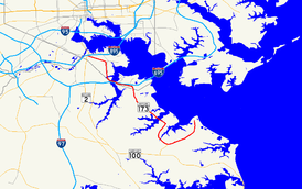
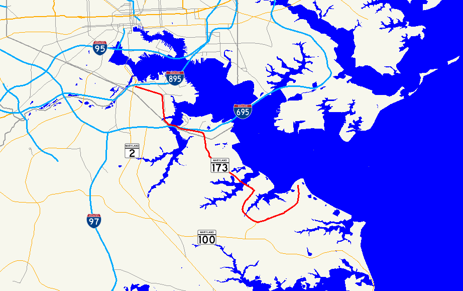
Maryland Route 173 highlighted in redRoute information Maintained by MDSHA and Baltimore DOT Length: 13.78 mi[1][2] (22.18 km) Major junctions South end: Entrance to Fort Smallwood Park in Fairview  MD 607 in Jacobsville
 I-695 in Baltimore
 MD 710 in Baltimore
 MD 171 in Baltimore
North end:  MD 2 in Baltimore
Highway system Maryland highway system
Interstate • US • State • Minor • Former • Turnpikes←  MD 172
MD 174  →
→Maryland Route 173 (MD 173) is a state highway in the U.S. state of Maryland. Known for most of its length as Fort Smallwood Road, the state highway runs 13.78 mi (22.18 km) from Fort Smallwood Park near Fairview north to MD 2 in the Brooklyn neighborhood of Baltimore. MD 173 connects the beach communities of Riviera Beach and Orchard Beach in northeastern Anne Arundel County with industrial areas in the Baltimore neighborhoods of Hawkins Point and Curtis Bay, including the United States Coast Guard Yard. As the primary connection between Interstate 695 (I-695) and industrial facilities in Curtis Bay, the state highway is part of the National Highway System as an intermodal connector between Quarantine Road in Hawkins Point and Patapsco Avenue in Curtis Bay.[3] MD 173 was originally constructed in the 1920s and 1930s. The state highway was put in its modern form with the completion of the bridge over Stony Creek in the late 1940s and expansion to a divided highway along part of its length in the 1970s.
Contents
Route description
MD 173 begins at the entrance to Fort Smallwood Park near the unincorporated community of Fairview.[4] The state highway heads south as Fort Smallwood Road, a two-lane road with a speed limit of 45 mph (72 km/h) that passes by several small beach communities on the Hog Neck peninsula. After intersecting Bayside Beach Road, MD 173 turns southwest and passes along the northern edge of Jacobsville, where the speed limit drops to 40 mph (64 km/h) and the state highway meets the northern end of MD 607 (Hog Neck Road). The state highway crosses Rock Creek and passes a section of old alignment designated MD 173A before the intersection with Edwin Raynor Boulevard, where the state highway turns north onto a four-lane divided highway.[1][4] MD 173 passes Northeast Senior High School before the highway reduces to a three-lane road with center turn lane at the intersection with Duvall Highway.[4]
MD 173 continues north into Riviera Beach. At the intersection with Riviera Drive and Bar Harbor Road, the state highway turns west. The speed limit decreases to 35 mph (56 km/h) and the highway crosses Stony Creek on a drawbridge.[1][4] In Orchard Beach, MD 173 passes MD 642 (Greenland Beach Road), then expands to a five-lane road with center turn lane.[1] At Cox Creek, the state highway becomes a four-lane divided highway with a speed limit of 50 mph (80 km/h) and passes the Herbert A. Wagner Generating Station. MD 173 turns north at Solley Road and passes Marley Neck Boulevard before entering the city of Baltimore.[1][4] Upon entering Hawkins Point, the state highway meets Fort Armistead Road, which leads to Fort Armistead Park and an entrance ramp to eastbound I-695 (Baltimore Beltway).[4] MD 173 turns west and its name changes to Hawkins Point Road before the highway intersects Quarantine Road, which leads to Interchange 1 of I-695.[2][4]
MD 173 continues west as a four-lane undivided highway through the industrial area of Hawkins Point. The state highway passes MD 172 (Arundel Cove Road) and then the access road to the U.S. Coast Guard Yard.[2][4] MD 173 crosses a CSX railroad line and expands to a divided highway.[4] The state highway, now named Pennington Avenue, crosses under I-695 and then over Curtis Creek on a drawbridge.[2][4] The state highway meets MD 710 (Ordnance Road) before reducing to an undivided highway and crossing Cabin Branch.[4] MD 173 continues north across a CSX rail line at-grade and enters the neighborhood of Curtis Bay. At Birch Street, the northbound direction of MD 173 turns east and then north onto Curtis Avenue, while the southbound direction uses Pennington Avenue through the neighborhood.[2][4] Curtis Avenue divides the residential and industrial portions of the neighborhood. MD 173 meets MD 171 (Church Street) within Curtis Bay. At the northern end of the neighborhood, the one-way pair ends and MD 173 turns west onto Patapsco Avenue toward Brooklyn.[4] The state highway crosses MD 686 (2nd Street) before the westbound direction has an entrance ramp to I-895 (Harbor Tunnel Thruway).[2] MD 173 then meets its western terminus at MD 2 (Potee Street). Patapsco Avenue continues as a municipal highway across the Patapsco River toward Southwest Baltimore.[4]
History
MD 173 was paved from MD 2 to the southern end of the Curtis Bay neighborhood, as well as from MD 172 to Marley Neck Road in Orchard Beach, in 1927.[5] By 1930, pavement was extended east to Stony Creek.[6] The highway was completed in Anne Arundel County in 1933 and within Baltimore by 1935.[7][8][9] The present bridge over Stony Creek was constructed in 1947, replacing a one-lane bridge.[7][10] MD 173 was widened from Orchard Beach to MD 710 in the late 1970s and north to the Curtis Bay neighborhood in the mid 1980s.[7][11]
Junction list
County Location Mile
[1][2]Destinations Notes Anne Arundel 8.92 miles (14.36 km)
Fairview 0.00 Entrance to Fort Smallwood Park Southern terminus Jacobsville 3.00 MD 607 south (Hog Neck Road) – Jacobsville3.91 Edwin Raynor Boulevard south – Pasadena MD 173 turns north at this intersection Riviera Beach 5.18 Bar Harbor Road east / Riviera Drive north MD 173 turns west at this intersection Baltimore City 4.86 miles (7.82 km)
8.99 Fort Armistead Road east to I-695 east (Baltimore Beltway) – Essex9.36 Quarantine Road north to I-695 (Baltimore Beltway) – Glen Burnie, Essex10.76 MD 710 west (Ordnance Road) – Glen Burnie11.82 MD 171 west (Church Street) – Brooklyn Park12.49 Patapsco Avenue east – Port of Baltimore MD 173 turns west onto Patapsco Avenue 13.74  I-895 north (Harbor Tunnel Thruway) – New York
Exit from westbound MD 173 13.78 MD 2 (Potee Street) – Glen Burnie, Downtown BaltimoreNorthern terminus Patapsco Avenue west Auxiliary route
MD 173A is the unsigned designation for a bypassed section of MD 173 near the intersection of that highway and Edwin Raynor Boulevard.[12] MD 173A runs 0.14 mi (0.23 km) from MD 173 north to Rock Hill Road near Jacobsville.[1] The state highway was assigned in 2001 when the intersection of MD 173 and Edwin Raynor Boulevard was rebuilt so the roads meet at a right angle.[13]
References
- ^ a b c d e f g "2009 Highway Location Reference: Anne Arundel County" (PDF). Maryland State Highway Administration. 2009. http://www.marylandroads.com/Location/2009_ARUNDEL.pdf. Retrieved 2011-04-16.
- ^ a b c d e f g "2005 Highway Location Reference: Baltimore City" (PDF). Maryland State Highway Administration. 2005. http://www.marylandroads.com/Location/2005_BALTIMORECITY.pdf. Retrieved 2011-04-16.
- ^ Federal Highway Administration (August 2003) (PDF). National Highway System: Baltimore, MD (Map). http://www.fhwa.dot.gov/planning/nhs//maps/md/baltimore_md.pdf. Retrieved 2010-03-21.
- ^ a b c d e f g h i j k l m n Google, Inc. Google Maps – Maryland Route 173 (Map). Cartography by Google, Inc. http://maps.google.com/maps?f=d&source=s_d&saddr=Fort+Smallwood+Rd&daddr=39.172165,-76.53616+to:E+Patapsco+Ave&hl=en&geocode=FUyOVQIdevtw-w%3BFUW4VQIdoCZw-ym5D9Plbf63iTF7NYsVMxs72Q%3BFUi9VgIdnANv-w&mra=ls&sll=39.142044,-76.529903&sspn=0.06111,0.154324&ie=UTF8&t=h&z=12&via=1. Retrieved 2010-03-21.
- ^ Maryland State Roads Commission (JPG). Map of Maryland (Map) (1927 ed.). http://www.mdhighwaycentennial.com/images/template/gallery/maps/1927SIDE1.jpg. Retrieved 2010-03-21.
- ^ Maryland State Roads Commission (JPG). Map of Maryland (Map) (1930 ed.). http://commons.wikimedia.org/wiki/File:Maryland_State_Highway_Map_-_1930.jpg. Retrieved 2010-03-21.
- ^ a b c Svirsky, Alexander. "National Bridge Inventory Database". http://nationalbridges.com/. Retrieved 2010-03-21.
- ^ Maryland State Roads Commission (PDF). Map of Maryland (Map) (1933 ed.). http://commons.wikimedia.org/wiki/File:Maryland_State_Highway_Map_-_1933.pdf. Retrieved 2010-03-21.
- ^ Maryland State Roads Commission (PDF). Map of Maryland (Map) (1935 ed.). http://commons.wikimedia.org/wiki/File:Maryland_State_Highway_Map_-_1935.pdf. Retrieved 2010-03-21.
- ^ Riviera Community Improvement Association. "Beach History - Riviera Beach MD". http://riviera-beach-md.org/RBHistory.htm. Retrieved 2010-03-21.
- ^ Maryland State Highway Administration (PDF). Map of Maryland (Map) (1980 ed.). http://commons.wikimedia.org/wiki/File:Maryland_State_Highway_Map_-_1980.pdf. Retrieved 2010-03-21.
- ^ Google, Inc. Google Maps – Maryland Route 173A (Map). Cartography by Google, Inc. http://maps.google.com/maps?f=d&source=s_d&saddr=Unknown+road&daddr=Rockhill+Rd&hl=en&geocode=FYo8VQIdRFBw-w%3BFVxDVQIdhFBw-w&mra=ls&sll=39.140904,-76.525065&sspn=0.003819,0.009645&ie=UTF8&t=h&z=18. Retrieved 2010-03-21.
- ^ "Highway Location Reference: Anne Arundel County" (PDF). Maryland State Highway Administration. 2001. http://apps.roads.maryland.gov/KeepingCurrent/performTrafficStudies/dataAndStats/hwyLocationRef/2001_hlr_all/co02.pdf. Retrieved 2010-03-21.
External links
Categories:- State highways in Maryland
- Roads in Anne Arundel County, Maryland
- Roads in Baltimore, Maryland

Wikimedia Foundation. 2010.