- Maryland Route 179
-
Maryland Route 179 Saint Margaret's Road 
Route information Maintained by MDSHA Length: 3.16 mi[1] (5.09 km) Major junctions West end:  MD 648 near Annapolis
 MD 908

 US 50 / US 301 in Cape Saint Claire
East end: End of state maintenance in Cape Saint Claire Highway system Maryland highway system
Interstate • US • State • Minor • Former • Turnpikes←  MD 178
MD 180  →
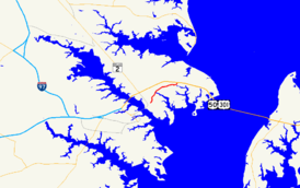
→Maryland Route 179 (MD 179) is a two-lane road running east–west along the Broadneck Peninsula of Anne Arundel County, Maryland. It is better known locally as St. Margaret's Road. MD 179 runs from outside of Annapolis to the end of state maintenance in Cape St. Claire.
Route description
Maryland Route 179 begins at an intersection with MD 648 (Baltimore–Annapolis Boulevard). It proceeds northeast from there, passing through a small suburban neighborhood on Saint Margaret's Road, a two-lane road, eventually entering a small forest. As it continues north, it bridges Mill Creek and turns east, forming the main route of a small community south of Cape St. Claire as it travels toward the US 50 freeway. After bridging US 50 and interchanging with it, dualizing briefly to do so, its name changes to Cape Saint Claire Road and it continues straight toward its namesake community, entering a small retail area. After passing Woodland Circle, which leads to a small cluster of homes, MD 179 comes to an end just beyond this intersection. The road, however, continues north into the town.
Junction list
The entire route is in Anne Arundel County.
Location Mile
[1]Intersection Notes Annapolis 0.00  MD 648 (Baltimore Annapolis Boulevard)
Western terminus Cape St. Claire 2.42  MD 908 (Buschs Frontage Road/Whitehall Road)
2.58 
 US 50 / US 301 (Blue Star Memorial Highway) – Bay Bridge, Washington
US 50/301 exit 29 3.16 End of state maintenance Eastern terminus References
Categories:- State highways in Maryland
- Roads in Anne Arundel County, Maryland
Wikimedia Foundation. 2010.

