- Old Court Road
-
Old Court Road

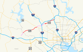
Old Court Road in pink, with Maryland Highway segments of it in redRoute information Maintained by MDSHA Length: 13 mi[1][2] (21 km) Major junctions West end:  MD 99 in Woodstock
East end:  MD 25 near Ruxton
Highway system Maryland highway system
Interstate • US • State • Minor • Former • Turnpikes←  MD 124
MD 128  →
→←  MD 132
MD 134  →
→Old Court Road is a major cross-county road in the central region of the U.S. state of Maryland, running east–west for approximately 13 miles (21 km) through Baltimore County, Maryland from just inside Howard County, Maryland at Woodstock on the Patapsco River to Maryland Route 25 (Falls Road) near Towson. The road exists as both Maryland Route 125 (MD 125) and Maryland Route 133 (MD 133), with several sections not maintained by the state.
Contents
Route description
Beginnings in Howard County
The road that becomes Old Court Road begins at Maryland Route 99 (Old Frederick Road) in Woodstock, Howard County, where it is named Woodstock Road and maintained by Howard County. From MD 99, it runs generally northeast as a two-lane road in open countryside.
MD 125 designation and continuation into Baltimore County
While still in Howard County, just prior to a grade crossing of the CSX Transportation Old Main Line at Woodstock, the road becomes Maryland Route 125, and crosses the Patapsco River into Baltimore County.[1]
Once inside Baltimore County, the road is named Old Court Road. After passing through Patapsco Valley State Park, it winds past Granite and continues through open country.
State maintenance, and the MD 125 designation, ends about half a mile east of Brice Run (a small creek east of the Dogwood Road intersection) at a seemingly arbitrary location (save for the fact that it is precisely 3.5 miles (5.6 km) from the county line[2]), being at neither an intersection, bridge, nor any other significant feature. This makes MD 125, at 3.59 miles (5.78 km) in length,[1][2] rather unique in that it does not intersect any other signed Maryland state highways. According to a local story, the reason for this is a Baltimore County politician who promised Jesuits at Woodstock College that, if they successfully voted him into office, he would have the state purchase and improve this portion of the road, which the Jesuits used for farming-related transportation.
Non-state section
Old Court Road continues to the northeast and begins to pick up development after passing the Ridge Road intersection, surrounded by a few housing developments and stores. The road widens to four lanes and dualizes for a short stretch around its MD 26 (Liberty Road) intersection. The route then shrinks down after carrying a shared left-turn lane, still carrying four lanes, and feautring parallel parking in various places as the route passes through a suburban neighborhood. Eventually, the route crosses the Baltimore Beltway just south of its interchange with Interstate 795, and passes over a creek and the Baltimore Metro Subway Old Court station.
Old Court Road then curves to the east, passing through still more development as the route intersects Maryland Route 140 shortly after. As it passes through this commercial area, it comes to a three-way signalled intersection with Sudbrook Lane. Old Court turns north at this intersection, following the path that Sudbrook took, and passes through an intersection with MD 129 (Park Heights Avenue). Here, Old Court Road takes on the Maryland Route 133 designation, and continues north for a few more feet before turning east again at an intersection with Stevenson Road.
MD 133
Old Court Road, now MD 133, continues on a two-lane road through a very open residential area, winding to the north and to the east through wooden areas and agricultural fields, as the route lightly parallels the Baltimore Beltway just to the north. The remainder of the route is very wooded as it winds and curves through changes in elevation before it finally comes to an end at MD 25 (Falls Road) just west of Interstate 83. Here, the MD 133 designation for the road ends, but the physical roadway continues to the east as Ruxton Road, across the freeway (which provides only an entrance to the southbound carriageway) and intersects another incarnation of Old Court Road, which travels to the north. Old Court Road parallels I-83 for a while and then turns east to eventually intersect Joppa Road, where the name finally ends.
The Maryland Route 133 section follows Old Court Road for exactly 3.31 miles (5.33 km).[2]
History
The road was an Indian trail repurposed by rangers to keep Indians back from a local fort. It was later used as part of a main road to the courthouse at Joppa (hence the name), once a major settlement. A historical marker has been posted by the State Roads Commission on Maryland Route 140 near the Old Court Road intersection.[3]
Landmarks
The road passes through the towns of Woodstock, Granite and its accompanying National Historical District, Randallstown, and Pikesville.
The bridge that carries the road over the Patapsco River was built in 1981, replacing an earlier structure that was destroyed in Hurricane Agnes.
Part of the road follows the route of the long-gone Baltimore Northern Railroad.[4]
Other notable landmarks along the road include:
- Northwest Hospital Center
- Baltimore County Public Library Randallstown branch
- Old Court Middle School
- Talmudical Academy of Baltimore
- Old Court Metro Subway Station
- Beth Tfiloh Congregation and Beth Tfiloh Dahan Community School
- Park School of Baltimore
Public transportation
Old Court Road is served by several modes of public transportation operated by the Maryland Transit Administration.
Between Liberty Road and the Old Court Metro Station, service is provided by Route 77.
From Old Court Metro Subway Station to Reisterstown Road, service is provided by Route M-2.
Where these two lines meet, the Baltimore Metro Subway operates to Owings Mills and Johns Hopkins Hospital.
Route M-10 currently operates on Falls Road past Old Court Road. Up until 1998, this line had a branch that operated twice daily on Old Court between Greenspring Avenue and Park Heights Avenue. This portion is not presently served by any public transportation.
See also
References
- ^ a b c Maryland State Highway Administration (2008). "Highway Location Reference: Howard County" (PDF). http://www.sha.state.md.us/KeepingCurrent/performTrafficStudies/dataAndStats/hwyLocationRef/2008_hlr_all/co13.pdf. Retrieved 2010-04-21.
- ^ a b c d Maryland State Highway Administration (2008). "Highway Location Reference: Baltimore County" (PDF). http://www.sha.state.md.us/KeepingCurrent/performTrafficStudies/dataAndStats/hwyLocationRef/2008_hlr_all/co03.pdf. Retrieved 2010-04-21.
- ^ Historical marker posted by the State Roads Commission of Maryland on Route 140
- ^ Ghosts of the Baltimore & Northern - B-More Ghosts
Categories:- Roads in Baltimore County, Maryland
- Roads in Howard County, Maryland


Wikimedia Foundation. 2010.