- Metro Subway
Infobox rail line
name = Metro Subway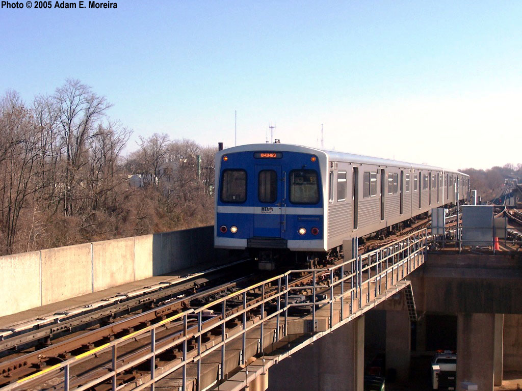
image_width = 250px
caption = Metro Subway train entering the Reisterstown Plaza station, bound for Owings Mills
type =Rapid transit
system =
status = Operational
locale =Baltimore, Maryland
start = Owings Mills (west)
end = Johns Hopkins Hospital (east)
stations = 14
routes =
ridership = 45,000 (daily)
open = 1983
close =
owner =Maryland Transit Administration
operator =Maryland Transit Administration
character = Underground and surface
stock = 100 Budd cars
linelength = 15.2 mi (24.5 km)
tracklength =
notrack = 2
gauge = RailGauge|sg (standard gauge )
el =Third rail
speed = convert|70|mph|abbr=on
elevation =
Baltimore Metro Green Line|The Metro Subway [Maryland Transit Administration , [http://www.mtamaryland.com/services/subway/general/ Metro Subway: General Information] , accessedApril 10 ,2007 ] or Baltimore Metro is a single-linerapid transit system serving the greaterBaltimore, Maryland ,United States area and operated by theMaryland Transit Administration . Despite its name, less than half of the line is underground; most of the line outside of the central city is elevated or at grade.History
The origins of the Metro Subway lie in a transit plan drawn up for the Baltimore area written in 1966 that envisioned six rapid transit lines radiating out from the city center. By the time this vision began to be translated into reality, construction costs in the United States had risen to the point of making transit construction prohibitively expensive, and there was less federal money available for transit projects than had been in the past and the plan was trimmed down to a single line. The southern half of the remaining line was never built because of crime concerns from residents of Anne Arundel County. When the Metro Subway finally opened in 1983, only this "Northwest" line of the 1966 plan had come to fruition. Service was provided between Charles Center in downtown Baltimore and Reisterstown Plaza in the northwest section of the city. (A decade later, much of the "North" and "South" lines of that plan would come into existence as the Baltimore Light Rail.)
In 1987, an extension from Reisterstown Road Plaza to Owings Mills in Baltimore County was added, much of it running in the median of I-795. In 1994, a further extension from Charles Center to
Johns Hopkins Hospital in Baltimore City was also opened. This last extension was an extremely truncated version of the 1966 plan's "Northeast" line.The current system is 15.2 miles (24.5 km) long, including convert|6.2|mi underground, convert|2.2|mi elevated, and convert|6.8|mi at grade.
Once the project was completed in 1994, the total cost for the Metro Subway was $1.392 billion.
Operation
Route
The Metro Subway's route consists of a single line in a shape that can be described as an extremely lopsided "U". Trains head due south underground from Johns Hopkins Hospital, turn west as they pass under Baltimore's central business district, then north and ultimately northwest towards Owings Mills. The route leaves its tunnel northwest of Mondawmin station, entering an elevated structure that parallels
Wabash Avenue and theWestern Maryland Railroad . The route eventually leaves the older railroad right of way to enter the I-795 median, which it occupies all the way to the system's Owings Mills terminus.Trains heading for Johns Hopkins Hospital are referred to as eastbound trains, while trains heading towards Owings Mills are said to be going west.
chedules
A trip from one end of the line to the other takes about half an hour. Headways range from 8 minutes during daytime peak to 11 minutes late at night, 15 minutes all day on weekends. Trains run from 5 a.m. to midnight on weekdays, 6 a.m. to midnight on weekends.
Fares
:"See: Current MTA Fares"
Connecting services
Most Metro Subway stations are served by a number of MTA bus routes; some routes, whose route numbers are prefixed with the letter "M", were drawn up specifically to serve as feeders for the Metro Subway. There is no direct connection to the Light Rail or to MARC — a fact that may strike the passenger as a distinct oversight in planning. The Metro Subway's Lexington Market Station is a convert|200|yd|sing=on walk from the Light Rail stop of the same name, and the State Center Station is about 1.5 blocks away from Light Rail's Cultural Center. In addition, MARC Penn Station is about a one-half mile walk from State Center, and MARC Camden Station is about five blocks from Lexington Market.
tations and connecting services
*Owings Mills (59 and M17 buses)
*Old Court (77 and M2 buses)
*Milford Mill (54 and M1 buses)
*Reisterstown Plaza (27, 56, 58 and 60 buses)
*Rogers Avenue (27, 33, 44, 51, 91, and M6 buses)
*West Coldspring (33, 51, and 97 buses)
*Mondawmin (1, 5, 7, 16, 22, 51, 97, M1, M2 and 54 buses)
*Penn-North (7, 13, 91, and 54 buses)
*Upton/Avenue Market (7 bus)
*State Center/Cultural Center (19, 21, 27, and 91 buses and Baltimore Light Rail's Cultural Center Station)
*Lexington Market (1, 5, 15, 19, 23, 27, and 91 buses and Baltimore Light Rail's Lexington Market Station)
*Charles Center (1, 3, 5, 8, 10, 11, 20, 23, 35, 36, 40, 64, and 91 buses and a two block walk to Baltimore Light Rail's Baltimore Street Station at Baltimore Street and Howard Street)
*Shot Tower/Market Place (7, 10, 20, 23, and 40 buses)
*Johns Hopkins Hospital (5, 13, and 35 buses)Rolling stock
Most of the Metro Subway's cars were manufactured by the
Budd Company Red Lion plant in Northeast Philadelphia in 1983, with a supplementary set of essentially identical cars being purchased in 1987 when the line expanded. The cars were marketed by Budd as theUniversal Transit Vehicle and are identical to those used on the Miami Metrorail, as the two systems were built at the same time, and the two agencies were able to save money by sharing a single order. Trains draw power from an electricthird rail . The cars are convert|72|ft|m long and convert|9.5|ft|m wide and have a top speed of over convert|70|mi/h|km/h|abbr=on. Cars are semi-permanently attached in married pairs, and 2-, 4-, and 6-car trains are all seen on the line. Each car can hold up to 166 passengers (76 seated, 90 standing).During 2003 and 2004, the Metro Subway fleet saw a significant overhaul. Car seats were replaced and the floors reupholstered. External destination rollsigns were replaced with LED displays, and internal systems that displayed and announced train destinations and upcoming stops were installed.
The MTA currently own 100 Metro Subway cars; approximately 54 are in use during peak weekday travel times.
Future
While the current Metro Subway is an important part of Baltimore's transit picture, the prohibitive cost of building new rapid transit lines — particularly the sort of underground lines that would be necessary in a densely populated area — have clouded prospects for future expansion. As of 2005, the state of Maryland is considering a new transit line, dubbed the Green Line, that would begin at the Metro Subway's Johns Hopkins Hospital terminus and run to the northeast corner of the city. If this line were implemented as an extension of the existing line, the entire Metro Subway might ultimately be rebranded as the Green Line (it is already colored green on MTA maps).
ee also
*
List of rapid transit systems References
External links
* [http://www.mtamaryland.com/services/subway/ The MTA's Metro Subway page]
* [http://www.roadstothefuture.com/Baltimore_Metro.html Scott Kozel's page on the Metro Subway]
Wikimedia Foundation. 2010.