- Maryland Route 607
-
Maryland Route 607
Route information Maintained by MDSHA Length: 1.54 mi[1] (2.48 km) Major junctions South end: Woods Road near Jacobsville  MD 100 in Jacobsville
 MD 177 in Jacobsville
North end: MD 100 in JacobsvilleHighway system Maryland highway system
Interstate • US • State • Minor • Former • Turnpikes←  MD 598
MD 610  →
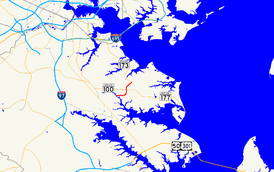
→Maryland Route 607 (MD 607) is a state highway in the U.S. state of Maryland. The state highway runs 1.54 mi (2.48 km) from the beginning of state maintenance south of MD 100 north to MD 173 in Jacobsville.
Contents
Route description
MD 607 begins as Magothy Bridge Road at an intersection with Woods Road and Seaborne Drive near Jacobsville. Magothy Bridge Road continues south and west as a county highway toward a crossing of the Magothy River and on to Pasadena. MD 607 heads north and temporarily becomes a two-lane divided highway around its intersection with MD 100 (Paul T. Pitcher Memorial Highway). The state highway continues north to the center of Jacobsville, where the road meets MD 173 (Mountain Road).[2] MD 607 continues north as Hog Neck Road to its northern terminus at MD 173 (Fort Smallwood Road).[1][2]
Junction list
The entire route is in Jacobsville in Anne Arundel County.
Mile
[1]Destinations Notes 0.00 Magothy Bridge Road south / Woods Road east Southern terminus 0.44 MD 100 (Paul T. Pitcher Memorial Highway) – Gibson Island, Glen Burnie0.78 MD 177 (Mountain Road) – Gibson Island, Pasadena1.54  MD 173 (Fort Smallwood Road) – Riviera Beach, Fort Smallwood
Northern terminus References
- ^ a b c "Highway Location Reference: Anne Arundel County" (PDF). Maryland State Highway Administration. 2008. http://apps.roads.maryland.gov/KeepingCurrent/performTrafficStudies/dataAndStats/hwyLocationRef/2008_hlr_all/co02.pdf. Retrieved 2010-06-04.
- ^ a b Google, Inc. Google Maps – Maryland Route 607 (Map). Cartography by Google, Inc. http://maps.google.com/maps?f=d&source=s_d&saddr=Magothy+Bridge+Rd&daddr=Hog+Neck+Rd&hl=en&geocode=FXDPVAIdaldw-w%3BFTgbVQIdvntw-w&mra=ls&sll=39.11681,-76.519518&sspn=0.030433,0.077162&ie=UTF8&ll=39.12227,-76.519003&spn=0.03043,0.077162&t=h&z=14. Retrieved 2010-06-04.
External links
Categories:- State highways in Maryland
- Roads in Anne Arundel County, Maryland

Wikimedia Foundation. 2010.