- Maryland Route 62
-
Maryland Route 62

Route information Maintained by MDSHA Length: 3.88 mi[1] (6.24 km) Major junctions South end:  MD 804 in Chewsville
North end:  MD 60 in Leitersburg
Location Counties: Washington Highway system Maryland highway system
Interstate • US • State • Minor • Former • Turnpikes←  MD 61
MD 61MD 63  →
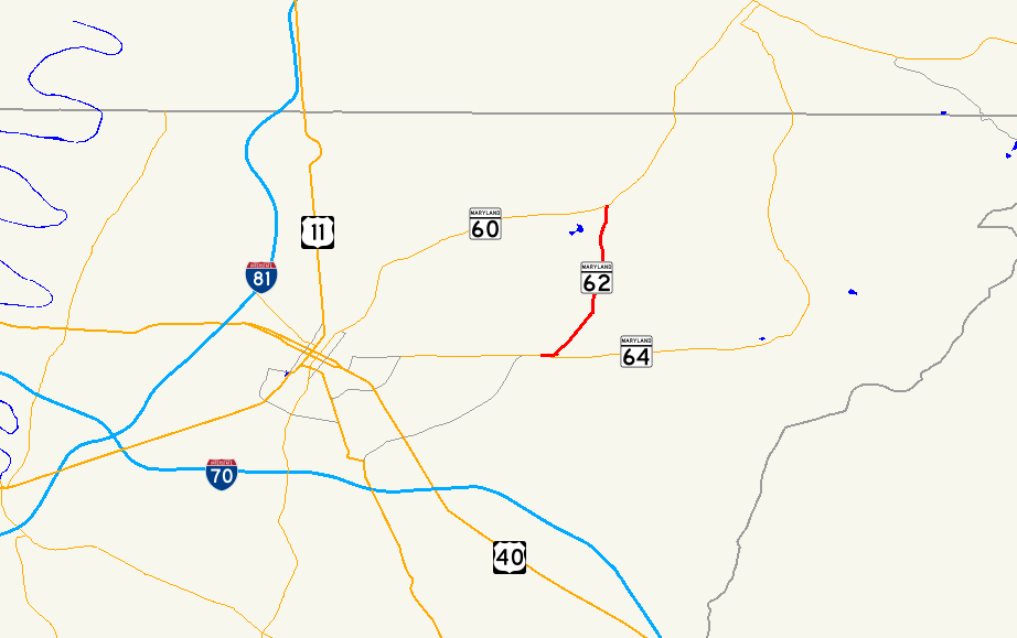
→Maryland Route 62 (MD 62) is a state highway in the U.S. state of Maryland. Known for most of its length as Little Antietam Road, the state highway runs 3.88 miles (6.24 km) from MD 804 in Chewsville north to MD 60 in Leitersburg in northeastern Washington County. MD 62 was constructed in two sections in the mid 1910s and the early 1930s.
Contents
Route description
MD 62 begins at an intersection with unsigned MD 804 in Chewsville. MD 804, the old alignment of MD 64 (Jefferson Boulevard), heads southwest as Trackside Drive to an intersection with MD 64 and east as Twin Springs Drive through the center of Chewsville. MD 62 heads west as two-lane Twin Springs Drive and immediately crosses CSX's Hanover Subdivision. The state highway heads west until it reaches Little Antietam Road, onto which the state highway turns northeast. MD 62 passes through a mix of farmland, forest, and scattered residences and veers north at Old Forge Road. The state highway passes the Good-Hartle Farm just before crossing Little Antietam Creek a short distance east of its confluence with Antietam Creek. MD 62 continues to its northern terminus at MD 60 (Leitersburg Pike) just west of Leitersburg.[1][2]
History
The first section of MD 62 was paved from Chewsville to Old Forge Road in 1916.[3] The remainder of the highway to Leitersburg was built in 1933.[4][5] MD 62 originally met MD 64 at its southern terminus.[6] After MD 64 bypassed Chewsville in 1956, the old alignment of MD 64 was designated MD 804B.[7]
Junction list
The entire route is in Washington County.
Location Mile[1] Destinations Notes Chewsville 0.00  MD 804 (Twin Springs Drive/Trackside Drive) to MD 64 – Smithsburg, Hagerstown
Southern terminus; MD 804 is old alignment of MD 64 0.39 Little Antietam Road south MD 62 turns north onto Little Antietam Road Leitersburg 3.88 MD 60 (Leitersburg Pike) – Hagerstown, WaynesboroNorthern terminus 1.000 mi = 1.609 km; 1.000 km = 0.621 mi References
- ^ a b c "Highway Location Reference: Washington County" (PDF). Maryland State Highway Administration. 2009. http://www.marylandroads.com/Location/2009_WASHINGTON.pdf. Retrieved 2010-11-21.
- ^ Google, Inc. Google Maps – Maryland Route 62 (Map). Cartography by Google, Inc. http://maps.google.com/maps?f=d&source=s_d&saddr=Twin+Springs+Dr&daddr=Little+Antietam+Rd&geocode=FXrnXAIdXVxf-w%3BFZ6hXQIdF4Ff-w&hl=en&mra=ls&sll=39.642908,-77.637047&sspn=0.000956,0.002411&ie=UTF8&ll=39.667028,-77.635231&spn=0.060652,0.154324&t=h&z=13. Retrieved 2010-11-21.
- ^ Report of the State Roads Commission of Maryland. 1916-1919. Baltimore: Maryland State Roads Commission. January 1920. p. 20. http://www.archive.org/details/annualreportsofs1916mary. Retrieved 2010-11-21.
- ^ Report of the State Roads Commission of Maryland. 1931-1934. Baltimore: Maryland State Roads Commission. 1934-12-28. p. 338. http://www.archive.org/details/reportofstateroa1931mary. Retrieved 2010-11-21.
- ^ Maryland Geological Survey. Map of Maryland Showing State Road System: State Aid Roads and Improved County Road Connections (Map) (1933 ed.).
- ^ Maryland State Roads Commission. Maryland: Official Highway Map (Map) (1955 ed.).
- ^ Report of the State Roads Commission of Maryland. 1955-1956. Baltimore: Maryland State Roads Commission. 1956-11-02. p. 193. http://www.archive.org/details/reportofstateroa1955mary. Retrieved 2010-11-21.
External links
Roads in Washington County, Maryland State highways 
U.S. Highways Interstate Highways Categories:- State highways in Maryland
- Roads in Washington County, Maryland


Wikimedia Foundation. 2010.