- Maryland Route 586
-
Maryland Route 586
Veirs Mill Road 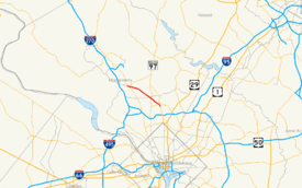
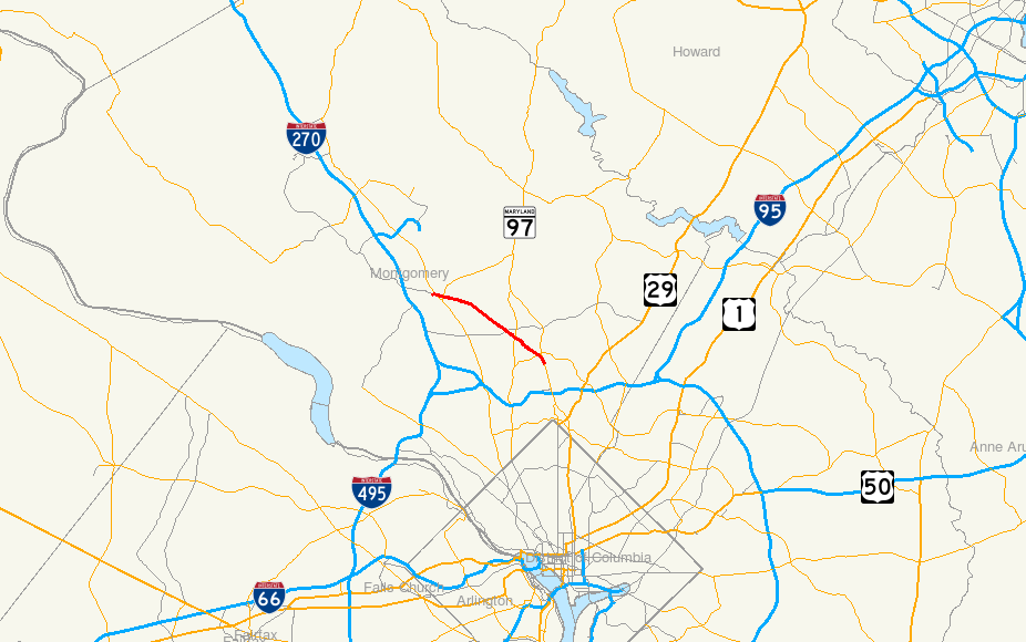
Maryland Route 586 highlighted in redRoute information Maintained by MDSHA Length: 5.78 mi[1] (9.30 km) Major junctions North end:  MD 28 in Rockville
Randolph Road in Wheaton
 MD 185 in Wheaton
 MD 193 in Wheaton
South end:  MD 97 in Wheaton
Highway system Maryland highway system
Interstate • US • State • Minor • Former • Turnpikes←  MD 579
MD 587  →
→Maryland Route 586 (MD 586) is a state highway in the U.S. state of Maryland. Known as Veirs Mill Road, the state highway runs 5.78 mi (9.30 km) from MD 28 in Rockville east to MD 97 in Wheaton.
Contents
Route description
 MD 586 looking east at the crossing of Turkey Branch
MD 586 begins at an intersection with MD 28 and MD 911 in Rockville. Veirs Mill Road continues west as MD 28 west, which heads toward downtown Rockville and provides access to northbound MD 355. First Street heads north as eastbound MD 28 and south as MD 911, which provides a connection to southbound MD 355.[2] MD 586 heads southeast as a four-lane divided highway flanked by service roads on both sides that serve the dense residential subdivisions between which the highway passes.[1][2] The service roads end at the eastern limits of Rockville, where the state highway intersects Twinbrook Parkway and crosses Rock Creek.[1] After intersecting Aspen Hill Road, MD 586 passes between Rock Creek Regional Park on the south and the southwestern edge of the residential subdivisions of Aspen Hill on the north. Residential subdivisions surround the highway on both sides again shortly before the highway crosses Turkey Branch.[2] MD 586 expands to six lanes shortly before its intersection with Randolph Road.[1]
MD 586 continues southeast between densely-populated residential subdivisions in Wheaton.[2] The state highway intersects MD 185 (Connecticut Avenue) at an acute angle and reduces to four full-use lanes at Newport Mill Road, with a combination right-turn and bus lane in the eastbound direction. The westbound direction gains a third lane shortly before MD 586 enters downtown Wheaton and intersects MD 193. The state highway continues southeast with five lanes as it passes between the Wheaton Plaza shopping mall on the west and the Wheaton Metro Station on the east.[1][2] MD 586 reaches its southern terminus at a directional intersection with MD 97 (Georgia Avenue). There is no access between MD 586 east and MD 97 north.[2]
History
MD 586 is named after a water-powered grist and sawmill on Rock Creek built by Samuel Clark Veirs in 1838 and operated by his family until 1924.[3]
Junction list
The entire route is in Montgomery County.
Location Mile
[1]Destinations Notes Rockville 0.00  MD 28 west (Veirs Mill Road) to MD 355 north – Gaithersburg
Western terminus  MD 28 east / MD 911 south (First Street) to MD 355 south – Norbeck, North Bethesda
Wheaton 3.48 Randolph Road – North Bethesda, Glenmont 4.01 MD 185 (Connecticut Avenue) – Kensington, Aspen Hill5.36 MD 193 (University Boulevard) – Kensington, Silver Spring5.78 MD 97 south (Georgia Avenue) – Forest Glen, Silver SpringEastern terminus; no access from eastbound MD 586 to northbound MD 97 References
- ^ a b c d e f "Highway Location Reference: Montgomery County" (PDF). Maryland State Highway Administration. 2008. http://apps.roads.maryland.gov/KeepingCurrent/performTrafficStudies/dataAndStats/hwyLocationRef/2008_hlr_all/co15.pdf. Retrieved 2010-05-24.
- ^ a b c d e f Google, Inc. Google Maps – Maryland Route 586 (Map). Cartography by Google, Inc. http://maps.google.com/maps?f=d&source=s_d&saddr=Veirs+Mill+Rd&daddr=Veirs+Mill+Rd&hl=en&geocode=FShPVAIdPPhm-w%3BFUGkUwIdX09o-w&mra=ls&sll=39.057845,-77.09394&sspn=0.060917,0.154324&ie=UTF8&t=h&z=13. Retrieved 2010-05-24.
- ^ Historical Marker Database: Veirs Mill
External links
Roads in Montgomery County, Maryland Maryland State Highways 
U.S. Routes Interstate Highways Roads by name Cabin John Parkway · Clara Barton Parkway · Cherry Hill Road · Connecticut Avenue · Georgia Avenue · Montrose Road · New Hampshire Avenue · Randolph Road · Sligo Creek Parkway · Wisconsin Avenue · 16th StreetCategories:- State highways in Maryland
- Roads in Montgomery County, Maryland


Wikimedia Foundation. 2010.