- Maryland Route 195
-
This article describes a Maryland state highway numbered 195. For the Interstate with the same number, see Interstate 195 (Maryland).
Maryland Route 195
Carroll Avenue 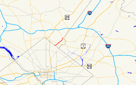
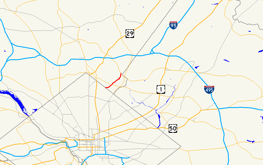
Route information Maintained by MDSHA and City of Takoma Park Length: 1.90 mi[1] (3.06 km) Major junctions South end: Carroll Street in Washington, D.C.  MD 787 in Takoma Park
North end:  MD 193 in Takoma Park
Highway system Maryland highway system
Interstate • US • State • Minor • Former • Turnpikes←  I-195
I-195MD 196  →
→Maryland Route 195 is a state highway in the U.S. state of Maryland. Known as Carroll Avenue, the state highway runs 1.90 mi (3.06 km) from Eastern Avenue at the border of Washington, D.C. north to Maryland Route 193 in Takoma Park. MD 195 provides access to Washington Adventist University, Washington Adventist Hospital, the Takoma Park Historic District, and the Takoma station of the Washington Metro just south of the border in Washington. The state highway was finished in the late 1920s but its most notable feature, the Carroll Avenue Bridge over Sligo Creek, was completed in 1932.
Contents
Route description
Maryland Route 195 begins at the border of Washington, D.C. at an intersection with Eastern Avenue. The road continues west as Carroll Street into the Takoma neighborhood of Washington, where it provides access to the Takoma station on the Red Line of the Washington Metro. [2] MD 195 heads east as a two-lane street with a speed limit of 25 mph (40 km/h) through the Takoma Park Historic District.[1] At Laurel Avenue, which is closed for the Takoma Park Farmers Market every Sunday, the state highway turns north to continue on Carroll Avenue through businesses and closely spaced residences within Old Town Takoma Park.[3] After passing a pedestrian traffic signal at Tulip Avenue, the state highway turns north toward Takoma Junction. At Takoma Junction, MD 195 intersects Maryland Route 410 (Philadelphia Avenue) at the Takoma Park Volunteer Fire Department and joins that state highway in a concurrency. After 400 feet (120 m), the two routes diverge, with MD 410 heading east and MD 195 heading north.
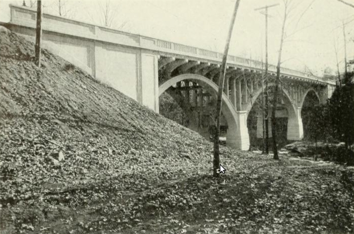
MD 195 continues north through a residential area. At Lincoln Avenue, the state highway turns northeast and starts heading downhill into the valley of Sligo Creek. Where Old Carroll Street continues straight down the hill to access Sligo Creek Parkway, MD 195 veers north and crosses the parkway, the creek, and the Sligo Creek Trail on the Carroll Avenue Bridge, a triple span reinforced concrete, open spandrel arch bridge completed in 1932.[4][5] The state highway heads through a moderate S-curve in which it passes the main entrance to Washington Adventist Hospital and adjoins the campus of Washington Adventist University, then intersects Maryland Route 787 (Flower Avenue).[2]
After crossing MD 787, MD 195 leaves the university campus and heads downhill northeast toward Long Branch, a tributary of Northwest Branch. The state highway is maintained for 0.21 miles (0.34 km) by the city of Takoma Park between MD 787 and the city limit north of Garland Avenue.[1] After leaving the corporate limits, the speed limit increases to 30 mph (48 km/h).[1] At the bottom of the hill, MD 195 intersects Long Branch Parkway at a flashing signal and crosses the stream on a bridge rebuilt in 2005, then heads uphill and curves north.[4] Between Glenside Drive and Chester Street, the state highway parallels unsigned MD 195A, a service road for adjoining residences.[1] After passing Chester Street, MD 195 acquires a narrow grassy median for short stretches on the way to its northern terminus.[2] After passing the Davis-Warner House and Merrimac Drive, the state highway reaches its north end at an oblique intersection with Maryland Route 193 (University Boulevard).[2] Since a left turn is prohibited from MD 193 west to MD 195 south, Merrimac Drive is used for that missing connection. Carroll Avenue continues north as a county-maintained street that ends at Maryland Route 320 (Piney Branch Road).[2]
MD 195 has an average annual daily traffic figure of 9892 vehicles between Laurel Avenue and MD 410, as well as an AADT of 13912 between Long Branch Parkway and MD 193.[6]
History
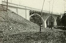 Carroll Avenue Bridge in the early 1930s
Portions of Carroll Avenue date back to 1878, when the first bridge crossing Sligo Creek in the area was built just to the east of the present bridge.[5] This bridge was part of an old road between Washington and Sandy Spring that roughly followed present day MD 195, MD 320, and MD 650 north to Ashton.[7] The street itself was named for Samuel S. Carroll, the owner of the land around present day Takoma Junction prior to its purchase by Benjamin Franklin Gilbert in 1883 to create his planned suburb of Takoma Park.[7] A reinforced concrete bridge over Sligo Creek was built on the location of the present bridge in 1909, connecting Washington and the Washington Sanatarium, which had been completed in 1907.[5] MD 195 was paved between 1927 and 1930 along its entire length, including the city-maintained portion north of Flower Avenue.[8][9] The 1909 bridge over Sligo Creek was replaced by the current bridge in 1932.[5][10]
Junction list
The entire route is in Takoma Park in Montgomery County.
Mile[1] Destinations Notes 0.00 Eastern Avenue Southern terminus Road continues into Washington as Carroll Street
0.08 Laurel Avenue MD 195 turns north to remain on Carroll Avenue 0.44  MD 410 west (Philadelphia Avenue) – Silver Spring
Begin concurrency with MD 410 0.52 MD 410 east (Ethan Allen Avenue) – HyattsvilleEnd concurrency with MD 410 1.00 Carroll Avenue Bridge over Sligo Creek 1.14 MD 787 west (Flower Avenue) – Silver Spring1.90 MD 193 (University Boulevard) – Silver Spring, Langley ParkNorthern terminus Carroll Avenue continues north
References
- ^ a b c d e f "Highway Location Reference: Montgomery County" (PDF). Maryland State Highway Administration. 2008. http://apps.roads.maryland.gov/KeepingCurrent/performTrafficStudies/dataAndStats/hwyLocationRef/2008_hlr_all/co15.pdf. Retrieved 2010-01-29.
- ^ a b c d e Google, Inc. Google Maps – Maryland Route 195 (Map). Cartography by Google, Inc. http://maps.google.com/maps?f=d&source=s_d&saddr=md-195+and+eastern+ave+takoma+park,+md&daddr=md-195+and+md-193+takoma+park,+md&hl=en&geocode=FUu1UgIdRtxo-ynDjockg8i3iTHiQw5imqwXNQ%3BFbwAUwIdyi9p-ynt64f5Dca3iTFkuWsaB76lxA&mra=ls&sll=38.976693,-77.009332&sspn=0.007623,0.01929&ie=UTF8&t=h&z=14. Retrieved 2010-01-29.
- ^ "Takoma Park Farmers Market". Takoma Park Farmers Market. http://www.takomaparkmarket.com/. Retrieved 2010-01-29.
- ^ a b Svirsky, Alexander. "National Bridge Inventory Database". http://nationalbridges.com/. Retrieved 2010-01-29.
- ^ a b c d "Historic Bridges Over Sligo Creek". Friends of Sligo Creek. http://www.fosc.org/SligoBridges.htm. Retrieved 2010-01-29.
- ^ "Traffic Volume Maps" (PDF). Maryland State Highway Administration. 2008. http://apps.roads.maryland.gov/shaservices/mapsbrochures/maps/oppe/trafficvolumemaps/2008/Traffic_Volume_Maps.pdf. Retrieved 2010-01-29.
- ^ a b "History of Takoma Park". Main Street Takoma. http://www.mainstreettakoma.org/page/history. Retrieved 2010-01-29.
- ^ Maryland State Highway Administration (JPG). Map of Maryland (Map) (1927 ed.). http://www.mdhighwaycentennial.com/images/template/gallery/maps/1927SIDE1.jpg. Retrieved 2010-01-29.
- ^ Maryland State Highway Administration (JPG). Map of Maryland (Map) (1930 ed.). http://commons.wikimedia.org/wiki/File:Maryland_State_Highway_Map_-_1930.jpg. Retrieved 2010-01-29.
- ^ Report of the State Roads Commission of Maryland. 1931-1934. Baltimore: Maryland State Roads Commission. 1934-12-28. p. 44. http://www.archive.org/details/reportofstateroa1931mary. Retrieved 2010-01-29.
External links
Roads in Montgomery County, Maryland Maryland State Highways 
U.S. Routes Interstate Highways Roads by name Cabin John Parkway · Clara Barton Parkway · Cherry Hill Road · Connecticut Avenue · Georgia Avenue · Montrose Road · New Hampshire Avenue · Randolph Road · Sligo Creek Parkway · Wisconsin Avenue · 16th StreetCategories:- State highways in Maryland
- Roads in Montgomery County, Maryland


Wikimedia Foundation. 2010.