- Clara Barton Parkway
-
Clara Barton Parkway 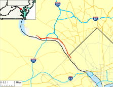
Route information Maintained by NPS Length: 6.8 mi[1] (10.9 km) Major junctions West end: MacArthur Boulevard in Potomac, Maryland
Cabin John Parkway in Cabin John I-495 in Carderock, Maryland
East end: Canal Road in Washington, D.C. Highway system Numbered highways in Washington, D.C.
Maryland highway system
Interstate • US • State • Minor • Former • TurnpikesThe Clara Barton Parkway is a highway in Washington, D.C. and neighboring Montgomery County, Maryland. It is administratively part of the George Washington Memorial Parkway. It was signed as the George Washington Memorial Parkway until 1989, when it was renamed to avoid motorist confusion.[2] It is named in honor of Clara Barton, founder of the American Red Cross.
The parkway's eastern terminus (38°55′49.45″N 77°6′42.92″W / 38.9304028°N 77.1119222°W) is in the District of Columbia, where the parkway connects with Canal Road and Chain Bridge. Its western terminus (38°58′42.7″N 77°12′24.04″W / 38.978528°N 77.2066778°W) is at MacArthur Boulevard in the Potomac area of Montgomery County, Maryland, just outside the Capital Beltway. The parkway provides access to Glen Echo Park and the Clara Barton National Historic Site in Glen Echo, Maryland. The parkway connects to the Capital Beltway via a partial interchange and also via the Cabin John Parkway (administered by the Maryland State Highway Administration). The parkway includes an overhanging bridge near Glen Echo.
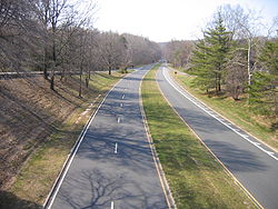
One section of the parkway serves one-way traffic during weekday rush hours, permitting only southbound traffic to Washington in the morning and northbound traffic to Maryland in the afternoon.
Contents
Planned connection
 The Clara Barton Parkway in Maryland
The parkways on each side of the Potomac River were originally supposed to be joined by a bridge at the Great Falls. However, opposition from preservationists led to the cancellation of that bridge. Instead, traffic between the two parkways uses the American Legion Bridge of the Capital Beltway. The Virginia side of the river at Great Falls is managed by the superintendent of the parkway as a national park, known as Great Falls Park. Some elements of the proposed final parkway configuration were built but have never been used, such as the concrete bridge that would have carried northbound traffic at the Glen Echo turnaround. It remains in place over the roadway, but its surface is covered by grass and it connects only to a wooded area along MacArthur Boulevard.
Route description
Clara Barton Parkway begins at an intersection with MacArthur Boulevard in Carderock. MacArthur Boulevard heads west toward Great Falls and the affluent community of Potomac. Clara Barton Parkway heads east as a two-lane highway, expanding to a four-lane divided highway immediately before a diamond interchange with an access road to the Carderock Division of the Naval Surface Warfare Center to the north, which features the David Taylor Model Basin, and Carderock Recreation Area of the C&O Canal to the south. East of the NSWC property, the two roadways split for the parkway's interchange with I-495 (Capital Beltway), which is similar to a trumpet interchange with extra flyover ramps. There is no direct access from westbound Clara Barton Parkway to northbound I-495 or from southbound I-495 to the eastbound parkway.[1]
The parkway roadways come together in Cabin John just west of parking areas accessible from the eastbound direction to C&O Canal Lock 10 and C&O Canal Lock 8 and River Center. Access to a MacArthur Boulevard in Cabin John is provided by a diamond interchange to a road connecting the highway with the parkway. Clara Barton Parkway reduces to one lane eastbound as it crosses Cabin John Creek and meets Cabin John Parkway at a partial interchange featuring ramps from westbound Clara Barton Parkway to northbound Cabin John Parkway and an entrance from Cabin John Parkway to eastbound Clara Barton Parkway, which becomes two lanes again. The westbound lanes are elevated on top of a retaining wall above the eastbound lanes through interchange with an access road to MacArthur Boulevard in Glen Echo, which is the location of Glen Echo Park and Clara Barton National Historic Site. The interchange features a tight hairpin-turn ramp from eastbound to westbound parkway, a tight right-turn ramp from the access road to the westbound parkway, and an unused bridge over the westbound direction.[1]
East of Glen Echo, Clara Barton Parkway reduces to a two-lane undivided highway that closely parallels MacArthur Boulevard on the hillside to the north. The parkway passes a pair of parking areas for Little Falls before expanding to a four-lane divided highway while passing a third parking area for C&O Canal Lock 6. Clara Barton Parkway reduces to a two-lane undivided highway again as it passes under a pedestrian bridge. The parkway crosses Little Falls Branch and enters the District of Columbia before reaching its east terminus at an intersection with Canal Road and Chain Bridge Road. Canal Road heads east toward Georgetown while Chain Bridge Road crosses Chain Bridge into Arlington, Virginia to connect with Virginia State Route 120 and VA 123.[1]
Junction list
Jurisdiction Location Mile[1] Destinations Notes Montgomery County, Maryland Carderock 0.0 MacArthur Boulevard – Great Falls, Potomac Western terminus 0.7 Carderock Division of the Naval Surface Warfare Center Diamond interchange 1.6 I-495 (Capital Beltway) – Baltimore, Tysons CornerNo direct access from southbound I-495 to eastbound Clara Barton Parkway and from westbound Clara Barton Parkway to northbound I-495 Cabin John 3.1 MacArthur Boulevard – Cabin John Diamond interchange 3.5 Cabin John Parkway to I-495 north – BaltimoreWestbound exit and eastbound entrance Glen Echo 4.2 MacArthur Boulevard – Glen Echo No access from access road to eastbound Clara Barton Parkway Washington, D.C. 6.8 Chain Bridge Road south to  SR 123 / Canal Road east – Georgetown, Arlington
Eastern terminus 1.000 mi = 1.609 km; 1.000 km = 0.621 mi References
- ^ a b c d e Google, Inc. Google Maps – Clara Barton Parkway (Map). Cartography by Google, Inc. http://maps.google.com/maps?f=d&source=s_d&saddr=Clara+Barton+Pkwy&daddr=38.930342,-77.111818&hl=en&geocode=FRTEUgIdzOtl-w%3BFaYHUgId9l1n-w&mra=ls&sll=38.978198,-77.206158&sspn=0.001914,0.004823&ie=UTF8&t=h&z=13. Retrieved 2010-11-15.
- ^ Shaffer, Ron (June 25, 2006). "After 20 Years of Columns, Checking the Rearview Mirror One Last Time". The Washington Post: p. C01. http://www.washingtonpost.com/wp-dyn/content/article/2006/06/24/AR2006062400980.html.
Roads in Montgomery County, Maryland Maryland State Highways 
U.S. Routes Interstate Highways Roads by name Cabin John Parkway · Clara Barton Parkway · Cherry Hill Road · Connecticut Avenue · Georgia Avenue · Montrose Road · New Hampshire Avenue · Randolph Road · Sligo Creek Parkway · Wisconsin Avenue · 16th StreetCoordinates: 38°58′22.76″N 77°10′5.46″W / 38.9729889°N 77.1681833°W
Categories:- United States federal parkways
- Roads in Maryland
- Streets in Washington, D.C.
- Roads in Montgomery County, Maryland
- United States National Park Service areas in Washington, D.C.
- United States National Park Service areas in Maryland


Wikimedia Foundation. 2010.