- George Washington Memorial Parkway
-
George Washington Memorial Parkway Route information Maintained by NPS Existed: 1930 – present Major junctions South end:  SR 235 near Mount Vernon, Virginia
 SR 400 in Alexandria, Virginia (gap in route)

 I-395 / US 1 in Arlington, Virginia
North end:
 SR 27 in Washington, D.C.

 I-66 / US 50 in Arlington, Virginia
 US 29 in Arlington, Virginia
 SR 123 in Arlington, Virginia
 I-495 in McLean, Virginia
Highway system Numbered highways in Washington, D.C.
Virginia Routes
Primary • Secondary • History • TurnpikesGeorge Washington Memorial Parkway IUCN Category V (Protected Landscape/Seascape)

Location Virginia, Washington, D.C. & Maryland, USA Nearest city Washington, D.C. Coordinates 38°54′40″N 77°06′08″W / 38.91111°N 77.10222°WCoordinates: 38°54′40″N 77°06′08″W / 38.91111°N 77.10222°W Area 7,247 acres (29 km2) Established May 29, 1930 Visitors 7,284,165 (in 2005) Governing body National Park Service 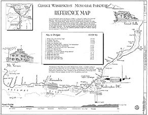 Map of the George Washington Memorial Parkway
The George Washington Memorial Parkway, known to local motorists simply as the "G.W. Parkway", is a parkway maintained by the U.S. National Park Service. It is located mostly in Northern Virginia, although a short section northwest of the Arlington Memorial Bridge passes over Columbia Island, which is within the District of Columbia. It is separated into two sections joined by Washington Street (Virginia State Route 400) in Alexandria, Virginia. A third section, the Clara Barton Parkway, runs on the opposite side of the Potomac River in the District of Columbia and Montgomery County, Maryland. A fourth section was proposed for Fort Washington, Maryland, but never built. The parkway is designated an All-American Road.
Contents
Northern section
The northern section extends from North Washington Street at First Street, at the northern end of Old Town Alexandria, to its terminus at Interstate 495, the Capital Beltway, in Fairfax County, just south of the Potomac River. It follows the Potomac River, passing through Arlington County, and serves as the primary access point to Ronald Reagan Washington National Airport. The parkway also provides automobile access to Theodore Roosevelt Island, the LBJ National Grove, Gravelly Point Park, Fort Marcy, Columbia Island Marina and Turkey Run Park. There are scenic view rest areas for those wishing to view the Georgetown skyline and Potomac Palisades. The cloverleaf interchange with the 14th Street Bridge, dating to 1932, is one of the oldest cloverleaf interchanges in the United States. Spout Run Parkway connects the George Washington Memorial Parkway to U.S. Route 29, providing an indirect connection to Interstate 66. The portion of the parkway north of National Airport and State Route 233 is part of the National Highway System.
Southern section
Washington Street in Alexandria is owned by the National Park Service as part of the parkway, and leased to the city for maintenance.[citation needed] A majority of the park along the Alexandria shore line is also leased land.[citation needed]
The southern section extends from South Washington Street at the southern end of Old Town Alexandria past Fort Hunt to Mount Vernon. The southern section is a limited-access highway, but with at-grade intersections. At Mount Vernon, the parkway ends at a traffic circle, where it joins State Route 235. Most of this route was taken from the Washington, Alexandria and Mount Vernon Railway's right-of-way. The Mount Vernon bicycle trail parallels the southern and middle sections of the parkway (from Theodore Roosevelt Island to Mount Vernon), and is often filled with recreational and commuter cyclists and runners. Points of interest on or near the parkway are the Woodrow Wilson Bridge, Jones Point, Hunting Creek, Dyke Marsh, Fort Hunt Park, P. O. Box 1142, Huntley Meadows Park, and Mount Vernon.
Clara Barton Parkway
Main article: Clara Barton ParkwayThe Clara Barton Parkway is administratively part of the George Washington Memorial Parkway. It was signed as the George Washington Memorial Parkway until 1989, when it was renamed to overcome motorist confusion.[1]
The Clara Barton Parkway has its eastern terminus in the District of Columbia, where the parkway connects with Canal Road and Chain Bridge. Its western terminus is at MacArthur Boulevard in the Potomac area of Montgomery County, Maryland, just outside the Capital Beltway. The parkway provides access to Glen Echo Park and the Clara Barton National Historic Site in Glen Echo, Maryland. The Clara Barton Parkway connects to the Capital Beltway via a partial interchange and also via the Cabin John Parkway (administered by the Maryland State Highway Administration). The Clara Barton Parkway includes an overhanging bridge near Glen Echo.
Previously proposed connection
The parkways on the two sides of the river were originally supposed to be joined by a bridge at the Great Falls of the Potomac River. However, opposition from preservationists led to the cancellation of that bridge. Instead, traffic between the two parkways uses the American Legion Bridge. The Virginia side of the Potomac river at Great Falls is managed by the Superintendent of the parkway as a national park site, known as Great Falls Park. Some elements of the proposed final parkway configuration – such as the concrete bridge that would have carried northbound traffic at the Glen Echo turn-around – were built but have never been used.[citation needed]
Administrative history
The parkway was authorized May 29, 1930 and transferred from the Office of Public Buildings and Public Parks of the National Capital August 10, 1933. On November 28, 1989, the portion in Maryland was renamed the Clara Barton Parkway. The Parkway also administers other National Park Service features and areas:
- Arlington House, The Robert E. Lee Memorial
- Arlington Memorial Bridge
- Clara Barton National Historic Site
- Claude Moore Colonial Farm
- Columbia Island Marina
- Dyke Marsh
- Fort Marcy
- Glen Echo Park
- Gravelly Point
- Great Falls Park
- Lady Bird Johnson Park
- Lyndon Baines Johnson Memorial Grove on the Potomac
- Mount Vernon Trail
- Navy-Marine Memorial
- Netherlands Carillon
- Theodore Roosevelt Island
- Turkey Run Park
- USMC War Memorial
- Women in Military Service for America Memorial
Major intersections
Only interchanges and signalized intersections are listed.[2]
Location Exit Name Notes 1 SR 235 (Mount Vernon Memorial Highway)Traffic circle 2 Fort Hunt Road - Fort Hunt Park Interchange 3 Hunting Creek Bridge; south end of gap Gap; see State Route 400 4 1st Street North end of gap 5 Bashford Lane 6 Slaters Lane 7 Reagan National Airport Interchange 8 I-395 - Washington, RichmondSigned as exits 8A (north) and 8B (south) 9 SR 27 west to I-395 – Lyndon B. Johnson Memorial Grove, PentagonInterchange; no northbound exit 10 Arlington Memorial Bridge - Arlington National Cemetery, Washington Interchange 11 US 50 westInterchange; northbound exit and southbound entrance 12 I-66 east / US 50 eastInterchange; southbound exit and northbound entrance 13 US 29 north - Key BridgeInterchange; southbound exit and northbound entrance 14 To I-66 west to US 29 / Spout Run Parkway – Arlington, WashingtonInterchange; northbound exit and southbound entrance 15 SR 123 – Chain Bridge, Washington, McLeanInterchange 16 CIA, Federal Highway Administration Interchange 17 Turkey Run Park, Washington, to I-495 (U-turn) Interchange 18 I-495 - Virginia / MarylandInterchange; signed as exits 18A (south) and 18B (north) Photos from the George Washington Memorial Parkway 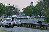 Vehicles round a bend in the George Washington Parkway near Reagan National Airport and Gravelly Point in Arlington, Va.
 Portion of the Potomac Heritage Trail as it passes through marshland near Belle Haven
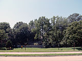
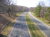
 Houses along the parkway near Mount Vernon
 Aerial overview
References
- ^ Ron Shaffer (June 25, 2006). "After 20 Years of Columns, Checking the Rearview Mirror One Last Time". The Washington Post. http://www.washingtonpost.com/wp-dyn/content/article/2006/06/24/AR2006062400980.html. Retrieved 2007-11-23.
- ^ Google Maps aerial photos; the stop line at traffic signals is clearly visible
External links
- National Park Service: George Washington Memorial Parkway
- History of the George Washington Memorial Parkway
- Steve Anderson's DCRoads.net: George Washington Memorial Parkway
- The National Parks: Index 2001-2003. Washington: U.S. Department of the Interior.
U.S. National Register of Historic Places Topics Lists by states Alabama • Alaska • Arizona • Arkansas • California • Colorado • Connecticut • Delaware • Florida • Georgia • Hawaii • Idaho • Illinois • Indiana • Iowa • Kansas • Kentucky • Louisiana • Maine • Maryland • Massachusetts • Michigan • Minnesota • Mississippi • Missouri • Montana • Nebraska • Nevada • New Hampshire • New Jersey • New Mexico • New York • North Carolina • North Dakota • Ohio • Oklahoma • Oregon • Pennsylvania • Rhode Island • South Carolina • South Dakota • Tennessee • Texas • Utah • Vermont • Virginia • Washington • West Virginia • Wisconsin • WyomingLists by territories Lists by associated states Other Streets and highways of Washington, D.C. Streets 7th St. • 14th St. NW/SW • 16th St. NW • 18th St. NW • E. Capitol St. • N. Capitol St. • S. Capitol St. • H St. • Jackson Place • K St. • M St. • Madison Place • U St.Avenues,
Roads & DrivesBenning Rd. • Canal Rd. • Connecticut Ave. • Constitution Ave. • Eastern Ave. • Florida Ave. • Georgia Ave. • Independence Ave. • Klingle Road • Maine Ave. • Martin Luther King, Jr. Ave.• Massachusetts Ave. • New Hampshire Ave. • New York Ave. • Ohio Dr. • Pennsylvania Ave. • Rhode Island Ave. • Southern Ave. • Virginia Ave. • Wisconsin Ave.Circles Anna J. Cooper Circle • Barney Circle • Benjamin Banneker Circle • Columbus Circle • Dupont Circle • Garfield Circle • Grant Circle • Logan Circle • Observatory Circle • Peace Circle • Pinehurst Circle • Randle Circle • Scott Circle • Sheridan Circle • Sherman Circle • Tenley Circle • Thomas Circle • Ward Circle • Washington Circle • Westmoreland CircleHighways Anacostia Frwy. • Clara Barton Pkwy. • E St. Expy. • G.W. Pkwy. • I-66 • I-295 • I-395 • I-495 • Rock Creek & Potomac Pkwy. • Southeast Frwy. • Suitland Pkwy. • Whitehurst Frwy.Categories:- IUCN Category V
- 1930 establishments
- All-American Roads
- Roads in Montgomery County, Maryland
- United States federal parkways
- Transportation in Fairfax County, Virginia
- Transportation in Alexandria, Virginia
- Transportation in Arlington County, Virginia
- Transportation in Washington, D.C.
- Arlington County Historic Districts
- Roads on the National Register of Historic Places in Washington, D.C.
- Roads on the National Register of Historic Places in Maryland
- Roads on the National Register of Historic Places in Virginia
- United States National Park Service areas in Maryland
- United States National Park Service areas in Virginia
- United States National Park Service areas in Washington, D.C.


Wikimedia Foundation. 2010.