- Prince William Forest Park
-
Prince William Forest Park IUCN Category III (Natural Monument)Location Prince William County, Virginia, USA Nearest city Dumfries, Virginia Coordinates 38°35′07″N 77°22′47″W / 38.58528°N 77.37972°WCoordinates: 38°35′07″N 77°22′47″W / 38.58528°N 77.37972°W Area 16,084 acres (6,509 ha) Established November 14, 1936 Visitors 386,521 (in 2010) Governing body National Park Service Prince William Forest Park was established as Chopawamsic Recreational Demonstration Area in 1936 and is located in southeastern Prince William County, Virginia,[1] adjacent to the Marine Corps Base Quantico. The park is the largest protected natural area in the Washington, D.C. metropolitan region at over 19,000 acres (7,700 ha). Today, the park is a window into the past and serves as an example of what much of the East Coast once looked like centuries ago.
The park serves as the largest example of Eastern Piedmont forest in the National Park System (arguably, one of the most heavily altered ecosystems in North America). The park also protects the Quantico Creek watershed. It is a sanctuary for numerous native plant and animal species.
Contents
Recreational opportunities
A variety of recreational opportunities are available, which include:
- Wildlife viewing
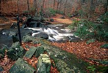
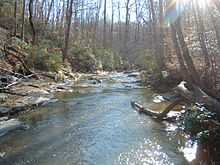
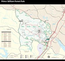
- 37 miles (60 km) of hiking trails. Most of these trails either go to a historical/cultural destination such as Pyrite Mine or follow Quantico Creek with views of its small waterfalls.
- 21 miles (34 km) of bicycle accessible roads and trails.
- Several tent camping options, including family, group and backcountry camping are available as well as rustic cabin camping, and a full-service, concessionaire-operated RV campground, are available.
Cultural resources
The park’s cultural resources are also varied. They include:
- The remnants of Joplin, Hickory Ridge, and Batestown, three small communities existing prior to the park’s establishment
- The reclaimed remnants of the Cabin Branch Pyrite Mine along Quantico Creek
- The reclaimed remnants of the Greenwood gold mine[2]
- Products of the Civilian Conservation Corps (CCC), which built the facilities, roads and lakes during the 1930s
- The U.S. Army’s Office of Strategic Services (OSS) which used the land exclusively for training spies and radio operators between 1942 and 1945
Known Wildlife
Tortoise such as the eastern box turtle can be found in Prince William Forest Park, especially after a light rain. True toads can also be spotted in the park, with best luck for seeing them is in the early morning hours of early afternoon along wooded trails near areas that have an insect population. The park is also home to red tail foxes and white tail deer; spotted along the upper North Valley Trail. A few black rat snakes have been seen in and around logs and brush areas. Various skinks can be seen around sunny areas of the trails. Hawks inhabit the park and have been spotted hunting along the creeks.
See also
References
- ^ National Park Service - Chopawamsic Recreational Demonstration Area
- ^ Jeff Wynn, "A Ground Electromagnetic Survey Used to Map Sulfides and Acid Sulfate Ground Waters at the Abandoned Cabin Branch Mine, Prince William Forest Park, Northern Virginia Gold-Pyrite Belt," [1] U.S. Geological Survey, Reston, VA 20192, retrieved April 7, 2006
External links
Categories:- IUCN Category III
- Parks in Virginia
- Parks in Prince William County, Virginia
- United States National Park Service areas
- United States National Park Service areas in Virginia
- Civilian Conservation Corps in Virginia
- United States National Park Service stubs
- Virginia protected area stubs
- Northern Virginia geography stubs
Wikimedia Foundation. 2010.


