- 14th Street Bridge (Potomac River)
-
"Long Bridge" redirects here. For the small town in Louisiana, see Long Bridge, Lafayette Parish, Louisiana.
14th Street Bridge 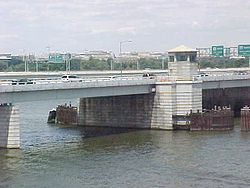
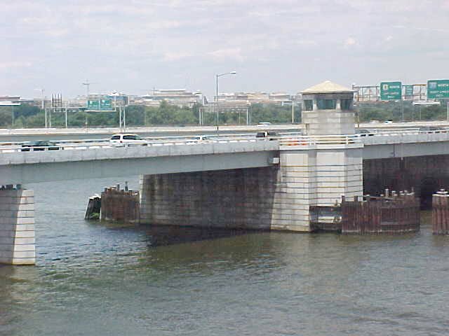
The Arland D. Williams Jr. Memorial Bridge as seen from a Yellow Line train on the Washington Metro (Charles R. Fenwick Bridge).Other name(s) Long Bridge, Charles R. Fenwick Bridge, Arland D. Williams Jr. Memorial Bridge, Rochambeau Bridge, George Mason Memorial Bridge Carries Interstate 395, U.S. Route 1, Yellow Line of the Washington Metro, CSX Transportation rail line Crosses Potomac River Locale Washington, D.C. Opened 1903-1983 The 14th Street Bridge is a complex of five bridges across the Potomac River, connecting Arlington, Virginia, and Washington, D.C. Three of the spans are each four-lane automobile bridges—one northbound, one southbound, and one with two general purpose lanes in each direction—that carry Interstate 395 and U.S. Route 1 traffic.[1] Adjacent to the automobile bridges are two bridges for rail traffic, one for the Yellow Line of the Washington Metro and the other for a CSX Transportation rail line, the only mainline rail crossing of the Potomac River in Virginia. The bridge was the location of the Air Florida Flight 90 airplane crash on January 13, 1982.
At the north end of the bridge, in East Potomac Park, the three roadways merge and split into two two-way bridges over the Washington Channel into downtown Washington, one carrying traffic (including northbound US 1) north onto 14th Street, and the other carrying I-395 (and southbound US 1) traffic onto the Southwest Freeway. The Metro line enters a tunnel in the East Potomac Park, and the main line railroad from the Long Bridge passes over I-395 and runs over the Washington Channel just downstream of the 14th Street approach before turning northeast along the line of Maryland Avenue. The original bridge ran to the junction of 14th Street and Maryland Avenue, with access to either for cars.
Contents
Naming
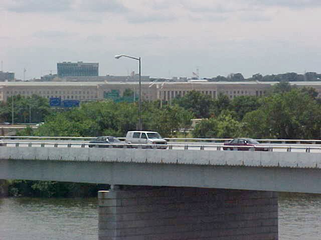
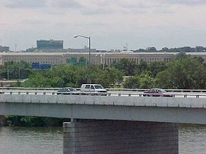 Another view of the Arland D. Williams Jr. Memorial Bridge from the Yellow Line. The Pentagon is visible in the background.
The complex as a whole is named for the street that feeds into it on the D.C. end (carrying northbound US 1 off the bridge), 14th Street. Each of the five separate bridge spans also has its own name. From south to north, the bridges are named as follows:
- The 1903 (rebuilt 1943) Long Bridge carries CSX, Amtrak and Virginia Railway Express rail traffic over the river.
- The 1983 Charles R. Fenwick Bridge—named for Virginia state senator, Charles R. Fenwick, who played a critical role in the creation of Washington Metropolitan Area Transit Authority—carries the Yellow Line of the Washington Metro across the river.
- The northbound span, which opened in 1950, was originally named the Rochambeau Bridge, and was renamed the Arland D. Williams Jr. Memorial Bridge in 1983 for a passenger of Air Florida Flight 90 who died while saving others from the freezing water the previous year.
- At that time, the Rochambeau Bridge name was moved to the previously unnamed center bridge, which opened in 1972 and carries traffic in both directions.
- The southbound span, opened in 1962, is named the George Mason Memorial Bridge. A footpath is located on the upstream side of the bridge for pedestrians and cyclists.
History
The first bridge at the site was the Long Bridge, a wooden toll bridge opened on May 20, 1809, by the Washington Bridge Company. It was the second bridge to cross the Potomac in the District of Columbia, following a 1797 span at a narrower crossing near Little Falls, upstream of Georgetown, at the site of the present Chain Bridge.
British forces leaving the Battle of Bladensburg during the War of 1812 set fire to the north end of the Long Bridge on August 25, 1814, and American troops burned the south end. The bridge was rebuilt by 1816.
The western portion was carried away by an ice freshet on February 23, 1831, and Congress decided to purchase the franchise of the Washington Bridge Company on July 14, 1832. A ferry carried traffic across the river until the bridge was reopened by President Andrew Jackson on October 30, 1835. Another freshet closed the bridge from February 10, 1840 to 1843.
The Washington Branch of the Baltimore and Ohio Rail Road had served Washington from the north since 1835. The Alexandria and Washington Railway, allied with the B&O, was chartered in 1855 to connect the B&O in Washington to other railroads in Alexandria, by then part of Virginia. A Washington ordinance passed July 27, 1855, authorized the A&W to build tracks from the Long Bridge along Maryland Avenue towards the United States Capitol and up First Street to connect with the B&O. The line in Washington was completed to the north end of the Long Bridge in December, but never opened due to local opposition and the inability to get tracks on the bridge. On November 25, 1856, the rest of the A&W was completed, from the south end of the bridge to downtown Alexandria. To reach Washington and the B&O, freight and passengers had to use an omnibus connection over the bridge. The bridge was again washed out by a flood in February 1857, but was reopened by the end of the year, as revenue service on the A&W with connecting service over the bridge began December 21, 1857.
 Union soldiers guard the Long bridge to prevent infiltration by Confederate spies.
With the outbreak of the American Civil War in 1861, the bridge became militarily important. Union troops occupied the bridge May 24, and the Orange and Alexandria Railroad soon became a major center for the United States Military Railroad Construction Corps. Rails were placed on the bridge, and the new connection opened February 9, 1862. Due to weight restrictions, horse power had to be used over the bridge. A new stronger bridge was completed about 100 feet (30 m) downriver July 23, 1864 and opened February 21, 1865. The new bridge carried only railroad traffic, and the old one was kept for other traffic. On November 15, 1865, with the end of the war, the U.S. Military Railroad gave the old bridge to the U.S. Department of the Interior; the new bridge became part of the Washington, Alexandria and Georgetown Railroad, leased by the B&O.
In 1872 the Pennsylvania Railroad obtained control of the bridge and railroad through its Baltimore and Potomac Railroad. On July 2, the Alexandria and Fredericksburg Railway opened, providing the first direct all-rail connection between the north and Richmond, Virginia. The B&O regained its link to the south on March 10, 1874 with a car float between Shepherds Point in Washington and the Washington City, Virginia Midland and Great Southern Railway in Alexandria. (The temporary Shepherd's Landing Bridge would be built there during World War II.)
By June 6, 1896, an interurban streetcar line—the Mount Vernon, Alexandria and Washington Railway—also crossed the bridge. A new railroad-only bridge opened August 25, 1904, about 150 feet (45 m) upriver from the old one, providing two tracks across the river. The railroad bridge contained girders recycled from the PRR's Lower Trenton Bridge across the Delaware River.[2]
In 1901, the Richmond, Fredericksburg and Potomac Railroad, a bridge line owned equally by six companies including the Pennsylvania Railroad and Baltimore and Ohio Railroad (which obtained trackage rights over the PRR to reach the bridge July 1, 1904), obtained trackage rights over the bridge. The RF&P was merged into CSX Transportation in 1991, and in 1998, with the Conrail breakup, CSX acquired the bridge.
 Looking towards Washington in 1932
A new swing-span through-truss bridge called the Highway Bridge, 500 feet (150 m) upriver from that bridge, opened February 12, 1906 to serve non-railroad traffic including streetcars.[3]
On November 9, 1943, a replacement to the railroad bridge (keeping the old 1903 draw span) was opened.
A new northbound highway bridge opened May 9, 1950, halfway between the other two bridges, named the Rochambeau Bridge. The new George Mason Memorial Bridge opened in 1962, replacing the old Highway Bridge (then southbound only). The Highway Bridge was finally removed from the site in 1967, and was moved to the Naval Surface Warfare Center, Dahlgren Division for bombing practice. In 1972, a third bridge opened, just downriver from the southbound (Mason) bridge, carrying two express lanes in each direction. Over time, the lanes were reserved as high-occupancy vehicle lanes. The final bridge, the Charles R. Fenwick Bridge, carrying the Yellow Line, opened April 30, 1983.[4]
The 1950 and 1962 spans incorporated draw spans whose control houses are still visible, complementing the railroad bridge swing bridge downstream and the Arlington Memorial Bridge upstream. Later bridges did not incorporate this feature and the draw mechanisms were abandoned.
The northbound I-395 span was damaged by the Air Florida Flight 90 disaster on January 13, 1982. The Boeing 737-222 had become bogged down by ice during a delay, and was unable to ascend after takeoff, quickly stalling and falling on the bridge before tipping over and slamming into the iced-over Potomac River, killing 73 passengers and crew instantly and four in cars on the bridge. The repaired span was rededicated the Arland D. Williams, Jr. Memorial Bridge. It was named for one of the six survivors of the crash, who sacrificed his life by passing the lifeline on to the other five survivors before permitting himself to be rescued. He died when he succumbed to hypothermia and drowned while rescuers dealt with difficulties rescuing the last of the survivors he passed the line to. The name of Rochambeau Bridge was placed on the previously unnamed express-lane bridge at the same time.
On July 25, 1989, the 14th Street Bridge gained national notoriety when police officers, frustrated by inability to clean up the prostitution problem in D.C.'s 14th Street red-light district, ordered a group of scantily clad women to march from the Thomas Circle area, down 14th Street to Virginia. As the parade passed the Washington Monument about 1:30 in the morning, Washington Post reporter Bill Dedman happened by in a taxi on his way home from the Post newsroom, and began interviewing police officers and the women. He then ran to the Agriculture Department building across the Mall to use a pay phone to ask the Post metro desk to send a photographer. Before a photographer could be sent, Post photographer Stephen Jaffe also happened by on his way home from another assignment. He began taking photos, causing the police officers to flee. The women never crossed the bridge, but because they were on the approach ramp it's clear that the police officers' intent was to make them march into Virginia. After the police left, the women were driven back to Thomas Circle by men in vans, which had been following the parade at a distance, and were back on street corners within half an hour. The next day, after politicians from Virginia complained, others noted that Virginia police had sent homeless people across bridges into D.C.[5][6]
In addition to the Air Florida Flight 90 disaster, another incident occurred at the 14th Street Bridge in 1994. Abubakar Sadiq Ibrahim, an unemployed journalist, who said he wanted to see the daughter who lived with his estranged wife, crashed his Mercedes-Benz into a retaining wall on the span and threatened to explode a bomb. A black canvas bag on his front seat turned out to contain books and clothes.[7]
See also
- Bridge Tender's House, an installation on the bridge's old watchtower
References
- ^ "Virginia Freeway HOV Lanes". Roads To The Future. http://www.roadstothefuture.com/Virginia_Freeway_HOV.html. Retrieved July 15, 2009.
- ^ "Ingenuity Marks Bridge Renewal," Railway Age, vol. 118, No. 3 (Jan. 20, 1945): 187-90.
- ^ William H. Rehnquist. Remarks at the Arlington Historical Society Banquet. April 27, 2001. Retrieved January 25, 2008.
- ^ Washington D.C. Chapter of the National Railway Historical Society. "Washington, D.C. Railroad History". Archived from the original on April 21, 2006. http://web.archive.org/web/20060421081205/http://www.dcnrhs.org/dc_rail_history.htm. Retrieved April 26, 2006.
- ^ Bill Dedman (July 26, 1989). "March Clears Out Prostitution Zone; D.C. Police Criticized After Ordering Women to Walk to Va. Line". Washington Post. http://www.powerreporting.com/files/prostitutes_bridge.txt. Retrieved July 23, 2010.
- ^ Washington, The (2003-07-18). "Washington Times - Police take aim at 'johns' to cut crime". Washtimes.com. http://www.washtimes.com/metro/20030718-112350-1862r.htm. Retrieved 2011-08-19.
- ^ "Jumper on Bridge Causes Gridlock". The Washington Post. November 5, 1998. http://www.washingtonpost.com/wp-srv/local/longterm/wilson/wilson110598.htm. Retrieved August 24, 2006.
External links
- Roads to the Future - 14th Street Bridge Complex (I-395 and US-1)
- Roads to the Future - Virginia Freeway HOV Lanes
- History of the Long Railroad Bridge Crossing Across the Potomac River
- PRR Chronology
Coordinates: 38°52′29″N 77°02′26″W / 38.87468°N 77.04067°W
Bridges of the Potomac River Upstream
Arlington Memorial Bridge14th Street Bridge


 CSX Transportation
Downstream
Woodrow Wilson Bridge

 Categories:
- Railroad bridges in Virginia
- Railroad bridges in Washington, D.C.
- Road bridges in Virginia
- Bridges completed in 1809
- Bridges completed in 1835
- Bridges completed in 1865
- Bridges completed in 1904
- Bridges completed in 1906
- Bridges completed in 1943
- Bridges completed in 1950
- Bridges completed in 1962
- Bridges completed in 1972
- Movable bridges on the Interstate Highway System
- U.S. Route 1
- Interstate 95
- CSX Transportation bridges and tunnels
- Crossings of the Potomac River
- Buildings and structures in Arlington County, Virginia
- Transportation in Arlington County, Virginia
- Road bridges in Washington, D.C.

Wikimedia Foundation. 2010.