- Columbia Island (District of Columbia)
-
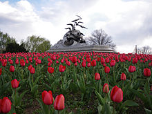
Columbia Island Geography Location Potomac River, Washington, D.C. Coordinates 38°52′56″N 77°03′26″W / 38.8823342°N 77.0571996°WCoordinates: 38°52′56″N 77°03′26″W / 38.8823342°N 77.0571996°W Country Columbia Island is located in the Potomac River in Washington, D.C., and is part of the George Washington Memorial Parkway. Boundary Channel separates the island from the Virginia shoreline to the southwest.[1][2] In 1968, the island was renamed Lady Bird Johnson Park in honor of Johnson and her First Lady's Committee for a More Beautiful Capital planting of hundreds of dogwood trees and thousands of flowers on the island in 1965.[3]
Columbia Island is accessible from downtown Washington via the Arlington Memorial Bridge, from Arlington National Cemetery via Memorial Drive, and from Northern Virginia via the George Washington Memorial Parkway. The island is home to the Lyndon Baines Johnson Memorial Grove on the Potomac, the Navy – Merchant Marine Memorial, and the Columbia Island Marina. The Mount Vernon Trail runs along the side of the island facing the rest of the District, leading to Theodore Roosevelt Island in one direction and Ronald Reagan Washington National Airport on the other. The Pentagon is visible from the western side of the island near the marina at the southern tip.
References
- ^ "Virginia-Maryland Boundary" in Virginia Places by Charles A. Grymes. Retrieved 2010-01-17.
- ^ "Places to Paddle: Potomac River: Boundary Channel along Columbia Island, Pentagon City in Washington D.C." in website of kyakguide.com. Retrieved 2010-01-17.
- ^ National Park Service. "Press release on passing of "Lady Bird" Johnson". http://home.nps.gov/applications/release/Detail.cfm?ID=748. Retrieved July 18, 2007.
Categories:- Islands of Washington, D.C.
- Islands of the Potomac River
- Washington, D.C. geography stubs
Wikimedia Foundation. 2010.

