- Interstate 295 (New York)
-
Interstate 295
Route information Maintained by NYSDOT and Triborough Bridge and Tunnel Authority Length: 9.79 mi[4] (15.76 km) History: Completed in 1963 as I-78;[1][2] renumbered to I-295 on January 1, 1970[3] Major junctions South end: 
 NY 24 / NY 25 in Queens
 Grand Central Parkway at exit 1
 I-495 at exit 4
 Cross Island Parkway at exit 7
 I-695 at exit 10
North end: Bruckner Interchange in The Bronx Highway system Auxiliary route of the Interstate Highway System
Main • Auxiliary • BusinessNumbered highways in New York
Interstate • U.S. • N.Y. (former) • Reference • County←  NY 294
NY 295  →
→Interstate 295 (I-295) is a connector route within New York City. Measuring 9.10 miles (14.6 km) in length, I-295 travels from the Bruckner Interchange, a junction with I-95/I-278/I-678 in The Bronx, across the toll Throgs Neck Bridge to the Grand Central Parkway in Queens. Along the route, 295 meets with I-695 (Throgs Neck Expressway), the Cross Island Parkway, and I-495 (the Long Island Expressway). In Queens, I-295 is also known as the Clearview Expressway. The highway's southern terminus is a traffic signal at Hillside Avenue (NY 25) in the Queens neighborhood of Queens Village, however the original plan was to extend it further south to JFK Airport. The 0.8-mile (1.3 km) JFK Expressway was intended to be part of the Clearview, but was only constructed as far north as Belt Parkway.
Contents
Route description
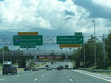
 Clearview Expressway in northeastern Queens
The existing section of the Clearview Expressway that carries the I-295 designation begins at the unfinished interchange with NY 25, and instantly runs beneath a stack interchange with the Grand Central Parkway before immediately entering Cunningham Park. The Clearview leaves Cunningham Park at the interchange with Long Island Expressway, which used to be the eastern terminus of I-495 until the mid-1980s. The northbound off-ramp and southbound on-ramp at NY 25A run under a pedestrian bridge that connects 46th Avenue. Other pedestrian bridges cross over Clearview near 42nd Avenue and at 33rd Avenue. The northbound off-ramp uses 206th Street as a de-facto service road, while 207th Street is used in the same way for the northbound on-ramps. Real service roads run beneath the Port Washington Branch of the Long Island Rail Road to connect NY 25A and 35th Avenue (exit 6A). The northbound partial interchange with Willets Point & Bell Boulevards leads to Cross Island Parkway while a southbound interchange leads to the southbound Cross Island Parkway, all before reaching the Throgs Neck Bridge.
After the Throgs Neck toll booth, I-295 becomes part of the Cross Bronx Expressway. Northbound access to Harding Avenue and Pennyfield Avenue is barley noticeable compared to the Y-interchange with I-695 (Throgs Neck Expressway), which takes motorists to northbound I-95. The only other interchange between there and the terminus is Randall Avenue. Interstate 295 finally ends at its parent route at the Bruckner Interchange, but only includes access to southbound I-95, and Interstate 278.
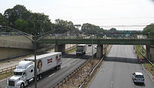
 Southbound I-295 (Cross Bronx Expressway Extension) nearing the Throgs Neck tolls
The Queens section of this roadway is known as "The 77th Infantry Division Expressway", honoring the U.S. Army's 77th Infantry Division of World War I and World War II fame. Raised from draftees from New York City and Long Island, the 77th was also known as the Statue of Liberty Division, due to its shoulder-sleeve insignia.
History
The Cross Bronx Expressway Extension, the Throgs Neck Bridge, and the portion of the Clearview Expressway north of 73rd Avenue in Queens was completed ca. 1961.[1][5] An extension of the Clearview south to Hillside Avenue (now NY 25) was opened to traffic in 1963.[1][2] The Cross Bronx Expressway Extension and the Clearview Expressway were originally designated as part of Interstate 78,[6] which was to continue south from Hillside Avenue to NY 27 in Laurelton and west across Queens, Brooklyn, and Manhattan to the Holland Tunnel.[5] Ultimately, none of I-78 between the Holland Tunnel and Hillside Avenue was built save for a short section near JFK Airport,[7] resulting in the renumbering of all of I-78 north of Hillside Avenue to I-295 on January 1, 1970.[3]
Exit list
County Location Mile[4] Exit Destinations Notes Queens Cunningham Park 0.00 NY 25 (Hillside Avenue)Southbound exit and northbound entrance 0.17 1 Grand Central Parkway0.81 2 Union Turnpike Formerly NY 25C 3 73rd Avenue Southbound exit and northbound entrance Fresh Meadows 1.70 4 I-495 (Long Island Expressway) – Manhattan, Eastern Long IslandSigned as exits 4E (east) and 4W (west) 2.70 5  NY 25A (Northern Boulevard)
Bayside 6A 35th Avenue 6B 26th Avenue Southbound exit and northbound entrance 4.91 7 Willets Point Boulevard Northbound exit and southbound entrance 8 Cross Island Parkway south – Eastern Long IslandSouthbound exit and northbound entrance Throgs Neck Bridge Bronx Locust Point 9 Harding Avenue / Pennyfield Avenue – Fort Schuyler Throgs Neck 7.68 10  I-695 north to I-95 north – New Haven
Northbound exit and southbound entrance 11 Randall Avenue 9.79 Bruckner Interchange Northbound exit and southbound entrance 1.000 mi = 1.609 km; 1.000 km = 0.621 mi References
- ^ a b c Sunoco (1961). New York and Metropolitan New York (Map). Cartography by H.M. Gousha Company (1961–62 ed.).
- ^ a b Esso (1963). New York Happy Motoring Guide (Map). Cartography by General Drafting (1963 ed.).
- ^ a b State of New York Department of Transportation (January 1, 1970) (PDF). Official Description of Touring Routes in New York State. http://www.greaternyroads.info/pdfs/state70.pdf. Retrieved July 12, 2010.
- ^ a b "2008 Traffic Volume Report for New York State" (PDF). New York State Department of Transportation. June 16, 2009. p. 208. https://www.nysdot.gov/divisions/engineering/technical-services/hds-respository/NYSDOT%20TVR%202008%20by%20Route.pdf. Retrieved February 1, 2010.
- ^ a b Gulf Oil Company (1960). New York and New Jersey Tourgide Map (Map). Cartography by Rand McNally and Company.
- ^ Esso (1962). New York with Sight-Seeing Guide (Map). Cartography by General Drafting (1962 ed.).
- ^ State of New York Department of Commerce (1969). New York State Highways (Map). Cartography by Rand McNally and Company.
External links
- Alps' Roads – Interstate 295
- New York Routes – Interstate 295
- I-295 on Kurumi.com
- nycroads.com Clearview Expressway(I-295) info.
- I-295 (Greater New York Roads)
Auxiliary routes of Interstate 95 Florida: 195 • 295 • 395 • 595 • 795 (future) — North Carolina: 295 (future) • 795 — Virginia: 195 • 295 • 395 • 495 • 595 (former) • 895 (proposed) — District of Columbia: 295 • 395 • 495 • 695 (unsigned) — Maryland: 195 • 295 • 395 • 495 • 595 (unsigned) • 695 • 795 • 895 — Delaware: 295 • 495 • 895 (former) — Pennsylvania: 195 (future) • 695 (unbuilt) • 895 (unbuilt) — New Jersey: 195 • 295 • 495 (former) • 695 (unbuilt) • 895 (unbuilt) — New York: 295 • 495 • 695 • 895 — Connecticut - Rhode Island - Massachusetts: 195 • 295 • 395 • 495 • 695 (unbuilt) • 895 (unbuilt) — Maine: 195 • 295 • 395 • 495
Expressways in New York City Manhattan–Bronx Bruckner (I-95/I-278) · Cross Bronx (I-95/I-295) · Major Deegan (I-87) · New England Thruway (I-95) · Sheridan (I-895) · Throgs Neck (I-695) · Trans-Manhattan (I-95)Brooklyn–Queens Brooklyn–Queens/Gowanus (I-278) · Clearview (I-295) · JFK · Long Island (I-495) · Nassau (NY 878) · Prospect (NY 27) · Van Wyck/Whitestone/Hutchinson River (I-678)Staten Island Categories:- Three-digit Interstate Highways
- Interstate Highways in New York
- Expressways in New York City
- Transportation in Queens
- Transportation in the Bronx
- Robert Moses projects
- Interstate 95
- Unfinished buildings and structures in the United States


Wikimedia Foundation. 2010.