- Interstate 395 (Connecticut–Massachusetts)
-
Interstate 395
Route information Maintained by ConnDOT Length: 66.60 mi[1] (107.18 km) Existed: 1968 (as Route 52)
1983 (as I-395) – presentMajor junctions South end:  I-95 (Connecticut Turnpike) in East Lyme, CT
 Route 2 in Norwich, CT
 US 6in Killingly, CT
 US 44 in Putnam, CT
North end: 

 I-90 / I-290 / Route 12 in Auburn, MA
Highway system Auxiliary route of the Interstate Highway System
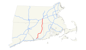
Main • Auxiliary • BusinessInterstate 395 (abbreviated I-395) is a 67-mile-long north–south Interstate Highway that begins at Interstate 95 in East Lyme, Connecticut and ends at Interstate 90 in Auburn, Massachusetts, where it becomes Interstate 290. The original designation for the freeway was Route 52. Route 52 was slated to become an extension of Interstate 290 before it received the I-395 designation in 1983.[2]
From its southern terminus to its intersection at Exit 90 in Plainfield, Connecticut with State Road 695, I-395 is also part of the Connecticut Turnpike.
Contents
Route description
From East Lyme to Plainfield, Connecticut, I-395 is part of the Connecticut Turnpike (the Gov. John Davis Lodge Turnpike). From Plainfield to Thompson, Connecticut, I-395 is named The American Ex-Prisoner of War Memorial Highway.
Service plazas
In Connecticut, there are three Service Plazas that provide 24-hour gas stations and convenience stores. They do not have restaurants but do have phones and rest rooms.
- Montville — MP 8 - Southbound only between exits 79A and 79.
- Plainfield — MP 35 - Northbound and Southbound between exits 89 and 90.
A State Police station is located on the northbound side of the highway in Montville in what used to be another Service Plaza.
History
Exit list
Location # Mile Destinations Notes E. Lyme 76N 88.48 I-95 north – New London, Groton76S 89.24 I-95 south – New HavenWaterford 77 90.61  Route 85 – Waterford, Colchester, Chesterfield
Montville 78 93.82  Route 32 (via SR 693) – New London
Southbound exit and northbound entrance 79 94.78  Route 163 – Uncasville, Montville
79A 97.98  Route 2A east – Ledyard, Preston
South end of Route 2A overlap Norwich 80 99.56  Route 82 – Salem, Downtown Norwich
81 102.19 Route 2 / Route 32 / Route 2A west – Hartford, Colchester, NorwichNorth end of Route 2A overlap; signed as exits 81E (east/south) and 81W (west/north) 82 102.71 West Town Street (SR 642) – Yantic, Norwichtown 83 106.65  Route 97 – Taftville, Occum
Lisbon 83A 108.01  Route 169 – Lisbon
Northbound exit and southbound entrance 84 109.64  Route 12 – Jewett City, Griswold, Lisbon
Signed as exits 84S (south) and 84N (north) southbound Griswold 85 110.43 
 Route 138 / Route 164 – Preston City, Pachaug, Jewett City, Griswold
86 112.74  Route 201 – Hopeville, Jewett City
Plainfield 87 116.71 Lathrop Road (SR 647) – Plainfield, Hopeville 88 118.13  Route 14A – Plainfield, Oneco
89 120.49  Route 14 – Central Village, Sterling, Moosup, Wauregan
Killingly 91 121.34 US 6 – Danielson, East Brooklyn, South KillinglySigned as exit 91E (east) and 91W (west). 92 124.89 Lhomme St., Westcott Rd. – South Killingly, Danielson SR 607 93 127.28  Route 101 – Dayville, East Killingly, Rogers, Pomfret
94 131.45 Lake Rd. – Attawaugen, Ballouville Putnam 95 137.26 Kennedy Drive 96 142.19 To Route 12 – Putnam, Putnam Heights97 144.98 US 44 – Woodstock, Putnam, East PutnamThompson 98 149.08 Route 12 – Grosvenor DalePartial interchange: NB exit/SB entrance only 99 150.23  Route 200 – North Grosvenor Dale
100 153.60 Wilsonville Rd. – East Thompson, Wilsonville Connecticut–Massachusetts State Line (MP 54.7/0.0) Webster 1 1.3  Route 193 – Webster
2 3.7  Route 16 – Webster, Douglas
3 4.0 Cudworth Road - North Webster, South Oxford Oxford 4 6.7 Sutton Avenue - Oxford, Sutton Cloverleaf interchange 5 9.0 Depot Road - North Oxford Auburn 6 11.5 
 US 20 to Route 146 – Shrewsbury, Auburn, Sturbridge
7 11.9 Route 12 / I-90Southbound exit only  ends at the I-90 / I-290 interchange (MP 11.9)
Route and exit numbering continues on I-290References
- ^ "Route Log and Finder List - Interstate System: Table 2". FHWA. http://www.fhwa.dot.gov/reports/routefinder/table2.cfm. Retrieved 2007-10-03.
- ^ "State Ordered To Lift Ban on Tandem Trucks." Hartford Courant, June 14, 1983. The article lists "I-290 (formerly Route 52)" as one of the highways the lifting of the ban applies to.
External links
Auxiliary routes of Interstate 95 Florida: 195 • 295 • 395 • 595 • 795 (future) — North Carolina: 295 (future) • 795 — Virginia: 195 • 295 • 395 • 495 • 595 (former) • 895 (proposed) — District of Columbia: 295 • 395 • 495 • 695 (unsigned) — Maryland: 195 • 295 • 395 • 495 • 595 (unsigned) • 695 • 795 • 895 — Delaware: 295 • 495 • 895 (former) — Pennsylvania: 195 (future) • 695 (unbuilt) • 895 (unbuilt) — New Jersey: 195 • 295 • 495 (former) • 695 (unbuilt) • 895 (unbuilt) — New York: 295 • 495 • 695 • 895 — Connecticut - Rhode Island - Massachusetts: 195 • 295 • 395 • 495 • 695 (unbuilt) • 895 (unbuilt) — Maine: 195 • 295 • 395 • 495
Interstate Highways in Massachusetts Current Browse numbered routes ←  I-384
I-384CT I-684  →
→←  I-391
I-391MA I-495  →Categories:
- Three-digit Interstate Highways
- Interstate Highways in Massachusetts
- Interstate Highways in Connecticut
- Interstate 95


Wikimedia Foundation. 2010.