- Connecticut Route 2
-
"CT 2" redirects here. For the congressional district, see Connecticut's 2nd congressional district. For other uses, see CT2 (disambiguation).For the Route 2 that existed in the 1920s, see U.S. Route 5 in Connecticut.
Route 2

Route information Maintained by ConnDOT Length: 58.03 mi (93.39 km) Existed: 1932 – present Major junctions West end: Columbus Boulevard in Hartford 
 I-84 / US 6 in East Hartford
 I-395 in Norwich
 I-95 in N. Stonington
East end:  US 1 in Stonington
Highway system Routes in Connecticut
Special Service Roads • State Roads← [[File:US Expression error: Unrecognised word "a".svg|x20px|link=|alt=]] US 1A Route 2A  →
→Route 2 is a state highway in Connecticut and is 58.03 miles (93.39 km) in length. It is a primary state route, with a freeway section connecting Hartford to Norwich and a non-freeway section extending to Stonington.
Contents
Route description
Route 2 begins as a continuation of State Street (just east of Columbus Blvd) near Interstate 91 in downtown Hartford. It starts out heading east toward East Hartford. Route 2 then crosses the Connecticut River on the Founders Bridge and has a partial interchange with I-91 at the crossing. Immediately after crossing into East Hartford, there is a complex interchange with Interstate 84. Immediately after this interchange, Route 2 heads southeast in the direction of Glastonbury. There is a partial interchange with Route 15 about 0.75 miles (1.21 km) further. After East Hartford, Route 2 enters Glastonbury. At the East Hartford-Glastonbury town line, there is a full trumpet interchange with Route 3. About 1 mile (1.6 km) after this interchange, there is a partial interchange with Route 17. From Glastonbury, Route 2 passes into Marlborough. It continues into Colchester. In Colchester, Route 2 has a partial interchange with Route 11. After this interchange, Route 2 curves and heads east toward Norwich. Once Route 2 leaves Colchester, it passes through the towns of Lebanon and Bozrah. After Bozrah, Route 2 enters Norwich. Just after entering Norwich, Route 32 joins Route 2. Then, about 1.5 miles (2.4 km) down Route 2, there is a partial cloverleaf interchange with Interstate 395. About 1.75 miles (2.82 km) further east from the I-395 interchange, the freeway section of Route 2 ends at a four-way at-grade intersection with Town Street, Harland Road (Route 169), and Washington Street (Route 32/Route 2). Route 32 then separates in downtown Norwich after overlapping with Route 2 for 3.9 miles (6.3 km), following the west bank of the Thames River. Route 2 continues southeast from Norwich into Preston, and then into Ledyard. Just after entering Ledyard, Route 2 passes by the Mashantucket Pequot Reservation and then the Foxwoods Resort Casino. After passing through Ledyard, Route 2 continues into North Stonington. There is a roundabout with Route 184 and a partial interchange with Interstate 95 here. After leaving North Stonington, Route 2 heads into Stonington. Here, Route 2 is reduced to a minor arterial road. It has an interchange with Route 78 and terminates about 1.5 miles (2.4 km) later at the junction with US 1 just west of the Rhode Island state line.[1]
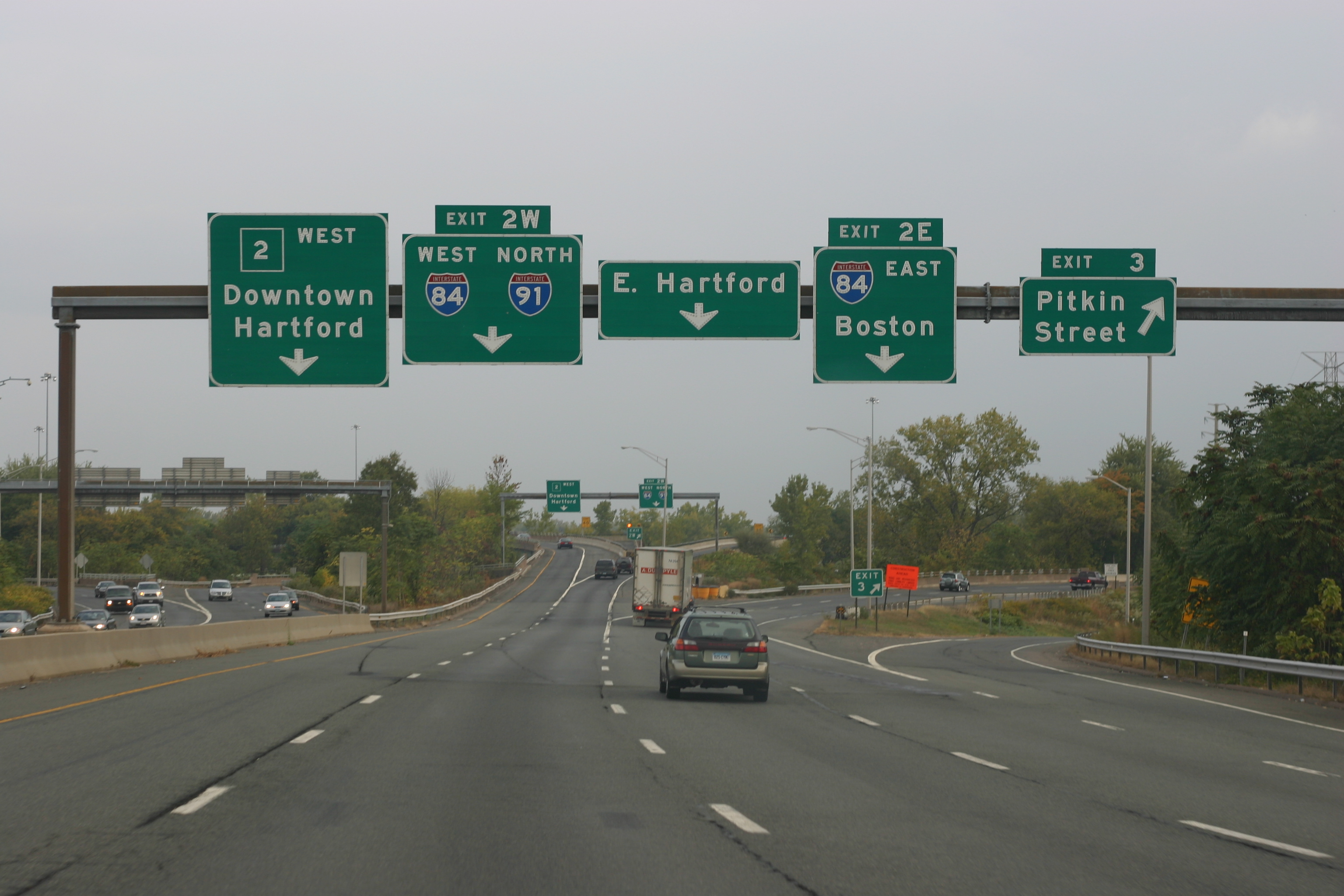
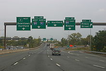 Route 2 westbound in Hartford, just before exits 2E, 2W and 3.
Several Connecticut freeways terminate at Route 2. Route 3 ends at Route 2 near the East Hartford-Glastonbury town line, Route 17 ends at Route 2 in Glastonbury, and Route 11 ends at Route 2 in Colchester. Route 78 also ends at Route 2, in Stonington. It is unusual that Route 78 intersects Route 2 where it is not a freeway.
Special designations
The entire length of Route 2 is also known as the Veterans of Foreign Wars Memorial Highway.[1]
History
Two early toll roads, the Hartford and New London Turnpike and the Colchester and Norwich Turnpike, followed the alignment of current Route 2 in the 1800s. In 1922, The New England Interstate system incorporated the future Route 2 alignment as Route 17. Upon the discontinuation of the New England routes in the 1932 state highway renumbering, the eastern half of old New England Route 17 was renumbered to Route 2. The western half of old New England Route 17 eventually formed part of U.S. Route 44.[2][3]
Freeway construction along the Route 2 alignment started in the 1950s and continued through the 1960s and early 1970s. The oldest freeway segment, between exits 5A and 7, opened in 1952; the latest segment, between exits 20 and 22, opened in 1971. The state still maintains some segments of the older, non-freeway alignment, but does not sign these segments as state routes. The state remanded the remaining non-freeway segments to town jurisdiction.[3]
Junction list
Location Mile Exit Destinations Notes Hartford 0.0 Columbus Boulevard Western terminus of Route 2; at-grade intersection; road continues as State Street 0.1  I-91 south – Wethersfield
Eastbound exit and westbound entrance East Hartford 0.3 1 Pitkin Street, East River Drive Eastbound exit and westbound entrance; milepost at off-ramp 0.5 2 I-84 / US 6 east – East Hartford, VernonEastbound exit and westbound entrance; milepost at off-ramp 0.9 2N, 2E, 2W 2N: East Hartford (SR 500)
2E: I-84 / US 6 east – East Hartford, Vernon
2W: I-84 / US 6 west to I-91 north – West Hartford, Waterbury, Windsor LocksWestbound exits and eastbound entrances; milepost at off-ramp 1.0 3 Pitkin Street Westbound exit only; milepost at off-ramp 1.5 4 East River Drive (SR 502) 
 To US 5 to Route 15 south / I-91
Westbound exit and eastbound entrance; milepost at Route 15 junction 2.0 5 Willow Street (SR 516) Eastbound exit and westbound entrance 2.8–
2.95A High Street
Main StreetSR 517; signed for High Street eastbound and Main Street westbound 3.3 5B Sutton Avenue Eastbound exit and westbound entrance 3.7 5C Maple Street Partial diamond interchange, eastbound exit only 4.0 5D  Route 3 south – Glastonbury, Wethersfield
Full trumpet interchange Glastonbury 4.7 6 Griswold Street Eastbound exit and westbound entrance; no access to this exit from Route 3 entrance ramp 5.1 7  Route 17 south – South Glastonbury
Eastbound exit and westbound entrance 5.6 8  Route 94 (Hebron Avenue)
Westbound entrance and eastbound entrance 7.1 9 Neipsic Road Eastbound exit and westbound entrance 9.9 10 
 Route 83 north / Route 160 west – East Glastonbury, Manchester, South Glastonbury
Full diamond interchange ~11.0 11 Thompson Street, Wassuc Road Westbound exit and eastbound entrance Marlborough 13.6 12 West Road, Marlborough Business Route Eastbound exit and westbound entrance 15.4 13  Route 66 – Marlborough, Willimantic, Hebron, East Hampton
Full diamond interchange 17.9 15 South Main Street – Marlborough Westbound exit and eastbound entrance Colchester 20.4 16  Route 149 – Westchester, Moodus
22.4 17 Colchester Business Route Eastbound exit and westbound entrance 23.7 18  Route 16 – Colchester, Westchester
24.4 19  Route 11 south – New London
Eastbound exit and westbound entrance 25.0 20 
 Route 354 (Parum Road) to Route 85 / Route 11
Westbound exit and eastbound entrance ~26.1 21 Chestnut Hill Road
Colchester Business RouteSR 616; signed as Chest Hill Road eastbound and the Colchester Business Route westbound Lebanon 30.9 22 Standish Road, Lebanon Full diamond interchange Bozrah 33.3 23  Route 163 – Bozrah, Montville, Fitchville
34.5 24 Fitchville Westbound exit and eastbound entrance; SR 608 Norwich 35.9 25
27 Route 32 north – Willimantic, Franklin
West Town Street – YanticWestern end of Route 32concurrency; SR 642; signed as exit 25 for Route 32 eastbound and exit 27 for West Town Street westbound 36.3 27 Otrobando Avenue / West Town Street, Yantic Westbound exit and eastbound entrance; eastbound exit 27 is the same interchange as exit 25; milepost at off-ramp 37.0 28 I-395 / Route 2A south – East Lyme, Mohegan, Plainfield, DanielsonPartial cloverleaf interchange; signed as exits 28S (I-395/Route 2A south) and 28N (I-395 north) 37.7 29 New London Turnpike, Norwichtown Full diamond interchange 38.2  Route 169 (Harland Road)
End of freeway; four way at-grade intersection 39.6  Route 32 / Route 82 south – Mohegan, Salem
East end of Route 32 concurrency 40.2  Route 12
40.5  Route 165
Preston 43.0  Route 2A west / Route 117 south – Ledyard, Happyland
45.7  Route 164
Ledyard 47.3 Entrance to Foxwoods Resort Casino North Stonington 48.0  Route 214
51.1  Route 201
54.4  Route 184
55.3 I-95 – New London, Providence, RIStonington 56.0  Route 49
56.6  Route 78 east
58.0 US 1 – Stonington, Westerly, RI1.000 mi = 1.609 km; 1.000 km = 0.621 mi References
- ^ a b Connecticut State Highway Log (2006)
- ^ F.J. Wood, The Turnpikes of New England, (Marshall Jones, 1919)
- ^ a b nycroads.com - CT Route 2
Coordinates: 41°36′19″N 72°25′19″W / 41.605175°N 72.421875°W
Categories:- State highways in Connecticut
- Transportation in Hartford County, Connecticut
- Transportation in New London County, Connecticut


Wikimedia Foundation. 2010.