- U.S. Route 5 in Connecticut
-
This article is about the section of U.S. Route 5 in Connecticut. For the entire length of the highway, see U.S. Route 5.
U.S. Route 5
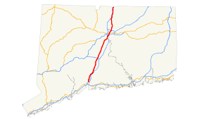
Route information Maintained by ConnDOT Length: 54.59 mi[1] (87.85 km) Existed: 1926 (1922 as Route 2) – present Major junctions South end:  I-91 in New Haven
 I-691 in Meriden
 Route 9 in Berlin
I-91 in HartfordNorth end:  US 5 in Longmeadow, MA
Highway system United States Numbered Highways
List • Bannered • Divided • ReplacedRoutes in Connecticut
Special Service Roads • State Roads←  Route 4
US 6  →
→U.S. Route 5 (US 5), a north–south U.S. Highway that is generally paralleled by Interstate 91, begins at the city of New Haven in Connecticut and heads north through western Massachusetts and eastern Vermont to the international border with Canada. Within Connecticut, US 5 proceeds north from New Haven and passes through Meriden and Hartford towards Springfield, Massachusetts.
US 5 begins at Exit 5 of I-91 northeast of downtown New Haven, heading north through the suburbs of New Haven. It crosses the Quinnipiac River in North Haven, shifting eastward to a different road. US 5 continues north through the town of Wallingford before entering the city of Meriden. North of Meriden, it becomes a four-lane divided highway known as the Berlin Turnpike, where a long overlap with Route 15 also begins. US 5 continues through the southern suburbs of Hartford along the Berlin Turnpike, shifting just south of the city line to the Wilbur Cross Highway, a limited access highway. The Wilbur Cross Highway bypasses downtown Hartford and crosses the Connecticut River on the Charter Oak Bridge into East Hartford. From here, US 5 exits the Wilbur Cross Highway and runs along a four-lane, divided surface road to South Windsor before returning to a two-lane road the rest of the way to the Massachusetts state line in Enfield.
US 5 roughly follows the route used by the Upper Boston Post Road, an early colonial highway for transporting mail between New York City and Boston. The route was first improved in 1798 as the Hartford and New Haven Turnpike, which ran in a nearly straight line between the court houses of New Haven and Hartford. In 1922, the Upper Boston Post Road corridor was designated as Route 2 of the New England road marking system, crossing to the east of the Connecticut River in Hartford before continuing north to the Massachusetts state line. In 1926, Route 2 was redesignated as U.S. Route 5. Several realignments have been made in the cities of New Haven and Hartford with the opening of several expressways in these areas. Because it is closely paralleled by Interstate 91 between New Haven and Hartford, US 5 serves mainly as a secondary route today.
Contents
Route description
New Haven area
US 5 begins on State Street at exit 5 of Interstate 91 in New Haven. State Street continues southwest into downtown as a local, unnumbered street. US 5 starts out as an undivided four-lane road becoming two lanes just before crossing into Hamden. State Street continues north through Hamden and the industrial section of North Haven, closely paralleling the Amtrak railroad tracks on the west side of the Quinnipiac River. It has an interchange with Route 40 in this area. US 5 then turns right at the intersection with Bishop Street in North Haven and crosses the Quinnipiac River, the railroad tracks, and I-91 (at Exit 11) overlapped with Route 22 on a four-lane wide road.[1][2]
The bridge ends at a four-way intersection where US 5 turns left on Washington Avenue, Route 22 continues straight on Clintonville Road, and Route 103 begins on the right along Washington Avenue. The four-lane Washington Avenue runs through the commercial areas of North Haven still paralleling the railroad tracks, crosses under I-91 (at Exit 12) and continues into Wallingford as South Colony Street. At the town line is the Wharton Brook State Park just north of which is a short expressway connector (Wharton Brook Connector) to I-91 (at Exit 13). South Colony Street narrows to two lanes within the Wallingford town center.[1][2]
After crossing Center Street (Route 150) near the Wallingford train station, the road becomes North Colony Street and heads out of the town center. The road crosses Route 68 at a grade-separated junction about two miles (three km) later, followed by a series of junctions about half a mile (0.8 km) apart each: an interchange with the Wilbur Cross Parkway (at Exit 66), a split to the left where Route 71 begins and a merge from the left where Route 150 ends.[1][2]
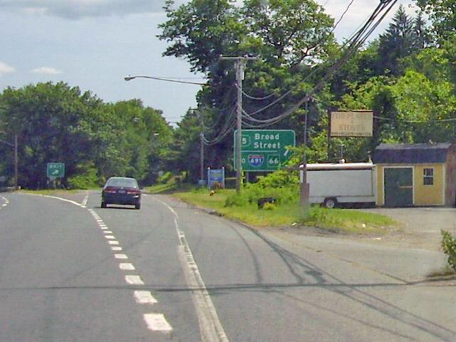
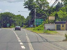 South end of the overlap between Route 15 and US 5. US 5 is signed as an unnumbered exit indicating "To I-691, Route 66
At the merge with Route 150 just before the town line, US 5 then follows South Broad Street (the alignment of the old Hartford and New Haven Turnpike) into the city of Meriden. South Broad Street becomes Broad Street after the intersection with Hall Avenue as it passes by the eastern part of the city, avoiding the downtown area. Past Olive Street, the road becomes divided with a wide grassy median. At the north end of the divided section, it has an intersection with East Main Street, the main east–west business route through the city. About 0.7 miles (1.1 km) north of East Main Street, US 5 has an interchange with I-691 (at Exit 8). At the intersection with Brittania Street, the road becomes North Broad Street, which climbs up on a slope as it meets with the north end of the Wilbur Cross Parkway. The northbound roadway overpasses the Parkway and then merges onto it from the right. This is the beginning of a 15-mile (24 km) overlap with Route 15. Southbound at the beginning of the Parkway, US 5 is signed as an exit (with no number) from the main roadway. North Broad Street continues north from the merge as a divided 4-lane arterial road for another 1.1 miles (1.8 km) up to the Berlin town line, where the road becomes the Berlin Turnpike.[1][2]
Hartford area
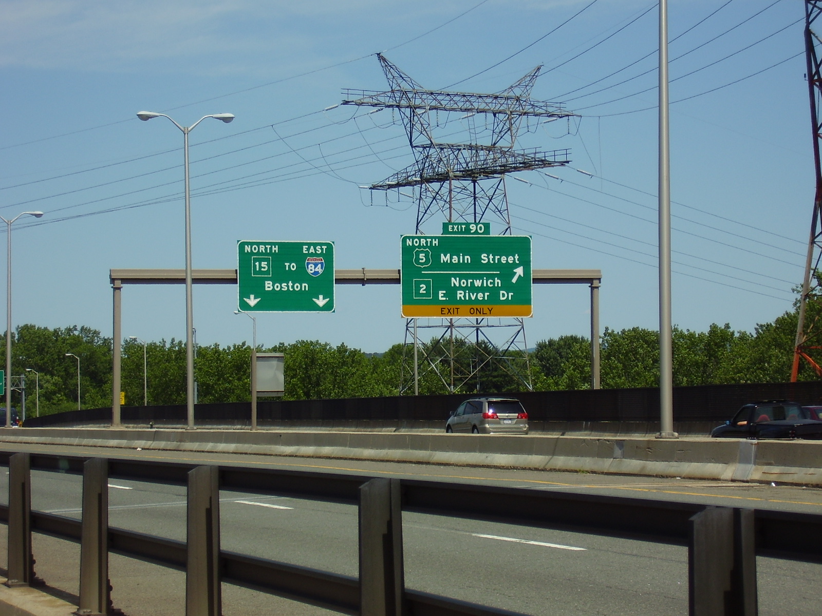
Main articles: Berlin Turnpike and Wilbur Cross Highway North end of the Route 15-US 5 overlap on the Wilbur Cross Highway
US 5 and Route 15 run for 10 miles (16 km) along the Berlin Turnpike within the towns of Berlin, Newington, and Wethersfield. The Berlin Turnpike is mostly a four-lane divided arterial road with some six-lane sections and is the alignment of the old Hartford and New Haven Turnpike. In Berlin, it has an interchange with the Route 9 expressway. In Wethersfield, Routes 5 and 15 leave the Berlin Turnpike to travel along the Wilbur Cross Highway, an expressway bypass along the south of downtown Hartford. The Wilbur Cross Highway runs through Wethersfield and Hartford, then crosses the Connecticut River into East Hartford on the Charter Oak Bridge. Just prior to the river crossing in Hartford, the Wilbur Cross Highway runs parallel to and interconnects with I-91 near the vicinity of Brainard Airport. Just after the crossing, US 5 exits from the Wilbur Cross Highway on Exit 90, ending the long overlap with Route 15. US 5 continues north to East Hartford center along Main Street.[1][3]
From East Hartford northward to the Massachusetts state line, US 5 runs along the east bank of the Connecticut River. Main Street in East Hartford is mostly a 4-lane divided highway. It crosses under I-84 about 0.5 miles (0.80 km) north of the split with Route 15 with access to the westbound direction only. Main Street continues through the town center, intersecting (and briefly overlapping) U.S. Route 44. North of the town center, US 5 leaves Main Street to go on Ellington Road (via a short segment of King Street) until the South Windsor town line, where the road becomes known as John Fitch Boulevard (still a four-lane divided arterial road). About half a mile (0.8 km) further north, US 5 has an interchange with I-291 (at Exit 4) that also includes access to Route 30, the main road to the South Windsor town center. John Fitch Boulevard continues through the rest of South Windsor, passing through the village of East Windsor Hill near the East Windsor town line.[1][4]
After crossing into the town of East Windsor, the roadway becomes two lanes wide with auxiliary left turn lanes and is known as South Main Street. It intersects with Route 191 (Phelps Street), which leads to the East Windsor town center. About half a mile (0.8 km) north of this junction, US 5 leaves Main Street to go on Prospect Hill Road, bypassing the Warehouse Point area. There is also a partial interchange with I-91 in this area (at Exit 44). Just south of the Enfield town line, US 5 intersects with Route 140, which crosses the Connecticut River into the town of Windsor Locks and Bradley International Airport.[1][4]
In Enfield, the road becomes known as King Street, crossing over I-91 with a full interchange (Exit 46). As it approaches the town center, the road becomes known as Enfield Street. It has a grade-separated intersection with Route 190 in this area. Just before going across the state line, US 5 crosses over I-91 again (at Exit 49) and becomes Longmeadow Street as it enters the town of Longmeadow, Massachusetts.[1][4]
History
The Upper Boston Post Road was established in 1673 between New York and Boston via New Haven, Hartford, Springfield, and Worcester. From New Haven to Hartford, it ran at various times via Middletown (now roughly Route 17 and Route 99) and via Meriden (now very roughly US 5). North of Hartford, the road remained on the west side of the Connecticut River, following the general path of present Route 159.[5]
Along this route between New Haven and Hartford, the Hartford and New Haven Turnpike was chartered in 1798 and opened in 1799, beginning at Grove Street in New Haven and leaving on Whitney Avenue, passing via Meriden and Berlin, and entering Hartford on Maple Avenue. This was one of the first turnpikes to be built on a straight line rather than along existing roads.[6]
In the 1910s, Connecticut and Massachusetts adopted a system of marking major roads by colors. The route from New Haven to Springfield, crossing the Connecticut River at Hartford, was marked with blue bands, signifying a major north–south route. This route crossed the Quinnipiac River in New Haven, heading north along an old road (now Route 103 and US 5) to Tracy, crossing the turnpike and running through downtown Meriden on Old Colony Road, Cook Avenue, and Colony Street. It then used the turnpike alignment from Lamentation State Park into Hartford. From East Hartford north to Springfield, another older road was used.[7]
 New England Route 2 shield
When the New England road marking system was adopted in 1922, Route 2 was assigned to a route from New Haven north via Hartford and Springfield towards Sherbrooke, Quebec. This route followed the older blue-banded route from New Haven north to Hartford. At Hartford, Route 2 crossed the Connecticut River on the Bulkeley Bridge and ran north from East Hartford to Springfield on the east side of the river.[8][9]
U.S. Route 5 was designated in 1926 along the Route 2 alignment.[10] Between 1926 and 1932, U.S. Route 5 and Route 2 were co-signed throughout the length of the route.[11] In the 1932 state highway renumbering, the Route 2 designation was removed, leaving only the US 5 designation. Only a small number of changes have been made since then, the most prominent being in the cities of New Haven and Hartford.
US 5 initially used Temple Street, Whitney Avenue, Edwards Street and upper State Street in New Haven, beginning at U.S. Route 1 (Chapel Street).[12] By the 1940s, it had been moved onto a bypass of the downtown area, consisting of Edwards Street, Hillside Place, Munson Street, Henry Street, Sherman Avenue, Winthrop Avenue, and Davenport Avenue, ending at US 1 west of downtown. At the time, it still crossed the river on Middletown Avenue; the route leaving to the north on State Street was signed as an alternate route.[13] The main and alternate routes were swapped by the mid-1950s, and US 5 was sent down East Street to US 1. (The alternate is now Route 103.) The old bypass became extensions of Route 80 and Route 10,[14] but is now unnumbered. The final changes truncated US 5 to I-91 when I-91 opened in 1966 in New Haven,[15] and relocated US 5 to the new Route 22 Connector across I-91 in North Haven in 1973, leaving the old route on Broadway as unsigned State Road 729.[16]
In Hartford, the original alignment of US 5 entered the city on Maple Avenue and made its way to the Bulkeley Bridge via Main Street, Central Row, and Columbus Boulevard.[12] The route was shifted slightly eastward to Wyllys Street and Columbus Boulevard by 1941.[17] The opening of the Charter Oak Bridge and Hartford Bypass on September 5, 1942[18] led to US 5 bypassing downtown Hartford on its current alignment; U.S. Route 5A, an alternate route on the west side of the Connecticut River to Springfield, was extended south along Main Street to the beginning of the bypass.[19]
In the early 1940s, several sections of US 5 in the Hartford area were upgraded to four-lane boulevards. The Berlin Turnpike segment was reconstructed as a divided four-lane highway, with several segments also straightened out. In East Hartford and South Windsor, a new four-lane divided highway, John Fitch Boulevard, was also constructed. Both of these roadways opened in 1942.[20] In 1948, Route 15 was designated on the Berlin Turnpike and Hartford Bypass segments of US 5 in order to connect the Merritt Parkway and Wilbur Cross Parkway to the Wilbur Cross Highway, providing a continuous high-speed route between New York and Massachusetts.[21]
Special designations
Many sections of various state highways in Connecticut have commemorative designations for various veterans organizations or groups, as well as military servicemen and Connecticut State Troopers killed in the line of duty. In the case of U.S. Route 5, most of its non-expressway alignment except for the Berlin Turnpike has been given a commemorative designation by the Connecticut General Assembly over the years. The following segments of U.S. Route 5 have such designations:
- The portion from the Hamden-North Haven line to Devine Street (SR 720) in North Haven is also known as the "Korean War Veterans Chapter 204 Memorial Highway".[22]
- The portion from Devine Street (SR 720) to Bishop Street in North Haven is also known as the "VFW Post 10128 Memorial Highway".[22]
- The Route 5/22 connector between State Street and Washington Avenue in North Haven is also known as the "Officer Timothy W. Laffin Memorial Highway". Timothy Laffin was a North Haven Police officer who lost his life in a motor vehicle accident while pursuing a wanted suspect.[23]
- South Colony Street in Wallingford, running from the North Haven-Wallingford line to Route 150 in Wallingford center, is also known as the "American Legion Shaw-Sinon Post 73 Memorial Highway".[24]
- South Broad Street from the northern Route 150 junction in Wallingford to the Meriden town line is also known as the "VFW Connecticut Ladies Auxiliary Highway".[25]
- The portion from the I-84 junction in East Hartford to the East Windsor-Enfield line is also known as the "Purple Heart Highway".[26]
Junction list
Town Mile[1] Exit Intersection Notes New Haven 0.0 I-91Exit 5 of I-91 0.4 Ferry Street Old US 5A, Route 17, and Route 80 N. Haven 4.6 Dixwell Avenue (SR 717) 4.7  Route 40
Access via SR 717 and SR 720 4.8 Devine Street (SR 720) 5.7 Broadway (SR 729) Old US 5 and Route 22 5.8  Route 22 west (Bishop Street)
Route 22 overlap begins 6.2 I-91 southExit 11 of I-91 6.5 Route 22 east (Clintonville Rd.)
 Route 103 south (Washington Ave.)
Route 22 overlap ends 7.2 I-91Exit 12 of I-91 Wallingford 9.4 Wharton Brook Connector (SR 702) Connects to exit 13 of I-91 11.4  Route 150 (Center St. Hall St. Quinnipiac St.)
13.6  Route 68 (Church St.)
14.0  Route 15 (Wilbur Cross Parkway)
Exit 66 of Route 15 14.4  Route 71 north (Old Colony Rd.)
Old US 5A 14.9 Route 150 south (Broad St.)Meriden 17.1 Main Street Old US 6A 17.8 I-691Exit 8 of I-691 19.3 Route 15 south (Wilbur Cross Parkway)Route 15 overlap begins Berlin 20.4 Colony Road Old US 5A 22.6 Worthington Ridge Road Old US 5A 24.0 Route 9Exit 21 of Route 9 24.0  Route 372 (Mill St.)
24.4 Worthington Ridge Road (SR 572) Old US 5A 25.2  Route 160 (Deming Road)
Newington 26.7  Route 173 north (Richard St.) – West Hartford
27.3  Route 176 north (Main St.)
28.7  Route 287 west (Robbins Ave.)
Route 287 overlap begins 28.8 Route 287 east (Prospect St.)Route 287 overlap ends Wethersfield 29.4  Route 175 (Wells Rd.) – Wethersfield, Newington
Russell Road (SSR 424)30.4  Route 314 east (Berlin Turnpike)
A short piece of Berlin Turnpike southbound is SR 919
Old US 5A32.2 85  Route 99 south (Silas Deane Highway) – Rocky Hill, Wethersfield
Hartford 32.8 86 I-91 south – WethersfieldExit 28 of I-91 33.0 87  Brainard Road, Airport Road (SR 530) – Brainard Airport
Old US 6 33.8 89  I-91 north to I-84 – Hartford, Windsor Locks
Exit 29 of I-91
Old US 5A and Route 934.3 Charter Oak Bridge over the Connecticut River East Hartford 34.6  Route 2 / E. River Dr. – Glastonbury, Hartford
34.9 Main Street (SR 517) Old Route 2 and Route 17 35.0 Route 15 north (Wilbur Cross Highway)Route 15 overlap ends 35.1 East River Drive Extension (SR 502)
Silver Lane (SR 502)Old US 6 35.5 I-84 / US 635.8  US 44 west (Connecticut Blvd.)
US 44 overlap begins 36.2 US 44 east (Burnside Ave.)US 44 overlap ends 37.2 Main Street Old US 5A South Windsor 38.6  Route 30 east (Ellington Rd.)
38.8  I-291
I-291Exit 4 of I-291 42.5  Route 194 east (Sullivan Ave.)
42.6 Main Street Old US 5A East Windsor 45.0  Route 191 east (Phelps Rd.)
46.5 Main Street (SR 510) 46.7 I-91Exit 44 of I-91 47.8  Route 140 (Bridge St.; North Rd.)
Enfield 48.6 Depot Hill Road (SR 510) Old Route 20 49.3 I-91Exit 46 of I-91 52.0 Frew Terrace (SR 515) 52.0  Route 190 (Hazard Ave.)
Access via SR 514 and SR 515 52.1 Franklin Street (SR 514) 52.6  Route 220 east (Elm St.)
Old Route 190 54.3 I-91Exit 49 of I-91 54.6 Massachusetts state line References
- ^ a b c d e f g h i j Connecticut Department of Transportation, Highway LogPDF (1.80 MiB) as of December 31, 2006
- ^ a b c d Google, Inc. Google Maps – overview map of US 5 south of Meriden (Map). Cartography by Google, Inc. http://maps.google.com/maps?f=d&hl=en&geocode=12352311947272237825,41.316350,-72.904320%3B7080410570806184458,41.552540,-72.779880%3B17859395884624550329,41.562361,-72.775207&saddr=State+St%2FUS-5+%4041.316350,+-72.904320&daddr=N+Broad+St%2FUS-5+N+%4041.562361,+-72.775207&mra=mr&mrcr=0&dirflg=h&sll=41.561197,-72.774886&sspn=0.060626,0.116043&ie=UTF8&ll=41.447873,-72.780304&spn=0.485858,0.928345&z=10. Retrieved 2008-04-09.
- ^ Google, Inc. Google Maps – overview map of US 5 from Meriden to Hartford (Map). Cartography by Google, Inc. http://maps.google.com/maps?f=d&hl=en&geocode=2656088543658043920,41.562660,-72.775200%3B1106088421824386168,41.757168,-72.643350&saddr=Berlin+Turnpike%2FCT-15+N%2FUS-5+N+%4041.562660,+-72.775200&daddr=41.71361,-72.694302+to:Unknown+road+%4041.757168,+-72.643350&mra=dpe&mrcr=0&mrsp=1&sz=14&via=1&sll=41.723412,-72.669239&sspn=0.030237,0.058022&ie=UTF8&ll=41.665218,-72.618942&spn=0.242114,0.464172&z=11. Retrieved 2008-04-09.
- ^ a b c Google, Inc. Google Maps – overview map of US 5 north of Hartford (Map). Cartography by Google, Inc. http://maps.google.com/maps?f=d&hl=en&geocode=6512066276922484498,41.757247,-72.643327%3B2212753975495481682,42.024655,-72.584037&saddr=Main+St%2FUS-5+%4041.757247,+-72.643327&daddr=Enfield+St%2FUS-5+%4042.024655,+-72.584037&mra=cc&dirflg=h&sll=42.019075,-72.594395&sspn=0.015049,0.029011&ie=UTF8&ll=41.901255,-72.607269&spn=0.482448,0.928345&z=10. Retrieved 2008-04-09.
- ^ S. Jenkins, The old Boston Post Road, (G.P. Putnam and Sons, New York and London, 1914)
- ^ Frederic James Wood, The Turnpikes of New England and Evolution of the Same Through England, Virginia, and Maryland, 1919, pp. 349-351, 386-387
- ^ Porter E. Sargent, A Handbook of New England, 1916, pp. 65, 106-130
- ^ New York Times, Motor Sign Uniformity, April 16, 1922, page 98
- ^ Rand McNally, Tydol Trails: New England Trails Road Marking System and Color Band Routes, 1922
- ^ U.S. Department of Agriculture and Bureau of Public Roads, United States System of Highways, Adopted November 11, 1926
- ^ Automobile Legal Association Green Book, 1931/32 edition, (Scarborough Motor Guide Co., Boston, 1931)
- ^ a b Automobile Blue Book, Vol. 1, 1927 (Automobile Blue Books Inc., New York, 1927).
- ^ U.S. Geological Survey, New Haven, 1943/1947
- ^ U.S. Geological Survey, New Haven, 1949/1954
- ^ "Rte. I-91 opened in to New Haven", Hartford Times, 1966-01-06
- ^ National Bridge Inventory Database: Structure No. 2648
- ^ Connecticut Department of Transportation, 1941 official highway map
- ^ New York Times, Hartford Opens Charter Oak Span, September 6, 1942, page 30
- ^ U.S. Geological Survey, Hartford North, 1943/1945
- ^ Scott Oglesby, Connecticut Roads, US 5
- ^ Larry Larned, Route 15: The Road to Hartford, (Arcadia, 2002)
- ^ a b Connecticut General Assembly, Public Act 03-115
- ^ Connecticut General Assembly, Public Act 05-210
- ^ Connecticut General Assembly, Public Act 01-105
- ^ Connecticut General Assembly, Public Act 07-232
- ^ State roads and bridges with names commemorating veterans organizations or groups
U.S. Route 5Previous state:
TerminusConnecticut Next state:
MassachusettsExternal links
Categories:- U.S. Highways in Connecticut
- Transportation in Hartford County, Connecticut
- Transportation in New Haven County, Connecticut


Wikimedia Foundation. 2010.