- Hartford-Brainard Airport
Infobox Airport
name = Hartford-Brainard Airport
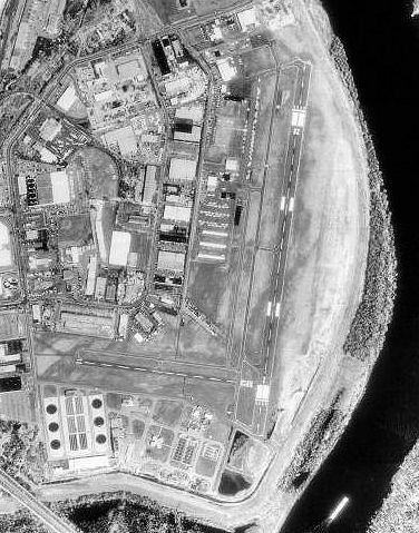
image-width = 300
caption = 23 April 1990

image2-width = 150
caption2 = FAA airport diagram
IATA = HFD
ICAO = KHFD
FAA = HFD
type = Public
owner = Connecticut Department of Transportation (ConnDOT)
operator =
city-served =
location =Hartford, Connecticut
elevation-f = 18
elevation-m = 5
coordinates = coord|41|44|12|N|072|38|58|W|type:airport|display=inline
website =
r1-number = 2/20
r1-length-f = 4,417
r1-length-m = 1,346
r1-surface = Asphalt
r2-number = 11/29
r2-length-f = 2,314
r2-length-m = 705
r2-surface = Asphalt
h1-number = H1
h1-length-f = 70
h1-length-m = 21
h1-surface = Asphalt
r3-number = NE/SW
r3-length-f = 2,309
r3-length-m = 704
r3-surface = Turf
stat-year = 2001
stat1-header = Aircraft operations
stat1-data = 120,217
stat2-header = Based aircraft
stat2-data = 144
footnotes = Source:Federal Aviation Administration FAA-airport|ID=HFD|use=PU|own=PU|site=02827.*A, effective 2007-07-05]Hartford-Brainard Airport Airport codes|HFD|KHFD|HFD is a Class D, towered public
airport located three miles (5 km) southeast of downtown Hartford, in Hartford County,Connecticut ,United States . It is owned by the Connecticut Department of Transportation (ConnDOT).Facilities and aircraft
Hartford-Brainard Airport covers 201
acre s (81 ha) which contains threerunway s and onehelipad :
* Runway 2/20: 4,417 x 150 ft (1,346 x 46 m), Surface:Asphalt
* Runway 11/29: 2,314 x 71 ft (705 x 22 m), Surface: Asphalt
* Runway NE/SW: 2,309 x 150 ft (704 x 46 m), Surface: Turf (Closed during winter months from November 2 to April 30 except for Ski-Equipped aircraft or helicopter training.)
* Helipad H1: 70 x 77 ft (21 x 23 m), Surface: AsphaltFor the 12-month period ending June 12, 2001, the airport had 120,217 aircraft operations, an average of 329 per day: 99%
general aviation , 1%air taxi and <1% military. There are 144 aircraft based at this airport: 87% single engine, 10% multi-engine, 1% jet aircraft, 1%helicopter s and 1%glider s.See also
*
Bradley International Airport (BDL)Fixed base operator and flight schools
* [http://www.atlanticaviation.com/ Atlantic Flight Service] - FBO
* [http://metroflightct.com/ Metro Flight Services, LLC]
* [http://www.premierflightct.com/ Premier Flight Center]ee also
*
Connecticut World War II Army Airfields References
External links
* [http://www.ct.gov/dot/cwp/view.asp?q=260082 Hartford-Brainard Airport] at Connecticut DOT website
*WikiMapia|41.7367|-72.6494|13
*FAA-diagram|00189
*US-airport-ga|HFD
Wikimedia Foundation. 2010.