- Interstate 95 in Connecticut
-
This article is about the section of Interstate 95 in Connecticut. For the entire length of the highway, see Interstate 95.
Interstate 95
Jewish War Veterans Memorial Highway 
Route information Maintained by ConnDOT Length: 111.57 mi[1] (179.55 km) Major junctions South end:  I-95 in Port Chester, NY
 US 7 in Norwalk

 Route 8 / Route 25 in Bridgeport
 I-91 in New Haven
 Route 9 in Old Saybrook
 I-395 in East Lyme
North end: I-95 in Hopkinton, RIHighway system Main route of the Interstate Highway System
Main • Auxiliary • BusinessRoutes in Connecticut
Special Service Roads • State Roads←  Route 94
Route 97  →
→Interstate 95, the main north–south Interstate Highway on the East Coast of the United States, runs in a general east–west compass direction for 111.57 miles (179.55 km) in Connecticut from the Rhode Island state line to the New York State line. I-95 Southbound from East Lyme to the New York State is part of the Connecticut Turnpike. I-95 Northbound begins at the New York state line at Greenwich and leaves the Turnpike in East Lyme near New London, and continues east to the Rhode Island State line. This stretch of I-95 is known as the Jewish War Veterans Memorial Highway.[2]
Contents
Route description
Interstate 95 enters Connecticut as the Connecticut Turnpike in Greenwich at the New York state line. The Connecticut Turnpike stretches for 128 miles (206 km) across the state, but only the first 88 miles (142 km) of the Connecticut Turnpike is signed as I-95. The Turnpike portion of I-95 passes through the most heavily urbanized section of Connecticut along the shoreline between Greenwich and New Haven, going through the cities of Stamford, Norwalk, Bridgeport, and New Haven, with daily traffic volumes of 120,000 to over 150,000 throughout the entire 48-mile (77 km) length between the New York state line and the junction with I-91 in New Haven.[citation needed] The Turnpike intersects with several major expressways, namely U.S. Route 7 at Exit 15 in Norwalk, Route 8 at Exit 27A in Bridgeport, the Merritt and Wilbur Cross Parkways at Exit 38 (via the Milford Parkway) in Milford, and Interstate 91 at Exit 48 in New Haven.
North (east) of I-91, the Turnpike continues along the Connecticut shoreline with a smaller amount of volume. The six-lane highway is reduced to four lanes in Branford, interchanges with Route 9 at Exit 69 in Old Saybrook, crosses the Connecticut River on the Baldwin Bridge and continues until the interchange with Interstate 395 at Exit 76 near the East Lyme-Waterford line. After Exit 76, the Turnpike continues on I-395 while I-95 continues east through New London, Groton, Stonington, and North Stonington towards the Rhode Island State line.
Going southbound, the last exit before the Connecticut Turnpike segment is Exit 80 for Oil Mill Road. The first exit northbound is Exit 81 for Cross Road. Just before the Cross Road exit is a weigh station. The road then enters Waterford and intersects with Route 85 at Exit 82. Exit 82A northbound is for a Frontage Road of I-95 and has access to shopping malls. Exit 83 differs in each direction. Going southbound, Exit 83 is for U.S. Route 1, the Frontage Road and the shopping malls. Going northbound however, Exit 83 is for Route 32 (Connecticut) and downtown New London.
Exits 84S, 84N and 84E, only going southbound, are for Route 32, Norwich and downtown New London. Exit 85 is northbound only and is for U.S. Route 1 and is accessible off the Gold Star Bridge, which crosses the Thames River. Exit 86 is in both directions for Routes 12 and 184 in Groton. Accessible from Exit 86 is the Groton Sub Base. Exit 87 is for Route 349, also known as the Clarence B. Sharp Memorial Highway. A mile after Exit 87, Exit 88 leaves for Route 117 in Noank. Just short of three miles (5 km) later, I-95 enters Mystic and interchanges with Allyn Street at Exit 89 and Route 27 at Exit 90. Route 234 interchanges three miles (5 km) after Exit 90 at Exit 91. Exit 92 is for Routes 2 and 49. An attraction off Exit 92 is a Foxwoods Casino. Exit 93 is the final exit before Rhode Island and is for Routes 216 and 184. Interstate 95 then enters Rhode Island at 111 miles (179 km).
Auxiliary routes
- Interstate 395 is I-95's only spur in Connecticut, it's also part of the Connecticut Turnpike which runs continues Northbound to Danielson, where it continues north to the Massachusetts State Line where it meets Interstate 90 Massachusetts Turnpike and Interstate 290 south of Worcester, Massachusetts. At the split in Danielson, the Turnpike again turns east, merging with U.S. Route 6 near the Rhode Island state line; that short spur is unsigned Route 695, but the inclusion of 95 in its number is coincidental.
Disasters
In January 1983, a truck with a brake failure slammed into a line of cars waiting to pay a toll on I-95 in Stratford, Connecticut. Seven people were killed. This accident helped lead to the removal of toll barriers throughout Connecticut, which was completed six years after.
On the morning of June 28, 1983, a 100 foot (30 m) section of the Mianus River Bridge in Cos Cob collapsed, plunging northbound I-95 traffic into the Mianus River below, killing three. The collapse was blamed on the failure of the steel pins to hold the horizontal beams together and inadequate inspection prior to the collapse. Northbound traffic was diverted on this section of I-95 for 25 days. Southbound traffic was unaffected.
On March 26, 2004, a bridge on I-95 in Bridgeport, Connecticut was partly melted by the explosion of a tanker truck carrying over 11,900 gallons (45,000 L) of fuel oil. Repairs were estimated to take at least two weeks, but the highway was opened to northbound traffic in only a few days. Southbound traffic resumed about a week later.
At 10:20 AM on November 2, 2007, a tanker truck, carrying heating oil plowed over the divider, knocking the side of a tractor trailer's trailer and striking several other cars in its path. Three people were killed, including the driver of the tanker and the occupants of two cars that were completely destroyed in the crash. The driver of the tractor trailer survived (his Pit Bull canine companion emerged completely unharmed) but the trailer of the tractor trailer was split open. At least three other cars were involved in this accident. A part of the road was damaged and took until the next morning to fully reopen, partly due to a cleanup after the accident.
History
Interstate 95 in Connecticut, particularly in Fairfield and New Haven Counties, has far more exits than typical Interstate Highways, with some exits less than one mile (1.6 km) apart. State transportation officials have said the reason for the many exits stems from the state's original justification for building parts of the highway — to ease traffic congestion on Route 1 by providing a faster, alternate route, even for drivers traveling short distances within the same community. Rather than skirting urban areas, the highway was built directly through the most dense sections of Stamford, Norwalk, Bridgeport and New Haven.
While most of I-95 was built as the Connecticut Turnpike, the Connecticut Turnpike incorporated several pieces of already-built relocations, some to freeway standards, of U.S. Route 1 (the Turnpike split from the US 1 relocation in East Lyme, along the Old Lyme-New London section):
- Darien bypass, opened ca. 1952
- New Haven east of the Quinnipiac River, opened ca. 1951
- Old Saybrook-Old Lyme Raymond E. Baldwin Bridge over the Connecticut River and approaches, opened 1948
- Old Lyme-New London, opened by 1950 as a two-lane road
- New London-Groton Gold Star Bridge over the Thames River and approaches, opened 1943
Other improvements in the corridor included the New York-Meriden Merritt Parkway/Wilbur Cross Parkway, New Haven-Old Saybrook Route 80, and Groton-Rhode Island Route 184, the latter connecting in Rhode Island to Route 3, a shortcut to Providence.
Most of the Turnpike opened January 2, 1958, and was designated I-95 south/west of the split with the relocated US 1 by 1959. The rest of I-95 to Rhode Island opened December 12, 1964. The Gold Star Bridge was twinned ca. 1975, along with a reconstruction of its approaches, and in 1993 the Raymond E. Baldwin Bridge was replaced with a wider span.
The state installed cameras to watch traffic along the highway in the early 1990s. As of 2007, about 100 cameras have been set up and are monitored by state police and the state Department of Transportation. In Fairfield County, local emergency responders (fire departments and ambulance services) that serve the highway in individual towns have asked for direct feeds from the cameras to avoid mistakes. When travelers report an accident, they sometimes tell authorities that it occurred near an exit that is actually not the nearest to the scene, slowing down response time. The traffic feed from the cameras is available on the World Wide Web, but the service can be spotty, according to the Stamford, Connecticut and Norwalk, Connecticut fire chiefs, who said they were hoping that a proposed $40 million upgrade of the camera system, under consideration by the state in 2007, would provide them access.[3] Feeds from these cameras are also used by local media outlets, as part of traffic report segments in news programming, and in some instances as a part of a designated"Traffic and Weather" Channel.
Construction plans
While the corridor was designated "High Priority Corridor 65" in 2005, work along Interstate 95 in Connecticut has been ongoing for nearly 15 years.
Interstate upgrades
- Replace the bridge over the Connecticut River in Saybrook (completed in 1993)
- Replace the bridge over the Saugatuck River in Westport (completed in 2001)
- Widening and reconstruction of I-95 through Bridgeport (completed in 2006)
- Upgrade the median divider from New York State line to Waterford to meet current safety standards (segmented construction ongoing since 1993)
- Construction of a new extradosed Q Bridge (Pearl Harbor Memorial Bridge) over the Quinnipiac River (underway)
- Reconfiguring the interchange between I-91, I-95, and Route 34 in New Haven (underway)
- Replace bridge over the West River in New Haven (to start in 2009)
- Reconstruct I-95/I-395 interchange in Waterford to accommodate proposed Route 11 Expressway connection (in planning).
- Replacement of the Moses Wheeler Bridge over the Housatonic River (to start in 2009)
- Widening and reconstruction of I-95 between Norwalk and Stamford — in December 2007 a 15-month, $5.5 million project was completed to add fourth (or "operational") lanes in each direction between the entrances and exits at Exits 10 and 11 in Darien. This project was completed in 2007. A similar project between Exits 11 and 13 began in 2008 and is scheduled for completion in 2010. An earlier project added a fourth lane on the southbound side from the entrance at Exit 10 to Exit 8. After that lane was added, a state Department of Transportation study concluded that accidents were down on that stretch of the highway by 20 percent, amounting to about 160 fewer accidents per year. Construction of operational lanes at exits 11, 12, and 13 was expected to begin in the late spring of 2008.[4]
- Widen I-95 mainline from Branford to the Rhode Island state line
Mass transit upgrades
These projects have been undertaken in large part to reduce traffic on the highway, which is often congested, particularly in Fairfield County:
- New train station near the Fairfield/Bridgeport city line (construction started May 2006)
- Intermodal Transportation Center in Bridgeport (Completed)
- New train stations in Orange and West Haven (in planning)
- Upgrade catenary power lines along the New Haven Line
- New train station in Madison
- Purchase new railroad cars and refurbish existing cars to increase capacity and reliability
- Construct new container barge ports at Bridgeport and New Haven
- Expansion of freight service on the New Haven Line
- Replace outdated bridges and straighten various sections of the New Haven Line to accommodate the Acela Express 150 MPH (240 km/h) operating speed.
Exit list
County Location Mile Exit Destinations Notes Fairfield Greenwich 0.00 I-95 southContinuation into New York; southwestern end of the Connecticut Turnpike concurrency 0.78 2 Delavan Avenue – Byram 2 Former toll plaza 2.54 3 Arch Street – Greenwich 3.73 4 Indian Field Road – Cos Cob, Greenwich 5.53 5  US 1 – Riverside, Old Greenwich, Mianus
Stamford 6.50 6 Harvard Avenue Northbound exit and southbound entrance 6.62 6 West Avenue Southbound exit and northbound entrance 7.30 7 Greenwich Avenue  To Route 137
Access to Route 137 via Washington Boulevard (SSR 493); northbound exit and southbound entrance 7.67 8 Atlantic Street Southbound signed as exit 7 to Route 137 (via SSR 493) 8.20 8 Elm Street Southbound exit and northbound entrance 9.28 9  US 1 / Route 106 – Glenbrook
Darien 10.75 10 Norton Road, Ledge Avenue – Noroton 11.61 11 US 1 – Darien, Rowayton12.23 12  Route 136 (Tokeneke Road) – Rowayton
Northbound exit and southbound entrance 13.14 13 US 1 (Post Road)Norwalk 14.83 14 US 1 (Connecticut Avenue)No northbound exit 15.49 15 US 7 – Norwalk, Danbury
South NorwalkSplit northbound into exit 14 (South Norwalk) and exit 15 (US 7) 15.91 Yankee Doodle Bridge over the Norwalk River 16.24 16 East Avenue – East Norwalk 18 Former toll plaza Westport 18.13 17  Route 33 / Route 136 – Westport, Saugatuck
20.36 18 Sherwood Island Connector (SSR 476) to US 1 – Sherwood Island State ParkFairfield 22.88 19 Center Street – Southport Northbound exit and southbound entrance 23.12 19 US 1 – SouthportSouthbound exit and northbound entrance 23.72 20 Bronson Road Southbound exit and northbound entrance 24.38 21 Mill Plain Road 25.03 22 Round Hill Road Northbound exit and southbound entrance 25.21 22  Route 135 (North Benson Road)
Southbound exit and northbound entrance 25.83 23 US 1 (Kings Highway)26.72 24 Black Rock Turnpike (US 1) Connects to Routes 58 and 59 Bridgeport 27.43 25 Commerce Drive, State Street Northbound exit and southbound entrance; off-ramp is within Fairfield 27.64 25  Route 130 (Fairfield Avenue)
Southbound exit and northbound entrance 28.29 26 Wordin Avenue 29.00 27 Lafayette Boulevard – Downtown Bridgeport Northbound exit and southbound entrance 29.03 27A Route 25 / Route 8 – Trumbull, Waterbury29.14 27 Lafayette Boulevard – Downtown Bridgeport Southbound exit and northbound entrance 29.33 P.T. Barnum Bridge over the Pequonnock River 29.86 28  Route 127 (East Main Street)
Northbound exit and southbound entrance 30.07 29 Route 130 (Stratford Avenue) / Seaview Avenue31.07 30  Route 113 (Lordship Boulevard)
Northbound exit and southbound entrance Stratford 31.30 30 Surf Avenue – Stratford Southbound exit and northbound entrance 31 Honeyspot Road Northbound exit and southbound entrance 32.29 31 South Avenue Southbound exit and northbound entrance 32.86 32 West Broad Street – Stratford 33 Former toll plaza 33.91 33  US 1 / Route 110 / Route 130 / Ferry Boulevard – Devon
Northbound exit and southbound entrance Housatonic River 34.54 Moses Wheeler Bridge New Haven Milford 35.37 34 US 1 – Milford, Devon35.85 35 School House Road, Bic Drive 36.69 36 Plains Road 37.45 37 High Street Northbound exit and southbound entrance 37.58 38  Route 15 (Merritt Parkway, Wilbur Cross Parkway via SR 796)
39.12 39 US 1 – Milford, OrangeSigned as exits 39A (south) and 39B (north) 40.25 40 Old Gate Lane (SR 708), Woodmont Road Orange 41.80 41 Marsh Hill Road – Orange West Haven 43.91 42  Route 162 (Saw Mill Road) – West Haven
44 Former toll plaza 44.87 43 Campbell Avenue – Downtown West Haven Northbound exit and southbound entrance 45.19 43  Route 122 (First Avenue, SR 745)
Southbound exit and northbound entrance New Haven 45.90 44 Downtown West Haven (SR 745) Southbound exit and northbound entrance 46.05 45  Route 10 (Boulevard)
Northbound exit signed as exit 44 (Route 10 via Kimberly Avenue) 46.82–
47.2646 Long Wharf Drive, Sargent Drive 47.46–
47.7547  Route 34 west – Downtown New Haven
47.58–
47.9148 I-91 north – Meriden47.83 Pearl Harbor Memorial Bridge over the Quinnipiac River 49.20 50 Woodward Avenue – Lighthouse Point Access to Port Area and Route 337; northbound exit and southbound entrance East Haven 49.79–
50.1851 US 1 (Frontage Road) – East HavenSouthbound is also signed for Lighthouse Point Park 50.53 52  Route 100 (North High Street) – East Haven
Southbound exit and northbound entrance Branford 51 Former toll plaza 52.33 53 
 US 1 / Route 142 / Route 146 (via SR 794) – Short Beach
Northbound exit and southbound entrance 53.23 54 Cedar Street (SR 740) – Branford 55.18 55 US 1 (East Main Street) – North Branford56.25 56 Leetes Island Road – Stony Creek Guilford 59.32 57 US 1 (Boston Post Road) – North Branford60.23 58  Route 77 – North Guilford, Guilford
61.49 59 Goose Lane (SR 718) Madison 63 Former toll plaza 63.48 60 Mungertown Road Southbound exit and northbound entrance 64.73 61  Route 79 – North Madison, Madison
66.43 62 Hammonasset Connector – Madison Exit to Hammonasset State Park Middlesex Clinton 68.61 63  Route 81 – Clinton, Killingworth
Westbrook 70.78 64  Route 145 (Horse Hill Road) – Clinton
73.14 65  Route 153 – Westbrook
Old Saybrook 74.40 66  Route 166 (Spencer Plain Road)
75.92 67 Elm Street Southbound exit and northbound entrance 76.73 67  Route 154 – Old Saybrook
Northbound exit and southbound entrance 77.80 68 US 1 south – Old SaybrookSouth end of US 1 overlap 78.06 69 Route 9 north – Essex, Hartford78 Former toll plaza Connecticut River 78.68 Baldwin Bridge New London Old Lyme 79.15 70  US 1 north / Route 156 – Old Lyme, Hamburg, Laysville
North end of US 1 overlap 83.49 71 Four Mile River Road – Old Lyme, East Lyme East Lyme 84.02 72 Rocky Neck Connector (SSR 449) – East Lyme 85.79 73 Society Road – East Lyme 87.27 74  Route 161 – Flanders, Niantic
88.05 75 US 1 – Waterford, Flanders88.48 76 I-395 north (Connecticut Turnpike) – Norwich, PlainfieldNorthbound exit and southbound entrance; northeast end of Connecticut Turnpike concurrency Waterford 88.88 80 Oil Mill Road – Waterford Southbound exit and northbound entrance 90.12 81 Cross Road – Waterford 91.79 82  Route 85 (Broad St.) – Waterford, Chesterfield
92.26 82A Frontage Roads – New London Unsigned SR 623 (North Frontage) and SR 624 (South Frontage); milepost at northbound off-ramp; southbound exit is via exit 83; access to the shopping malls New London 92.75–
93.1583 US 1 south (Colman Street) – Ocean Beach
Briggs Street (SR 636)South end of US 1 overlap; northbound exit is via exit 82A; access to Coast Guard Academy 93.35–
93.4884  Route 32 – Quaker Hill, Downtown New London
Williams Street (SR 635) – New LondonSigned southbound as exits 84S (Route 32 south), 84N (Route 32 north), and 84E (Williams Street); northbound exit is signed as exit 83; access to the Hodges Square and State Pier Thames River Gold Star Bridge Groton 94.63 85 US 1 north – Downtown Groton
Thames StreetNorth end of US 1 overlap; northbound exit and southbound entrance; southbound access to US 1 north is via exit 87 95.33 86 
 Route 12 / Route 184 – Gales Ferry, Old Mystic
Access exit to Naval Submarine Base New London 95.98 87  Route 349 south (Clarence B. Sharp Highway) – Groton
97.48 88  Route 117 – Poquonock Bridge, Ledyard
100.07 89 Allyn Street – West Mystic, Old Mystic, Groton Long Pt., Noank SR 614 Stonington 101.29 90  Route 27 – Mystic, Old Mystic
Access to Mystic Aquarium and Seaport 104.23 91  Route 234 / North Main Street – Stonington Borough
106.25 92  Route 78 east – Pawcatuck
Future Interchange North Stonington 107.77 93  Route 2 – North Stonington, Pawcatuck
108.61 94  Route 49 – Pawcatuck, Clarks Falls
111.34 95  Route 216 to Route 184 – Clarks Falls, Ashaway I-95 north
Continuation into Rhode Island 1.000 mi = 1.609 km; 1.000 km = 0.621 mi Scenic overlook
Between exits 89 and 90 eastbound is the Jerome Hoxie Scenic Overlook. This overlooks Mystic Cove.
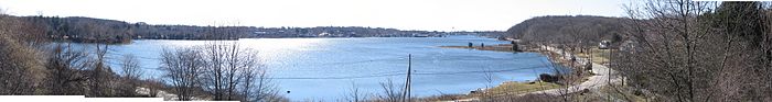 Panaramic View from the Jerome Hoxie Scenic Overlook. Photos were taken in March of 2006.
References
- ^ Route Log - Main Routes of the Eisenhower National System Of Interstate and Defense Highways - Table 1
- ^ Connecticut Special Acts 1996, Connecticut State Library, Accessed July 30, 2008
- ^ Ginocchio, Mark, "Local leaders want access to DOT cameras", The Advocate of Stamford, Connecticut, July 15, 2007, pp 1, A6
- ^ Lucas, Jonathan, "I-95 lanes open in time for holidays: Project aims to ease congestion in Darien", article in 'The Advocate of Stamford, Connecticut, December 8, 2007, pp 1, A4, Norwalk edition
External Links
Interstate 95Previous state:
New YorkConnecticut Next state:
Rhode IslandCurrent Categories:- Interstate Highways in Connecticut
- Interstate 95
- Transportation in Fairfield County, Connecticut
- Transportation in New Haven County, Connecticut
- Transportation in Middlesex County, Connecticut
- Transportation in New London County, Connecticut
- Freeways in the United States


Wikimedia Foundation. 2010.