- West Haven, Connecticut
-
- "West Haven" redirects here. For other uses, see West Haven (disambiguation)
West Haven, Connecticut — City — 
SealLocation in New Haven County, Connecticut
Coordinates: 41°16′26″N 72°58′04″W / 41.27389°N 72.96778°WCoordinates: 41°16′26″N 72°58′04″W / 41.27389°N 72.96778°W Country United States State Connecticut Region South Central Connecticut Incorporated (town) 1921 Incorporated (city) 1961 Government - Type Mayor-council - Mayor John M. Picard Area - Total 11.0 sq mi (28.5 km2) - Land 10.8 sq mi (28.1 km2) - Water 0.2 sq mi (0.4 km2) Elevation 33 ft (10 m) Population (2006)[1] - Total 52,721 - Density 4,900/sq mi (1,892/km2) Time zone Eastern (UTC-5) - Summer (DST) Eastern (UTC-4) ZIP code 06516 Area code(s) 203 FIPS code 09-82800 GNIS feature ID 0211953 Website http://www.cityofwesthaven.com/ West Haven is a city in New Haven County, Connecticut, United States. According to 2006 Census Bureau estimates, the population of the city is 52,721.[1]
Contents
History
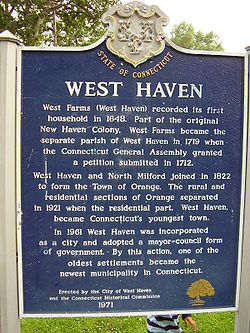
Settled in 1648, West Haven (then known as West Farms) was a part of the original New Haven Colony. In 1719, it became the separate parish of West Haven, but was still officially a part of New Haven until 1822. During the American Revolution, West Haven was the frequent launch and arrival point for raiding parties on both sides of the war. On July 5, 1779 the British invaded New Haven Harbor and came ashore in West Haven and East Haven. Thomas Painter, a teenaged militiaman watching for the approaching British ships while standing atop Savin Rock, is depicted on the city seal. The main commercial street, Campbell Avenue, is named for British Adjutant William Campbell, at the time an Ensign in the Third Guards, who rescued the Reverend Noah Williston, the local Congregational minister and outspoken revolutionary, from being bayoneted by British and Hessian troopers, after he broke his leg trying to escape his captors. Campbell then ordered the soldiers to help the minster back to the parsonage and had the regimental surgeon set his leg. Campbell is also credited with keeping the troops in reasonably good order during their march through the village and reportedly had two soldiers arrested after a local woman accused them of stealing her jewelry. Campbell was killed hours later atop Allingtown Hill on his way to New Haven by a local farmer-turned defender. Campbell is buried in the Allingtown section of town off of Prudden Street. Patriot victims of the invasion are buried in the Christ Church and First Society Cemetery. A historical headstone marks Campbell's approximate gravesite and is maintained by the West Haven Historical Society.
While West Haven again attempted to incorporate as its own town in 1784, that attempt failed, primarily due to the protests of neighboring Milford, which opposed North Milford becoming part of the new town. West Haven and North Milford tried again in 1786 and 1787 with the same result. The two finally joined to become Orange (incorporated as a town in 1822). In 1921, West Haven split from Orange to become a separate town. It was incorporated as a city in 1961 and is known as "Connecticut's Youngest City.",[2] but it is ironically one of the state's oldest settlements.
The Savin Rock section of West Haven was the site of the Savin Rock Amusement Park, which began in the late 19th century as a regionally renowned seaside resort. It evolved into a general amusement park in the 20th century and eventually closed in the 1960s. The park ran along the west side of New Haven Harbor beachfront and is today a walk and bike path. One of the last reminders of the area is Jimmies of Savin Rock, a restaurant known for its seafood and split hot dogs.
West Haven has a mayor-council form of government. John M. Picard, the city's tenth mayor, was elected in 2005 and re-elected in 2007 & 2009. There are three independent fire districts served by the First Fire Taxation (Center), West Shore and Allingtown Fire Districts. Over the years there have been unsuccessful efforts made to consolidate the fire districts, each of which levies its own tax rate.
In 1986, West Haven observed the Bicentennial of the United States Constitution. During the year-long celebrations, the mayor and council passed numerous resolutions to encourage community involvement, including naming the official ship of West Haven -- the U.S. Navy destroyer USS Edson (DD-946) -- and the city's official flower, the Day Lily. Public schools included curriculum on the Constitution from K-12, and school children were released from class to participate in a Constitution Day parade up Campbell Avenue.[citation needed]
On the National Register of Historic Places
- American Mills Web Shop — 114-152 Orange Ave. (added April 10, 1983)
- Old West Haven High School — 278 Main St. (added November 24, 1985)
- Union School — 174 Center St. (added December 13, 1987)
- Ward-Heitman House — 277 Elm St. (added February 8, 2003)
- West Haven Green Historic District
Geography
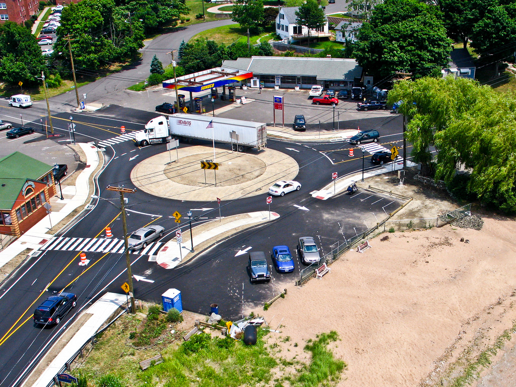
 Kite aerial photo overlooking the West Haven, CT shoreline along Ocean Ave.
 Kite aerial photo overlooking the West Haven, CT shoreline at the Bradley Point and Savin Rock area.
 Kite aerial photo overlooking the West Haven, CT shoreline at Bradley Point.
 Kite aerial photo over the intersection of Jones Hill Road and Ocean Ave.
According to the U.S. Census Bureau, the city has a total area of 11.0 square miles (28.5 km²), of which, 10.8 square miles (28.1 km²) of it is land and 0.2 square miles (0.4 km²) of it (1.54%) is water. West Haven has 3 1/2 miles of publicly accessible beaches, which is one-quarter of the publicly accessible beaches in Connecticut. The hilly Allingtown district of the city is home to the University of New Haven.
West Haven is located in the south-central portion of Connecticut's 3rd congressional district. The city is bound by the southwest by the Oyster River (the boundary between West Haven and Milford since colonial times), northwest by Orange , north by New Haven and northeast by the West River, which divides West Haven and New Haven. To the east is New Haven Harbor and to the south is Long Island Sound.
Principal communities
The three significant neighborhoods in West Haven correspond to the three fire districts. As communities, not all sections of the city fit neatly into these divisions. For example, the southeast corner, while part of the Center aka First Fire Taxation District, is not contiguous to the central business district.
- West Haven center
- Allingtown
- West Shore
Demographics
As of the census[3] of 2000, there were 52,360 people, 21,090 households, and 13,117 families residing in the city. The population density was 4,832.0 people per square mile (1,865.0/km²). There were 22,336 housing units at an average density of 2,061.3 per square mile (795.6/km²). The racial makeup of the city was 74.15% white, 16.29% African American, 0.24% Native American, 2.91% Asian American, 0.05% Pacific Islander, 3.57% from other races and 2.79% from two or more races. 9.09% of the population were Hispanic or Latino of any race.
There were 21,090 households out of which 28.5% had children under the age of 18 living with them, 41.9% were married couples living together, 15.6% had a female householder with no husband present, and 37.8% were non-families. 31.0% of all households were made up of individuals and 10.7% had someone living alone who was 65 years of age or older. The average household size was 2.42 and the average family size was 3.06.
In the city the population was spread out with 23.1% under the age of 18, 9.7% from 18 to 24, 31.2% from 25 to 44, 21.8% from 45 to 64, and 14.2% who were 65 years of age or older. The median age was 36 years. For every 100 females there were 91.3 males. For every 100 females age 18 and over, there were 88.2 males.
The median income for a household in the city was $42,393, and the median income for a family was $51,631. Males had a median income of $38,024 versus $30,610 for females. The per capita income for the city was $21,121. About 6.6% of families and 8.8% of the population were below the poverty line, including 11.8% of those under age 18 and 6.0% of those age 65 or over.
Education and business
West Haven was a shipping and industrial center, known for its buckle shops and, later, Armstrong Rubber Co. The Armstrong Rubber factory now sits empty, except for a few small businesses renting space within. Coleco (originally Connecticut Leather Company- later the toy/video game manufacturer), and Sikorsky Aircraft, a division of United Technologies also had operations in West Haven.
Bayer Pharmaceuticals North America, a branch of Bayer AG, based in Leverkusen, North Rhine-Westphalia, Germany, had a plant in West Haven, but the company announced in 2006 that it was shutting its operations in the city, affecting about 1,000 workers. The 137-acre (0.55 km2) former Bayer campus comprises 17 buildings, mostly in West Haven but partly in Orange. In 2007, Yale University purchased the entire campus for biotechnology, pharmaceutical and other life sciences research.[4]
During the Early 2000s- Wal Mart Corporation established a store in West Haven
Long a blue-collar and middle-class bedroom community of New Haven, West Haven has had financial problems since the 1990s.
West Haven is home to the University of New Haven, a U.S. Veterans Affairs hospital, and Yale Field, a baseball park for the Yale University teams and formerly the homefield for Minor League baseball teams. The Yale Bowl, the home field of the Yale Bulldogs, is in New Haven, near the West Haven border.
The West Haven High School football team was ranked first in the state and fifth in the nation in 1968. West Haven is also home to Notre Dame High School, which is a Roman Catholic all-boys school.
Transportation
Interstate 95, Route 34 (also known as Derby Avenue), and U.S. Route 1 (the Boston Post Road) run through West Haven, between Orange and New Haven. Route 162, which both begins and ends at Route 1, starts in Orange, passes through West Haven, and ends in Milford. A north-south state road, Route 122, begins in New Haven, comprising Forest Road, a stretch of Campbell Avenue and First Avenue up to the junction with I-95. Route 745 begins at that point, turns west at Elm Street and continues into New Haven, ending at Route 10 (Ella T. Grasso Boulevard).
Public transportation is provided by Connecticut Transit New Haven. West Haven Center is served by the various B routes (main service along Campbell Avenue). The B4 service continues to Saw Mill Road and Bull Hill Lane; the B5/B6 services run along Jones Hill Road and terminate at the Baybrook Shopping Center near Oyster River; the B7 service continues to Savin Rock via Second Avenue. The J routes run along the West Haven shore towards Milford. The O route serves the areas along Route 1. The M route serves the Veterans Affairs Hospital.
A rail line, used by Metro-North Railroad and Amtrak, runs through West Haven. The nearest stations are in New Haven and Milford. As of 2006, the Connecticut Department of Transportation was considering building a Metro-North station in West Haven, across from the former Armstrong factory, and in Orange, near the Bayer campus. Recently West Haven has received funds for the station.
Tweed-New Haven Regional Airport is the closest facility offering scheduled air service to West Haven.
Notable natives
- Marian Bergeron, "Miss America" 1933[5]
- Pfc. William A. Soderman (1912–1980), Medal of Honor from World War II. A Navy ship was renamed for him. Born in, enlisted from, and buried in West Haven.[6][7][8]
- Ken Strong, NFL football player, inducted into the Pro Football Hall of Fame in 1967.[9]
- Ulish Booker, NFL football player
- Melanie Chartoff, actress
- Eleanor Estes (1906–1988), author of children's literature
- Douglas Ford (born Fortunato; born 1922) professional golfer
- William L. Hadden, Lieutenant Governor of Connecticut from 1943–45 and Attorney General from 1945–51
- Kevin Heffernan, actor, writer, producer, director, and comedian
- Rob Jackson, NFL football player
- Jamey Jasta, metalcore musician
- Samuel Johnson (1696–1772), clergyman and the first president of the Anglican King's College (which later became Columbia University).
- Rufus Porter (1792–1884), painter, inventor, founder of Scientific American
- Donald Thomas, professional football player
- Smoky Joe Wood (1889–1985), Major League Baseball pitcher
- Tony Sparano, NFL coach
- Jonathan D. Spence , professor of history at Yale University and author specializing in modern Chinese history
References
- ^ a b "Annual Estimates of the Population for All Incorporated Places in Connecticut" (CSV). 2006 Population Estimates. U.S. Census Bureau, Population Division. June 2007. http://www.census.gov/popest/cities/files/SUB-EST2006_9.csv. Retrieved July 15, 2007.
- ^ West Haven Web site
- ^ "American FactFinder". United States Census Bureau. http://factfinder.census.gov. Retrieved 2008-01-31.
- ^ "Yale buys West Haven's Bayer campus" by Cara Baruzzi, New Haven Register, 14 June 2007.
- ^ Web page titled "Miss America - Winter 2003 Newsletter" quotes from an Associated Press story (or, more likely, a picture caption), dated September 14, 1933: "Miss Marian Bergeron, 16-year-old West Haven, Connecticut, girl who won the "Miss America" title in the annual beauty pageant at Atlantic City, New Jersey," accessed March 13, 2007
- ^ "West Haven, Connecticut". Claim to Fame: Medal of Honor recipients. Find a Grave. http://www.findagrave.com/cgi-bin/fg.cgi?page=gr&GRid=7841474. Retrieved 2007-11-01.
- ^ "Medal of Honor recipients - World War II (M-S)". Medal of Honor citations. United States Army Center of Military History. June 8, 2009. http://www.history.army.mil/html/moh/wwII-m-s.html. Retrieved 2007-11-01.
- ^ Web site about Soderman, his Medal of Honor and the ship named for him
- ^ Garber, Greg. "NO. 16: KEN STRONG - A football Giant and more". The Dallas Morning News / Associated Press Sports Edition. http://apse.dallasnews.com/contest1999/writing/100-250.hartford16.html. Retrieved 2006-06-02.
External links
- City of West Haven Website
- West Haven Historical Society
- West Haven Public Library
- Savin Rock Museum
- West Haven Business Directory
- University of New Haven
- U.S. Veterans Affairs Hospital
 State of Connecticut
Topics Index · Culture · Constitution · Delegations · Elections · Geography · Government · History · Images · People · Visitor Attractions
Regions Counties Fairfield · Hartford · Litchfield · Middlesex · New Haven · New London · Tolland · Windham
Cities Ansonia · Bridgeport · Bristol · Danbury · Derby · Groton · Hartford · Meriden · Middletown · Milford · New Britain · New Haven · New London · Norwalk · Norwich · Shelton · Stamford · Torrington · Waterbury · West Haven
Places Municipalities and communities of New Haven County, Connecticut Cities 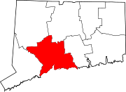
Towns Beacon Falls | Bethany | Branford | Cheshire | East Haven | Guilford | Hamden | Madison | Middlebury | Naugatuck* | North Branford | North Haven | Orange | Oxford | Prospect | Seymour | Southbury | Wallingford | Wolcott | Woodbridge
*Consolidated borough and town
Borough Unincorporated
communitiesDevon | Fair Haven | Heritage Village | Northford | Quaker Farms | Short Beach | South Britain | Stony Creek | Waterville | Westville | Yalesville
Categories:- Cities in Connecticut
- Populated places in New Haven County, Connecticut
- West Haven, Connecticut


Wikimedia Foundation. 2010.