- Interstate 684
-
Interstate 684

Map of New York with I-684 highlighted in redRoute information Length: 28.46 mi[2] (45.80 km) Existed: January 1, 1970[1] – present History: Completed in 1974[citation needed] Major junctions South end:  Hutchinson River Parkway in Harrison, NY
 I-287 at White Plains, NY/Harrison, NY border
 Saw Mill Parkway in Bedford, NY
 I-84 in Southeast, NY
North end:  NY 22 in Southeast, NY
Highway system Auxiliary route of the Interstate Highway System
Main • Auxiliary • BusinessInterstate 684 (I-684) is a 28.4 mile-long (45.7 km) north–south Interstate Highway in the states of New York and Connecticut. The highway connects I-84 with I-287 and the Hutchinson River Parkway, primarily serving commuter traffic to and from the northern suburbs of the New York metropolitan area. The route of the highway was originally designated as part of I-87 during the 1960s. A section of the roadway opened to traffic in October 1968. The final segment finished construction in December 1974.
Contents
Route description
I-684 begins as two separate spur routes. The primary spur (the one officially designated I-684) begins at the White Plains/Harrison line at exit 9A of the Cross-Westchester Expressway (I-287). The other, designated as New York State Route 984J (NY 984J) but still signed I-684, begins in Harrison, New York at exit 26A of the Hutchinson River Parkway and has one independent exit before joining with the I-287 spur into one route. The route follows a northerly course near the New York/Connecticut border, passing the Westchester County Airport, and at one point actually crossing the northwest corner of the Connecticut panhandle for 1.4 miles (2.3 km) without any exits before returning to New York. This brief section is maintained by the New York State Department of Transportation but owned by the Connecticut Department of Transportation.
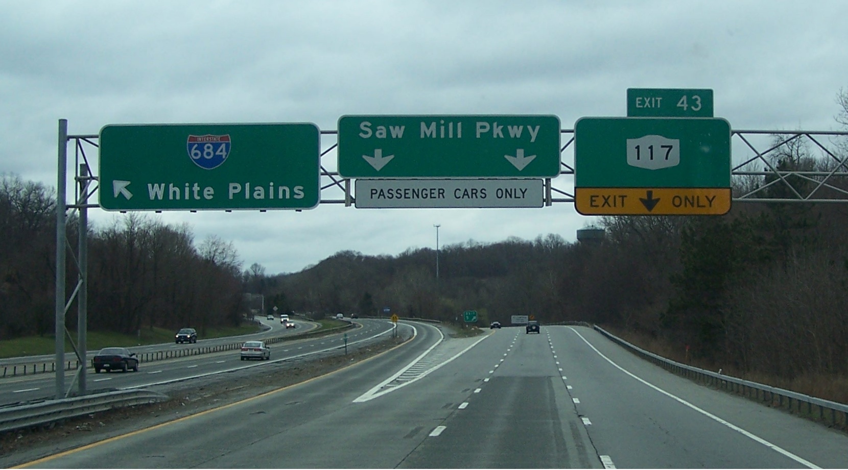
 The 684 C/D road at the Saw Mill and NY 117
Toward the northern border of Westchester County, it meets the northern terminus of the Saw Mill River Parkway. The parkway runs along I-684 for a short distance between its interchange with I-684 and NY 35, where it ends. During this stretch, the Saw Mill Parkway serves as a collector/distributor road for I-684. Once crossing into Putnam County, I-684 interchanges with its parent I-84 in Brewster[3] before making a final interchange at a concurrency of U.S. Route 6 (US 6), US 202, and NY 22, at which point the route terminates and becomes part of NY 22. The speed limit is 65 mph (105 km/h), except on the spur from the Hutchinson River Parkway to just north of the I-287 merge, and just south of the I-84 terminus.
History
An expressway along the NY 22 corridor between White Plains and Brewster was planned by Westchester County in 1956. In 1961, the proposed routing of I-87 north of Elmsford along the east bank of the Hudson River was relocated to use the NY 22 corridor instead via modern I-287 and I-84. After much controversy, the routing of I-87 was approved by the Bureau of Public Roads in December 1964. Construction began soon after the approval with the southernmost section between White Plains and Armonk opened in October 1968. The northernmost section between Purdys and Brewster opened in 1969.
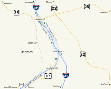 Diagram of interchanges 5 and 6.
On January 1, 1970, I-87 was relocated to follow the New York State Thruway north of Elmsford. The old route was redesignated as I-684.[1] Later that year, a third segment of the new highway between Armonk and Bedford Hills opened to traffic as well. The final segment, which proved to be difficult from an engineering standpoint, was completed in December 1974.
Exit list
County Location Mile[2] Exit Destinations Notes Westchester Harrison 1 Hutchinson River Parkway south – Whitestone BridgeSouthbound exit and northbound entrance Manhattanville Road White Plains/Harrison 0.00 I-287 – Rye, White Plains / Westchester AvenueSouthbound exit and northbound entrance North Castle 4.42 2  NY 120 – Westchester County Airport
Access via Airport Road Fairfield Greenwich I-684 enters Connecticut for 1.4 miles (2.3 km). No exits exist in Connecticut. Westchester North Castle 7.57 3N-S NY 22 – Bedford, ArmonkSingle exit 3 southbound Bedford 12.64 4  NY 172 – Bedford, Mount Kisco
16.75 5  Saw Mill Parkway to NY 117
Southbound exit and northbound entrance 17.71 6  NY 35 – Cross River, Katonah
Lewisboro 19.90 6A  NY 22 to NY 138 – Goldens Bridge
Northbound exit and southbound entrance North Salem 22.36 7  NY 116 to NY 22 – Purdys, Somers
Northbound exit and southbound entrance 8 Hardscrabble Road – Croton Falls, Purdys Putnam Southeast 9E-W I-84 – Newburgh, Danbury28.46 10 
 US 6 / US 202 / NY 22 south NY 22 north
Northbound exit and southbound entrance 1.000 mi = 1.609 km; 1.000 km = 0.621 mi References
- ^ a b State of New York Department of Transportation (January 1, 1970) (PDF). Official Description of Touring Routes in New York State. http://www.greaternyroads.info/pdfs/state70.pdf. Retrieved June 3, 2009.
- ^ a b "2008 Traffic Volume Report for New York State" (PDF). New York State Department of Transportation. June 16, 2009. p. 243. https://www.nysdot.gov/divisions/engineering/technical-services/hds-respository/NYSDOT%20TVR%202008%20by%20Route.pdf. Retrieved February 1, 2010.
- ^ Google, Inc. Google Maps – Interstate 684 (Map). Cartography by Google, Inc. http://maps.google.com/maps?f=q&hl=en&q=brewster,+ny&ie=UTF8&z=14&ll=41.389109,-73.598871&spn=0.032261,0.086002&om=1. Retrieved June 8, 2009.
External links
- Alps' Roads – Interstate 684
- New York Routes – Interstate 684
- Information about I-684 at nycroads.com
Auxiliary routes of Interstate 84 
Browse numbered routes ←  I-678
I-678NY I-690  →
→←  I-395
I-395CT I-691  →Categories:
- Three-digit Interstate Highways
- Interstate Highways in New York
- Interstate Highways in Connecticut
- Transportation in Westchester County, New York
- Transportation in Putnam County, New York
- Interstate 84 (east)


Wikimedia Foundation. 2010.