- Massachusetts Route 12
-
Route 12 
Route information Length: 64.41 mi[1] (103.66 km) Existed: 1922 – present Major junctions South end:  Route 12 in Dudley
North end:  NH 10 at Winchendon
Highway system Massachusetts State Highway Routes
←  Route 11
Route 13  →
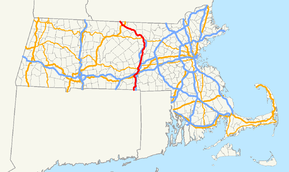
→Massachusetts Route 12 is a north-south state highway that runs through central Massachusetts from the Connecticut state line at Dudley to the New Hampshire state line at Winchendon.
Contents
Route description
Route 12, starting at the Connecticut state line, runs north through the towns and cities of Dudley, Webster, Oxford, Auburn, Worcester, West Boylston, Sterling, Leominster, Fitchburg, Westminster, Ashburnham, and Winchendon.
Route 12 has a junction with Interstate 90 (the Massachusetts Turnpike) at an interchange in Auburn that also includes Interstates 290 and 395 and US 20. Route 12 has an interchange with I-290 in Worcester, and three interchanges with I-190, in Worcester, West Boylston, and Sterling. Route 12 is a minor road in Massachusetts, having been replaced by I-395 from the Connecticut state line to Auburn, I-290 from Auburn to Worcester, and I-190 from Worcester to Leominster.
Town Milepost Junction Notes Dudley 0.0  Route 12
Northern end of Connecticut Route 12.
Southern end of Massachusetts Route 121.7  Route 197
Eastern terminus of Route 197 Webster 3.4 
 Route 16 / Route 193
Western terminus of Route 16; northern terminus of Route 193 Oxford 11.2  Route 56
Southern terminus of Route 56 12.0  US 20
US 20Beginning of concurrency with US 20 Auburn 12.6  US 20
US 20End of concurrency with US 20 13.6 

 I-395 / I-290 / I-90 (Mass. Pike)
I-395 / I-290 exit 7; I-90 exit 10 Worcester 17.6  I-290
I-290Exit 10 – southbound exit/northbound entrance only 19.1  Route 9
Beginning of concurrency with Route 9 20.5 
 Route 122 / Route 122A
Junction of Route 122; beginning of concurrency with Route 122A 21.2  Route 9
End of concurrency with Route 9 22.5  Route 122A
End of concurrency with Route 122A 23.1  I-190
I-190I-190 Exit 1 West Boylston 26.1  I-190
I-190I-190 exit 4 27.9  Route 140
Beginning of concurrency with Route 140 28.8  Route 140
End of concurrency with Route 140 29.0  Route 110
Western terminus of Route 110 Sterling 33.4  Route 62
Beginning of concurrency with Route 62 33.7  Route 62
End of concurrency with Route 62 35.2  I-190
I-190I-190 exit 6 Leominster 40.1  Route 117
Western terminus of Route 117 40.7  Route 13
Southern terminus of Route 13 41.6  Route 2
MA Route 2 exit 31A-B Fitchburg 46.1 
 Route 2A / Route 31
Beginning of concurrency with Routes 2A and 31 47.0 
 Route 2A / Route 31
End of concurrency with Routes 2A and 31 Ashburnham 53.1  Route 101
0.1-mile concurrency Winchendon 59.0  Route 140
Northern terminus of Route 140 61.4  US 202
0.2 mile concurrency 64.41  NH 12
NH 12Northern end of Massachusetts Route 12
Southern end of New Hampshire Route 12.See also
References
- ^ Executive Office of Transportation, Office of Transportation Planning - 2005 Road Inventory
External links
Coordinates: 42°41′3.0″N 72°3′20.3″W / 42.68417°N 72.055639°W
Categories:- Numbered routes in Massachusetts
Wikimedia Foundation. 2010.

