Washington State Route 168
- Washington State Route 168
infobox road
state=WA
type=SR
route=168
previous_type=SR
previous_route=167
next_type=SR
next_route=169
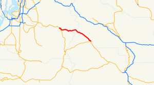
State Route 168 is a proposed highway that would be an alternate route across the Cascade Range. Currently, State Route 410 through Chinook Pass serves this route between Enumclaw and Naches, Washington.
The route would begin in Greenwater, where the White River and Greenwater River meet, travel along Greenwater River, run under the historical Naches Pass through a proposed two-mile tunnel. On the other side, the highway will run alongside the Little Naches River until rejoining State Route 410 a few miles northwest of Cliffdell.
Two major advantages of such a highway are that the route would be an all-year pass, as Chinook Pass is 5,432 feet above sea level, and is closed every winter due to avalanche danger. Also, commercial vehicles, except for explosive cargo, would be permitted, since such vehicles are prohibited within Mount Rainier National Park.
Currently, Forest Service roads 70 and 19 make up much of the proposed alignment. However, the two roads are only connected by an unpaved connector crossing over Pyramid Pass.
References
* [http://apps.leg.wa.gov/RCW/default.aspx?cite=47.17.335 RCW 47.17.335: Legal definition of SR 168]
Wikimedia Foundation.
2010.
Look at other dictionaries:
Washington State Route 410 — State Route 410 Chinook Scenic Byway … Wikipedia
Washington State Route 102 — Infobox WA State Route dir1=West|dir2=East parent type=U.S. parent=101 formed=1984 length mi=2.86|length km=4.6 sec=168|route=102|type=State from=Washington Corrections Center near previous type=US previous route=101 next type=WA next… … Wikipedia
Washington State Route 11 — State Route 11 Chuckanut Drive … Wikipedia
Washington State Route 167 — infobox WA State Route type=WA route=167 sec=330 parent=410 parent type=WA alternate name=Valley Freeway length mi=28.60 length ref= length round=2 formed=1964 dir1=South dir2=North from= junction= to= in Renton previous type=WA previous… … Wikipedia
Washington State Route 100 — Infobox WA State Route dir1=West|dir2=East parent type=U.S. parent=101 formed=1992 length mi=4.68|length ref=Washington State Department of Transportation, [http://www.wsdot.wa.gov/mapsdata/TDO/PDF and ZIP Files/HwyLog2006.pdf State Highway Log] … Wikipedia
Washington State Route 169 — Infobox WA State Route type=State route=169 sec= parent type=WA parent=16 length mi=25.26 length ref= length round=2 formed=1964 dir2=North dir1=South from= to=jct|state=WA|I|405|SR|900 in Renton previous type=WA previous route=168 next type=WA… … Wikipedia
New Jersey Route 168 — Route 168 Black Horse Pike Mount Ephraim Avenue Major highways in the Camden Area with NJ 168 in re … Wikipedia
Virginia State Route 337 — Infobox road state=VA type= route=337 length mi=35.83 length ref=PDFlink| [http://www.virginiadot.org/info/resources/AADT 133 Suffolk 2005.pdf 2005 Virginia Department of Transportation Jurisdiction Report Daily Traffic Volume Estimates City of… … Wikipedia
Pennsylvania Route 168 — PA Route 168 Route information Maintained by PennDOT Length: 55.3 mi[1] … Wikipedia
New York State Route 28 — NY 28 redirects here. NY 28 may also refer to New York s 28th congressional district. NYS Route 28 … Wikipedia
