- Mississippi Highway 25
-
MS Highway 25
Route information Maintained by MDOT Length: 221.142 mi[1] (355.894 km) Major junctions South end: 
 I-55 / US 51 in Jackson
 US 82 in Starkville

 US 45 Alt. in West Point
US 45 in Aberdeen
 US 278 in Amory
 US 78 in Fulton
 US 72 in Iuka
North end:  SR-57 near North Crossroads
Highway system Numbered highways in Mississippi
Interstates • U.S. Routes • State highways
Unsigned state highways←  MS 24
MS 24MS 26  →
→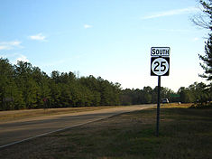 MS 25 as it runs through Rankin County, north of Jackson.
Mississippi Highway 25 runs from I-55 in Jackson, Mississippi to the Tennessee state line north of Iuka. The largely controlled-access part from Jackson to Starkville connects the state capital with the main campus of Mississippi State University.
Contents
History
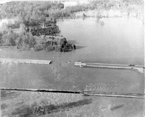 Failure of the Mississippi Highway 25 N/U.S. Route 45 S bridge over the Tombigbee River relief (Big Nichols Creek)/Tennessee-Tombigbee Waterway in Aberdeen, Mississippi during the March 1955 floods.
As of June 28, 2006, 150 miles (240 km) of continuous four-lane divided highway is open between Starkville, Mississippi and Jackson, Mississippi. The last leg to open was the 11.9-mile (19.2 km), $27-million section from the intersection of Highway 19 north of Louisville, Mississippi, to Noxapater Creek in Winston County. This is one of the culminations of the 1987 Four-Lane Highway Program (commonly referred to as AHEAD Program) for improving Mississippi roadways.
On May 10, 2006 the next-to-last leg, a 10.1-mile (16.3 km), $23-million section, opened from the Oktibbeha County line west into Winston County.
Future
All of Highway 25, except for the portion between West Point, Mississippi and Fulton, Mississippi will be an at least four-lane divided highway by the mid-2010s, per Mississippi House Bill 725 of the 1998 session.
Cities on the route
From south to north
- Jackson, Mississippi
- Flowood, Mississippi
- Carthage, Mississippi
- Louisville, Mississippi
- Starkville, Mississippi
- West Point, Mississippi
- Aberdeen, Mississippi
- Amory, Mississippi
- Smithville, Mississippi
- Fulton, Mississippi
- Belmont, Mississippi
- Tishomingo, Mississippi
- Iuka, Mississippi
Junctions
From south to north
Hinds County
Rankin County
 Mississippi Highway 475
 Mississippi Highway 471
 Mississippi Highway 43
Leake County
 Mississippi Highway 13
 Mississippi Highway 16
 Mississippi Highway 429
 Mississippi Highway 35
 Mississippi Highway 427
Winston County
 Mississippi Highway 19
 Mississippi Highway 15 ( joins northbound, splits southbound)
 Mississippi Highway 14
(
joins southbound, splits northbound)Oktibbeha County
 Mississippi Highway 12
 Mississippi Highway 182
- U.S. Route 82 ( joins northbound, splits southbound)
 Mississippi Highway 389
- Mississippi Highway 12 ( joins northbound, splits southbound)
- Mississippi Highway 182
Lowndes County
- U.S. Route 45 Alternate ( splits northbound, joins southbound / ALT joins northbound, splits southbound)
Clay County
( ALT
joins southbound, splits northbound)Monroe County
 Mississippi Highway 382
- U.S. Route 45 ( joins northbound, splits southbound)
 Mississippi Highway 8 ( joins northbound, splits southbound]]
 Mississippi Highway 145
(
joins southbound, splits northbound)(
joins southbound, splits northbound)Itawamba County
- U.S. Route 78 ( joins northbound, splits southbound)
(
joins southbound, splits northbound) Mississippi Highway 178
Tishomingo County
 Mississippi Highway 366
 Mississippi Highway 4
- Natchez Trace Parkway
 Mississippi Highway 30
 Mississippi Highway 364
- U.S. Route 72
 Mississippi Highway 172
 Mississippi Highway 365
 Mississippi Highway 350
See also
- List of Mississippi state highways
References
External links
Categories:- State highways in Mississippi


Wikimedia Foundation. 2010.