- Mississippi Highway 15
-
MS Highway 15
Route information Maintained by MDOT Length: 323.949 mi[1] (521.345 km) Major junctions South end:  US 90 in Biloxi
 I-10 / I-110 in D'Iberville
 US 98 in Beaumont


 I-59 / US 11 / US 84 in Laurel
 US 80 in Newton
 I-20 in Newton
 US 82 in Mathiston
 US 278 in Pontotoc
 US 78 in New Albany
 US 72 in Walnut
North end:  SR-125 near Walnut
Location Counties: Harrison, Stone, Perry, Jones, Jasper, Newton, Neshoba, Winston, Choctaw, Webster, Oktibbeha, Chickasaw, Pontotoc, Union, Tippah Highway system Numbered highways in Mississippi
Interstates • U.S. Routes • State highways
Unsigned state highways←  MS 14
MS 14MS 16  →
→Mississippi Highway 15 (MS 15) is a state highway in Mississippi. At over 328 miles (528 km), it is the longest highway in the Mississippi Highway System. It begins at a junction with U.S. Route 90 in Biloxi and runs northward to the Mississippi/Tennessee state line near Walnut. It serves a total of 15 counties (Harrison, Stone, Perry, Jones, Jasper, Newton, Neshoba, Winston, Choctaw, Webster, Oktibbeha, Chickasaw, Pontotoc, Union, and Tippah). MS 15 is divided into two sections due to a large gap between Stone County and Perry County. The southern section ends at a junction with MS 26, and the northern section begins at a junction with US 98 in Perry County.
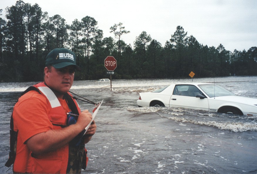
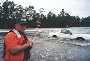 Water flowing over Old Hwy 67 and Mississippi Highway 15 near their intersection in Harrison County on September 29, 1998 during the September 1998 flooding caused on the Tchoutacabouffa River by Hurricane Georges.
Contents
Junctions
From South to North
Harrison County
Stone County
Perry County
 U.S. Highway 98 / Mississippi Highway 198
 Mississippi Highway 42
Jones County
 Mississippi Highway 536
- Interstate 59 / U.S. Highway 84 (both highways splits southbound, joins northbound)
- U.S. Highway 11
- Interstate 59 (I-59 splits northbound, joins southbound)
- U.S. Highway 84 (U.S. 84 splits northbound, joins southbound)
 Mississippi Highway 537
Jasper County
 Mississippi Highway 533
 Mississippi Highway 528
 Mississippi Highway 18
Newton County
 Mississippi Highway 504
- U.S. Highway 80
- Interstate 20
 Mississippi Highway 503
 Mississippi Highway 494
 Mississippi Highway 492
Neshoba County
 Mississippi Highway 485
 Mississippi Highway 21 / Mississippi Highway 488 (MS-21 joins northbound, splits southbound)
 Mississippi Highway 16 (MS-16 joins northbound, splits southbound)
 Mississippi Highway 16 / Mississippi Highway 21 (both join southbound, split northbound)
 Mississippi Highway 19
Winston County

 Mississippi Highway 395 / Mississippi Highway 490
 Mississippi Highway 25 (MS-25 joins northbound, splits southbound)
 Mississippi Highway 14
 Mississippi Highway 25 (MS-25 joins southbound, splits northbound)
Choctaw County
Webster County
 U.S. Highway 82 / Mississippi Highway 403
 Mississippi Highway 50
- Natchez Trace Parkway
 Mississippi Highway 46
Chickasaw County
 Mississippi Highway 340
 Mississippi Highway 8
 Mississippi Highway 32
Pontotoc County
 Mississippi Highway 41
 Mississippi Highway 9 / Mississippi Highway 338
 Mississippi Highway 336
 Mississippi Highway 6 / U.S. Route 278
 Mississippi Highway 346
 Mississippi Highway 345
Union County
 U.S. Highway 78 / Mississippi Highway 30 (MS-30 joins northbound, splits southbound)
 Mississippi Highway 178
 Mississippi Highway 348
 Mississippi Highway 30 (MS-30 joins southbound, splits northbound)
Tippah County

 Mississippi Highway 2 / Mississippi Highway 368
 Mississippi Highway 4 / Mississippi Highway 370
 Mississippi Highway 354
- U.S. Highway 72
- Tennessee State Route 125
References
Categories:- State highways in Mississippi

Wikimedia Foundation. 2010.