- U.S. Route 82
Infobox U.S. Route
article_route=82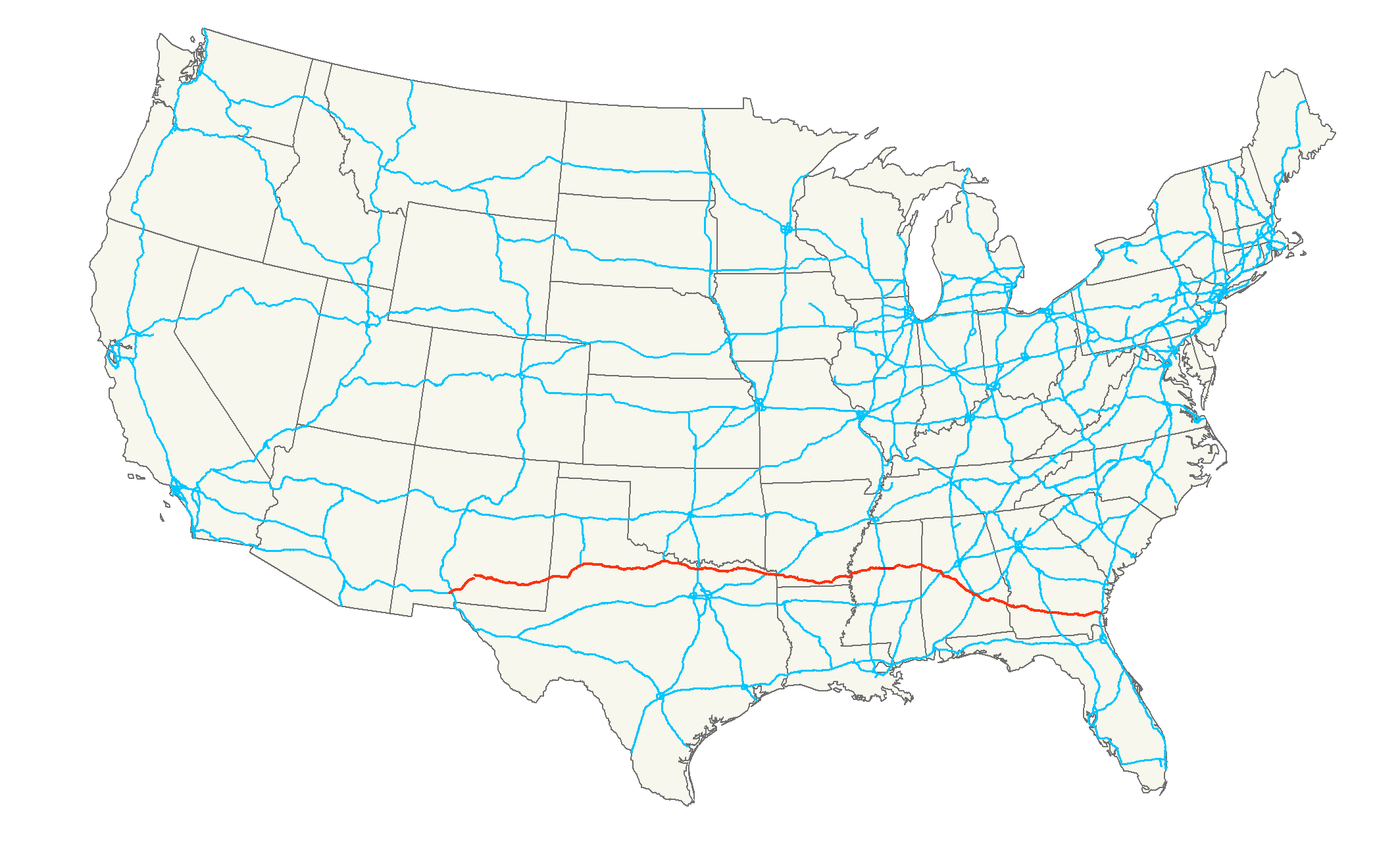
length_mi=1609
length_ref= [http://www.us-highways.com/us1830.htm US Highways from US 1 to US 830] Robert V. Droz]
length_km=2589
yrcom=1932
direction_a=West|direction_b=East
from=Jct|state=NM|US|54|US|70 at Alamogordo, NM
junction=Jct|state=TX|I|27 at Lubbock, TX
Jct|state=TX|I|35 at Gainesville, TX
Jct|state=TX|I|30 near New Boston, TX
Jct|state=MS|I|55 at Winona, MS
Jct|state=AL|I|20|I|59 at Tuscaloosa, AL
Jct|state=AL|I|65 at Montgomery, AL
Jct|state=GA|I|75 at Tifton, GA
to=Jct|state=GA|I|95 at Brunswick, GAU.S. Route 82 is an east-west United States highway in the southern United States. What started as a 1932 addition to the systemDroz, Robert V. [http://www.us-highways.com/usbt.htm U.S. Highways : From US 1 to (US 830)] . URL accessed
19 March 2006 .] across centralMississippi and southernArkansas eventually became a 1,609 mile (2,589 km) route extending from the White Sands ofNew Mexico to Georgia's Atlantic coast.The highway's eastern terminus is in Brunswick, Georgia, at an intersection with Interstate 95. It is co-signed for its last half mile with
U.S. Route 17 . Its western terminus is in Alamogordo,New Mexico at an intersection withU.S. Route 54 andU.S. Route 70 . [http://www.geocities.com/Yosemite%2FFalls%2F3369/HwyEnds/End082/end082.htm Endpoints of US highways] ]Route description
New Mexico
US 82 begins at an intersection with US highways 54 and 70 north of Alamogordo. From there, it generally follows a north-northeasterly bearing until Artesia,where it takes a more due-easterly bearing on through to Lovington, veering back slightly to the north before crossing into Texas.
Texas
Arkansas
US 82 enters Arkansas in downtown Texarkana, then proceeds almost due east across the flat plains of the Red River. It crosses the Red River at Garland City on a new bridge, then passes through the towns of Lewisville and Magnolia. At Magnolia the route joins US 79 for approximately two miles before continuing eastward. The route passes through the cities of El Dorado and Strong before crossing the Ouachita River just north of Lake Jack Lee, then continues through Crossett and Hamburg to
Lake Village . The route continues from there across the Mississippi river toGreenville, MS .Mississippi
Through the entire state, the highway is four-laned with interchanges at major junctions. It crosses the
Mississippi Delta , heading almost due east to Starkville, passing through Indianola and Greenwood, while bypassing Itta Bena. From Starkville east through Columbus and on to the Alabama state line, Hwy 82 is built to freeway standards. At the west end of the state, near Greenville, a new four-laned, cable-stayed Mississippi River bridge has been constructed. The Arkansas and Mississippi approaches are currently under construction and the bridge is expected to open in 2009. Currently a bypass around Greenville andLeland, Mississippi is under construction, the current route of Hwy 82 which goes through Greenville will become U.S. 82 Business. The existing Hwy 82 is expected to become Business 82 through the town. The new bypass will be the southern terminus for the planned freeway spur to the new Interstate 69, which is also under construction through the northern Mississippi Delta. The Mississippi section of U.S. 82 is defined in Mississippi Code Annotated § 65-3-3.Alabama
Throughout Alabama, U.S. 82 is paired with unsigned State Route 6. The highway crosses the state, and is known in West Alabama (Tuscaloosa and Northport) as McFarland Boulevard, in memory of the late Honorable Ward Wharton McFarland, a political, business, and civic leader who died in 1979. Currently in Pickens County, Alabama, a widening project of U.S. 82 is underway to make the highway four-laned. New bridges are being constructed using Federal Highway Administration monies, as well as matching Alabama Department of Transportation funds. Four-laning the highway is also underway in western Tuscaloosa County, Alabama but numerous delays, caused by the lack of commitment of matching funds by the Tuscaloosa County Commission, have added years to the project. Portions of the project site along Highway 82 in western Tuscaloosa County have been excavated and site-readied multiple times, due to repeated holdups associated with the County Commission's funds commitment; as of July, 2008, there has been no action to finish the work. Interestingly, Tuscaloosa County holds the largest county government cash reserves in the state, currently in excess of forty million dollars.
Georgia
Throughout much of southern Georgia, U.S. 82 is paired with State Route 520 and designated as "Corridor Z" and "South Georgia Parkway." West of Dawson, U.S. 82 is paired with Georgia Hwy 50, the historic State Route number for U.S. 82 in Georgia.
History
The east ends of US 82 and
U.S. Route 84 were swapped in 1989 after the roads around Waycross, Georgia, were reconfigured.Most of the Arkansas section was originally Highway 2.
Major intersections
*
U.S. Route 70 andU.S. Route 54 inAlamogordo, New Mexico
*U.S. Route 62 inBrownfield, Texas
*U.S. Route 84 ,U.S. Route 87 andInterstate 27 inLubbock, Texas
*U.S. Route 83 inGuthrie, Texas
*U.S. Route 81 inRinggold, Texas
*Interstate 35 andU.S. Route 77 inGainesville, Texas
*U.S. Route 75 inSherman, Texas
*U.S. Route 69 inBells, Texas
*U.S. Route 271 inParis, Texas
*Interstate 30 inNew Boston, Texas
*U.S. Route 59 ,U.S. Route 67 , andU.S. Route 71 inTexarkana, Texas /Arkansas
*U.S. Route 79 inMagnolia, Arkansas
*U.S. Route 63 andU.S. Route 167 inEl Dorado, Arkansas
*U.S. Route 65 inLake Village, Arkansas .
*U.S. Route 61 inLeland, Mississippi
*U.S. Route 49W inIndianola, Mississippi
*U.S. Route 49E inGreenwood, Mississippi
*Interstate 55 andU.S. Route 51 inWinona, Mississippi
*U.S. Route 45 inColumbus, Mississippi
*U.S. Route 43 inNorthport, Alabama
*Interstate 20 , 59 andU.S. Route 11 inTuscaloosa, Alabama
*U.S. Route 31 andInterstate 65 inPrattville, Alabama
*Interstate 85 andU.S. Route 80 inMontgomery, Alabama
*U.S. Route 29 inUnion Springs, Alabama
*U.S. Route 27 inCuthbert, Georgia
*U.S. Route 19 inAlbany, Georgia
*Interstate 75 andU.S. Route 41 inTifton, Georgia
*U.S. Route 1 ,U.S. Route 23 , andU.S. Route 84 inWaycross, Georgia
*U.S. Route 17 in Brunswickee also
Related routes
*
Mississippi Highway 182
* State Highway 56Bannered and suffixed routes
* U.S. Route 82 Business in
Paris, Texas
*U.S. Route 82 Business inStamps, Arkansas
*U.S. Route 82 Business inMagnolia, Arkansas
*U.S. Route 82 Business inEl Dorado, Arkansas
*U.S. Route 82 Business inAlbany, Georgia
*U.S. Route 82 Business inGreenwood, Mississippi (decommissioned)References
###@@@KEYEND@@@###
Wikimedia Foundation. 2010.