- U.S. Route 45
Infobox U.S. Route
article_route=45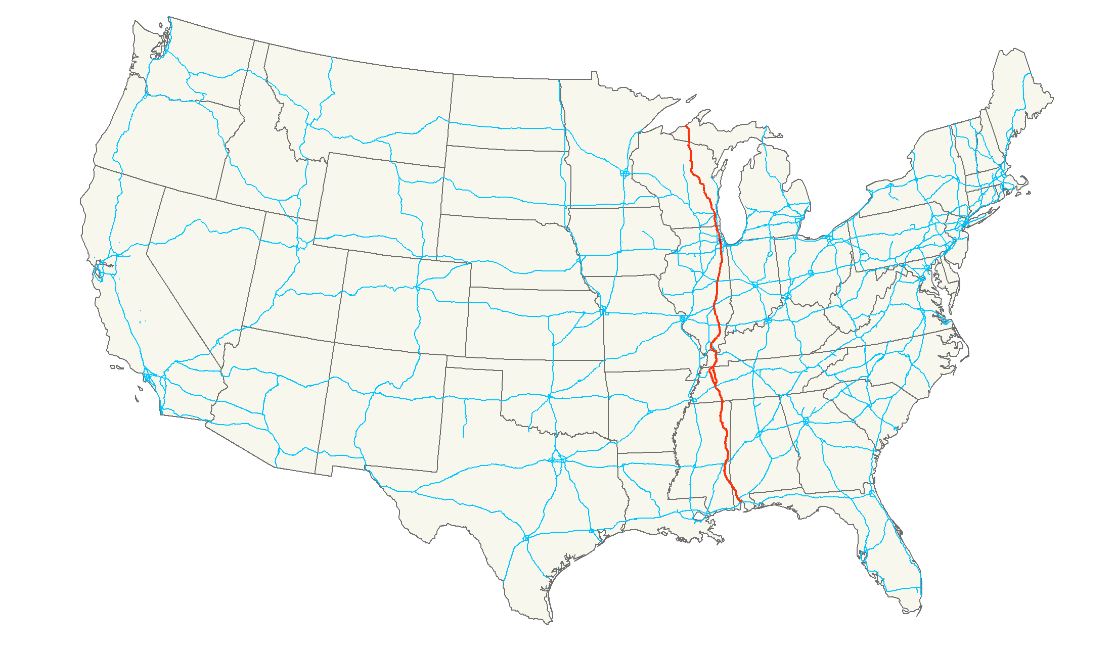
length_mi=1,297Droz, Robert V. [http://www.us-highways.com/usbt.htm U.S. Highways : From US 1 to (US 830)] . URL accessed 02:55, 4 July 2006 (UTC).]
length_km=2,087
yrcom=1926
direction_b=North
direction_a=South
from=Jct|state=AL|US|98 at Mobile, AL
junction=Jct|state=AL|I|65 at Prichard, AL
Jct|state=MS|I|20|I|59 at Meridian, MS
Jct|state=TN|I|40 at Jackson, TN
Jct|state=KY|I|24 at Paducah, KY
Jct|state=IL|I|24 at Metropolis, IL
Jct|state=IL|I|64 at Mill Shoals, IL
Jct|state=IL|I|57|I|70 at Effingham, IL
Jct|state=IL|I|80 near Tinley Park, IL
Jct|state=IL|I|90 at Rosemont, IL
Jct|state=WI|I|43|I|94 at Milwaukee, WI
to=Ontonagon & River Streets in Ontonagon, MIBessert, Christopher J. [http://www.michiganhighways.org/maps/Ontonagon_Changes_2006.html Michigan Highways: Ontonagon State Trunkline Changes 2006] . URL accessed 24 Jun 2007.]
commons=categoryU.S. Route 45 is a north-south
United States highway . US 45 is a border-to-border route, fromLake Superior to theGulf of Mexico . A sign at the highway's northern terminus notes the total distance as 1,300 miles (2,092 km).As of
2006 , the highway's northern terminus is inOntonagon, Michigan , at the corner of Ontonagon and River Streets, a few blocks fromLake Superior . M-64 formerly terminated there as well until its rerouting in October 2006 to use the newly built Ontonagon River Bridge. Its southern terminus is inMobile, Alabama , at an intersection withU.S. Highway 98 .Route description
Alabama
U.S. 45 is co-routed with unsigned State Route 17 between Mobile and Vinegar Bend in Washington County,
Alabama . From Vinegar Bend until theMississippi state line, U.S. 45 is paired with unsignedAlabama State Route 57 .Mississippi
U.S. 45 enters the state at State Line and continues northward through Waynesboro on the way to Meridian. The highway originally went through Quitman and Meridian, but now bypasses both municipalities to the east, since the new four-laned US 45 occupies a new right-of-way.
At Brooksville, U.S. 45 splits with U.S. 45 Alternate and goes through Columbus and Aberdeen before rejoining U.S. 45 Alternate south of Tupelo. U.S. 45 Alternate provides a more direct route between Meridian and Tupelo, bypassing Columbus to the west. US 45 Alternate passes just east of Starkville, home of
Mississippi State University .From Tupelo, the highway bypasses Booneville and Corinth before going into
Tennessee .Highway 45 in Mississippi is designated as a hurricane evacuation route. New construction of connecting roads is underway to enhance this usage by providing an unbroken, four-laned route from Pascagoula on the Mississippi Gulf Coast northward across the entire state, through Tennessee and into Kentucky (see New Development below).
The Mississippi section of U.S. 45 is defined at Mississippi Code Annotated § 65-3-3.
Tennessee
U.S. 45 and 45W are concurrent with unsigned
Tennessee State Route 5 from the Mississippi state line to Union City and then with U.S. 51 (unsigned SR 3) to theKentucky state line. U.S. 45E is co-routed with unsignedTennessee State Route 43 for most of the route's length, except for short segments at Martin and South Fulton where it is cosigned withTennessee State Route 216 andTennessee State Route 215 respectively.Kentucky
U.S. 45 enters
Kentucky in Graves County, where it passes throughMayfield, KY and heads directly north intoPaducah, KY as a four-lane highway. In Paducah, U.S. 45 serves as a major artery, intersecting withInterstate 24 at exit 7, and intersectingU.S. 60 and 62. U.S. 45 leaves Kentucky from Paducah's northern border across a two-lane, metal grate bridge into Illinois across theOhio River .Illinois
In the state of Illinois, U.S. 45 runs from the bridge across the Ohio River east of
Paducah, Kentucky , throughShawnee National Forest and north to the Wisconsin border east ofAntioch, Illinois . With a length of convert|428.99|mi|km|2 in Illinois,cite web |author=Illinois Technology Transfer Center |url=http://www.dot.state.il.us/gist2/select.html |title=T2 GIS Data |accessdate=2007-11-08 |date=2007] U.S. 45 is the longest numbered route in Illinois.Wisconsin
U.S. 45 enters the state in southeast
Wisconsin . It runs concurrent withInterstate 894 andU.S. Route 41 through the west side of metroMilwaukee to form a major artery through the metropolitan area. It runs north to Fond du Lac. The highway routes near the west coast ofLake Winnebago throughOshkosh, Wisconsin . U.S. 45 then travels north through the state and national forests until it exits the state and entersMichigan at Land O' Lakes.Michigan
New Development
Except for short sections near cities, Highway 45 was still almost entirely a two-lane roadway though
Alabama ,Mississippi , andTennessee well into the1980s . In Mississippi, the highway is now completely divided and four-laned (using the 45A alignment, as described above), with the exception of a short four-laned but undivided section through West Point. There remains a mostly two-laned portion of the mainline Highway 45 from Brooksville to the interchange with U.S. Highway 82, but this section is paralled by four-laned 45A. The alternate alignment is in fact a shorter route than the mainline for through traffic.A new routing for sections of
Mississippi Highway 63 andMississippi Highway 57 is planned and under construction to continue the divided highway southward from the point of Highway 45's Mississippi exit at Stateline to Leakesville, then on to the existing four-lanedMississippi Highway 63 from nearLucedale, Mississippi toPascagoula, Mississippi on the Gulf Coast. When complete, the new sections of MS 57 and 63 will greatly enhance Highway 45's utility as a hurricane evacuation route.US 45 bypasses around Corinth, Tupelo, and Meridian are limited-access highways. Except for two stretches of US 45W, which are currently in a survey-and-design stage, all of US 45 in Tennessee has been converted to or replaced by four-lane, often divided, expressways, most of which since the administration of Governor
Ned McWherter , a native ofWest Tennessee who also launched numerous other highway projects, stiffened penalties fordrunk driving , and raised the statespeed limit to 65 mph (100 km/h). From Fulton toMayfield, Kentucky , US 45 is paralleled by theJulian M. Carroll Purchase Parkway , built in the late1960s . From Mayfield to Paducah, Kentucky and between Harrisburg andEldorado, Illinois it is a four-lane divided expressway.Historic termini
Until
1934 , US 45's northern terminus was in theChicago, Illinois area.Prior to the construction of the Interstate Highway system, US 45 was the one of the main routes south out of Chicago toward New Orleans. Much of the traffic left US 45 at
Effingham, Illinois , continuing on throughCairo, Illinois alongIllinois Route 37 .ee also
Bannered and suffixed routes
*
U.S. Route 45E
*U.S. Route 45W
*U.S. Route 45 Alternate inTupelo, Mississippi
*U.S. Route 45 Business inWittenburg, Wisconsin
*U.S. Route 45 Business inNew London, Wisconsin
*U.S. Route 45 Business inPaducah, Kentucky
*U.S. Route 45 Bypass inJackson, Tennessee
*"U.S. Route 45W Business" inTrenton, Tennessee Decommissioned and resigned asTennessee State Route 367
*U.S. Route 45W Business inHumboldt, Tennessee
*U.S. Route 45E Business inMartin, Tennessee
*"U.S. Route 45 Business" inTupelo, Mississippi
*"U.S. Route 45 Business" inMeridian, Mississippi References
External links
* [http://www.geocities.com/usend4049/End045/end045.htm US-45 endpoint photos]
* [http://www.state-ends.com/michigan/us45/ Michigan US-45 endpoints]
* [http://www.michiganhighways.org/listings/MichHwys40-49.html#US-045 U.S. 45 at Michigan Highways]
* [http://illi-indi.com/il_EndsPage.php?id=2045§ion=1 Illinois Highway Ends: US 45]###@@@KEYEND@@@###
Wikimedia Foundation. 2010.