- U.S. Route 72
Infobox U.S. Route
article_route=72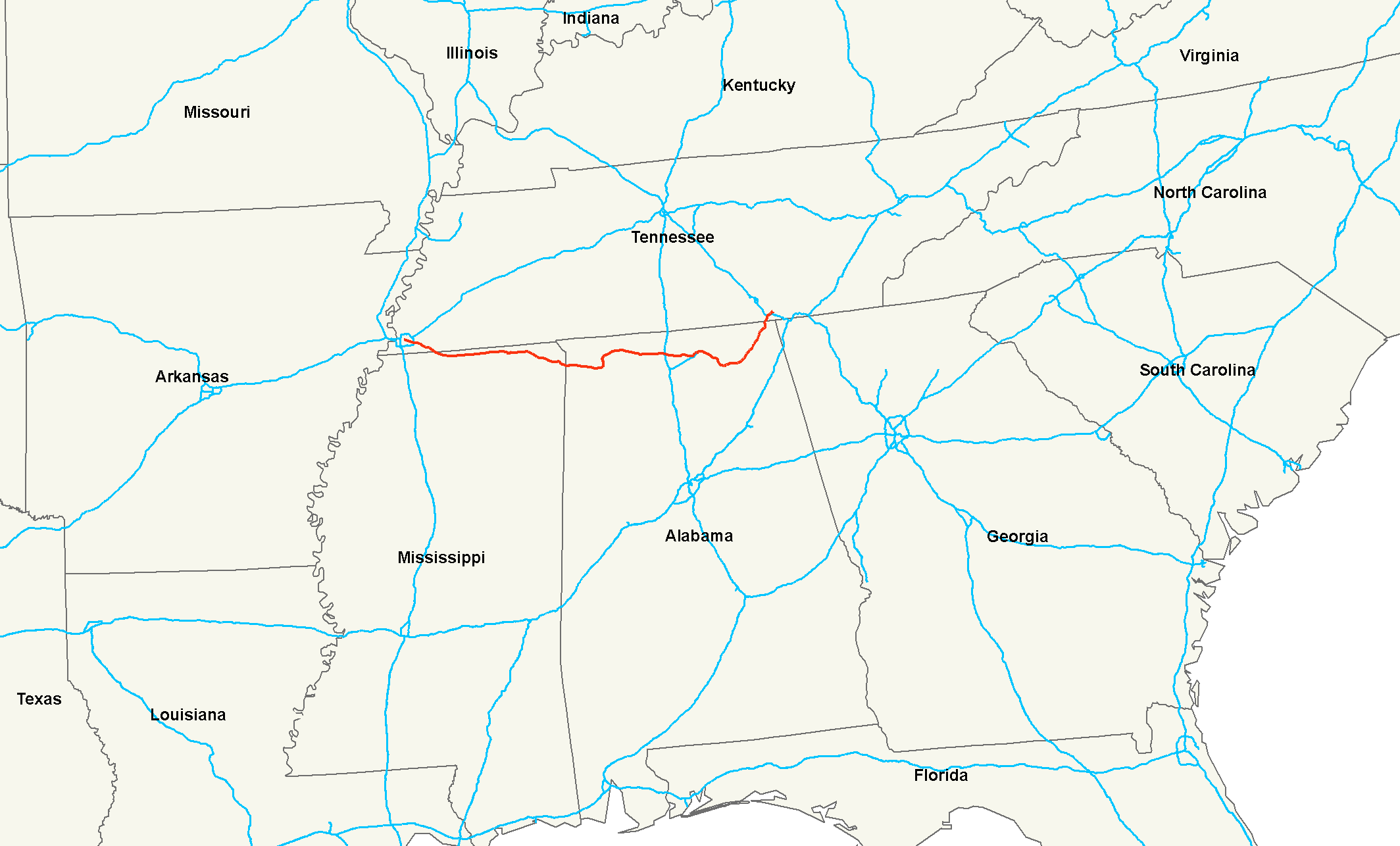
length_mi=337
length_round=0
length_ref= [http://www.us-highways.com/us1830.htm US Highways from US 1 to US 830] Robert V. Droz]
yrcom=1926
direction_a=West
from=Jct|state=TN|US|64|US|70 inMemphis, TN
junction=Jct|state=TN|I|240 at Memphis, TN
Jct|state=MS|US|45 at Corinth, MS
Jct|state=AL|US|43 at Muscle Shoals, AL
Jct|state=AL|US|31 at Athens, AL
Jct|state=AL|I|65 at Athens, AL
Jct|state=AL|US|231|US|431 at Huntsville, AL
Jct|state=AL|I|565 at Huntsville, AL
direction_b=East
to=Jct|state=TN|US|11|US|41|US|64|US|76 inChattanooga, TN U.S. Route 72 is an east-west
United States highway that runs for 337 miles (542 km) from southeastTennessee through northernAlabama and northernMississippi to southwestTennessee . The highway's eastern terminus isChattanooga, Tennessee . Its western terminus isMemphis, Tennessee . It is the only US Highway to have both termini in the same state, yet pass through other states in between.Route description
The highway passes through
Tennessee ,Alabama , andMississippi . Most of the original eastern and western portions of the route through roughly follows the path of theMemphis and Charleston Railroad , a railroad that predated theAmerican Civil War and now operated byNorfolk Southern as their Memphis-Chattanooga mainline. Alternate US 72 follows the Memphis and Charleston route throughNorth Alabama .Tennessee, first entry
US 72 begins at Bellevue Boulevard (U.S. Route 51) in Memphis. From Memphis, the route follows Union Avenue and Poplar Avenue into Collierville. Just south of Collierville, US 72 junctions State Route 385 (the Bill Morris Parkway), a
freeway which links Collierville with I-240. The route entersMississippi three miles (5 km) southeast of SR 385.Mississippi
US 72 enters Mississippi in western Marshall County. The route follows rolling hills across the extreme northern part of the state, passing through Walnut and Corinth as it heads east. Near Burnsville, US 72 crosses the
Tennessee Tombigbee Waterway . Farther east, the route enters theTennessee Valley and heads through Iuka before crossing intoAlabama .Most of US 72 in Mississippi has been upgraded to four-lane highway. Legally, the Mississippi section of US 72 is defined in [http://www.mscode.com/free/statutes/65/003/0003.htm Mississippi Code § 65-3-3] .
Alabama
US 72 enters Alabama just west of Cherokee. The route parallels the
Tennessee River east to Muscle Shoals, where Alternate US 72 splits from US 72. US 72 turns north, passing through Muscle Shoals and crossing the Tennessee River, entering Florence on the opposite bank. From Florence to Huntsville, the route heads through areas dominated by farmland. Between the two locales, however, US 72 enters Athens.Northeast of downtown Huntsville, US 72 interchanges with Interstate 565. I-565/Alternate 72, part of Corridor V of the
Appalachian Development Highway System , terminates at the interchange while US 72 takes over the freeway alignment, joining Corridor V. Strangely enough, I-65 signs both northbound and southbound do not mention Alt US 72 at the I-565 interchange, only I-565 is mentioned as the eastbound route and only AL 20 is mentioned as the westbound route. Signs for I-565 east at this interchange recently were changed to remove any mention of AL 20 east. Most of the US 72 portion of Corridor V is a four-lane dividedexpressway with at-grade intersections. Past Huntsville, US 72 follows several mountain valleys to Scottsboro. From Scottsboro, the route follows a northeasterly routing similar to that of the Tennessee River as it entersTennessee for the second time.All of US 72 within Alabama is four lanes in width. Additionally, much of US 72 has been upgraded through northeast Alabama, with interchanges at the major state highways. Just west of Moores Mill Road in Huntsville, US 72 becomes limited access over Chapman Mountain.
Throughout Alabama, US 72 is paired with unsigned State Route 2.
Tennessee, second entry
US 72 enters Tennessee for the second time just south of South Pittsburg. At South Pittsburg, Corridor V ends at an interchange with
Interstate 24 . US 64, concurrent with I-24 west of the exit, departs the expressway and forms an overlap with US 72 through Kimball to Jasper, where US 41 joins the concurrency. Just east of Jasper, the highways cross the Tennessee River onNickajack Lake . The route then follows a cut in theCumberland Plateau made by the Tennessee River to the western outskirts of Chattanooga, where it interchanges with I-24 once more. Just east of the interchange, US 11 joins the overlap.Together, US 11, US 41, US 64, and US 72 follow the bluffs on
Lookout Mountain above theTennessee River to Chattanooga, where the routes follow Broad Street north into downtown. At the corner of Main Street and Broad Street, US 72 comes to an end; interestingly, US 76 begins at the intersection, making one highway in essence a continuation of the other.US 72 originally went through downtown South Pittsburg on Cedar Avenue.
History
Western Tennessee
Originally, US 72 followed US 45 to Selmer and followed a route west to Memphis. In 1931, US 64 replaced US 72 between Memphis and Selmer. In 1935, US 72 was routed to Memphis through Mississippi from Corinth removing the extension on US 45 to Selmer.
As late as the early 1970s, US 72 followed State Route 57 (Poplar Avenue) from Collierville to its western terminus at East Parkway N. (which carried
U.S. Route 64 ,U.S. Route 70 , andU.S. Route 79 , as well as State Route 1.)Mississippi
* Tishomingo County Road 172 / Quitman Street through Iuka before being bypassed in the mid 1980s.
* An Old US 72 exists south of US 72 between Burnsville and Glen.
* US 72 also followed Alcorn County Road 218 and entered Corinth on Proper Street.
* Until 1935 US 72 followed US 45, now Polk Street / Mississippi State Route 145 north into Tennessee.
* The original 1935 routing west of Cornith followed Mississippi State Route 2 / Kossuth Road to Kossuth before turning west.
* An Old US 72 exists south of US 72 in Benton County from just west of the Tippah County line to just east of the Wolf River near Canaan. The bridge across the Wolf River is closed. The continuation of this segment west of Wolf River to Mississippi State Route 5 is signed Wyatt Road.Alabama
Most of the original US 72 route in Alabama paralleled the
Memphis and Charleston Railroad , a critical route for the South during theAmerican Civil War .cite web |url=http://americancivilwar.com/statepic/tn/tn022.html |title=Collierville Tennessee, American Civil War, November 3, 1863 |accessdate=2007-11-28 |format=html |work= ] cite web |url=http://americancivilwar.com/statepic/tn/tn003.html |title=Shiloh, Pittsburg Landing, Civil War, Tennessee, American Civil War, April 6-7, 1862 |accessdate=2007-11-28 |format=html |work= ] Some sections of the original road were named the Memphis Pike reflecting the idea of connecting Chattanooga toMemphis, Tennessee . The original route also belonged to the original route of theLee Highway . Both of these designations can be found in western Colbert County where sections of the original highway, including parts of Colbert County Route 20 still bear those names. cite map |publisher=Google |title=Google Maps |url=http://maps.google.com/maps?ie=UTF8&hl=en&ll=34.717911,-87.809086&spn=0.025186,0.039911&z=15&om=1 |edition= |year= |cartography= |scale= |series= |page= |section= |accessdate=2007-11-28 |isbn= |id= ]The original route once passed through Tuscumbia on what is named today the Old Lee Highway and Main Street. This route was bypassed in the 1960s.
In Florence US 72 originally followed Huntsville Road to Royal Avenue, then north to Tennessee Street, and finally west to Court Street. Its route was later moved two blocks south through downtown Florence, from Tennessee Street to Dr. Hicks Blvd.
East of Florence the original route is now County Highway 66 through downtown Rogersville and Killen.
Athens' Clinton and Washington Streets hosted a Business 72 route in earlier years. This route was decommissioned in the 1980s.
US 72 has seen several route changes in Huntsville that included a temporary route down Sparkman Drive in the 1960s. Other original routes include Andrew Jackson Way to Holmes Avenue and down Holmes Avenue to reconnect to the original route.
Prior to 1931 US 72 passed through Big Cove between Huntsville and Paint Rock VIA Little Cove Rd/Old "US 431". That route was abandoned for the one used today over Chapman Mountain.
Other original routes include State Route 35 from Woodville to the west side of Scottsboro, State Route 279 east of Scottsboro, and State Route 277 from Stevenson to Bridgeport. State Route 277 carries the distinction of being the last two lane section of US 72 in Alabama. Today the entire route through Alabama has a minimum of four lanes.
Bannered routes
Alternate routes
An Alternate US 72 exists in
Alabama on the south side of theTennessee River between Muscle Shoals and Decatur. Alternate 72 crosses theTennessee River at Decatur along withU.S. Highway 31 and follows the entire route ofInterstate 565 . However signs on I-65 at the I-565 exit make no mention of ALT US 72 and only mention AL 20 westbound from the I-65/I-565 junction. AL 20 was co-signed with Alternate US 72 from Muscle Shoals to Huntsville. AL 20 has since been truncated to the junction of I-65 just east of Decatur. Originally, Alternate US 72 turned off of AL 20 on to AL 53 / Jordan Lane in Huntsville and followed it north convert|1|mi|km|sing=on to rejoin with US 72. With the completion of I-565 in the early 1990s, Alt US 72 was routed along with I-565 to the termination of I-565 at US 72.Alternate U.S. 72 between Decatur and Huntsville Alabama is part of Corridor V of the
Appalachian Development Highway System .ee also
*"
Southern Rock Opera ", aDrive-By Truckers album prominently featuring US 72References
*Rand McNally Road Atlases 1926 - 2006
###@@@KEYEND@@@###
Wikimedia Foundation. 2010.