- Colbert County, Alabama
-
Colbert County, Alabama 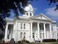 Colbert County Courthouse in Tuscumbia, Alabama
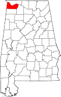
Location in the state of Alabama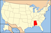
Alabama's location in the U.S.Founded February 6, 1867 Seat Tuscumbia Largest city Muscle Shoals Area
- Total
- Land
- Water
623.61 sq mi (1,615 km²)
594.53 sq mi (1,540 km²)
29.08 sq mi (75 km²), 4.66%Population
- (2010)
- Density
54,428
91/sq mi (35/km²)Website www.colbertcounty.org/ 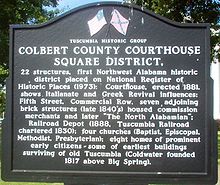 Colbert County Courthouse Square District Historic Marker, September, 2007
Colbert County is a county of the U.S. state of Alabama. Its name is in honor of brothers George and Levi Colbert, Chickasaw Indian chiefs. George Colbert operated a ferry across the Tennessee River in 1790 near present day Cherokee.[1]
The county seat of Colbert County is Tuscumbia. It is part of the Florence - Muscle Shoals Metropolitan Statistical Area known as "The Shoals". As of 2010 the county's population was 54,428.
Contents
History
Colbert County was originally established on February 6, 1867 after it split from Franklin County over political issues after the American Civil War. It was abolished eight months later by an Alabama constitutional convention and then reestablished on February 24, 1870.[1] It is also the location of Ivy Green, the birthplace of noted author Helen Keller.[1] Colbert County is also home of the towns Sheffield and Muscle Shoals where many popular musicians such as Aretha Franklin and the Rolling Stones recorded music.
Geography
According to the 2000 census, the county has a total area of 623.61 square miles (1,615.1 km2), of which 594.53 square miles (1,539.8 km2) (or 95.34%) is land and 29.08 square miles (75.3 km2) (or 4.66%) is water.[2]
Major Highways
 U.S. Highway 43
 U.S. Highway 72
 State Route 20
 State Route 157
 State Route 247
- Natchez Trace Parkway
National protected area
- Natchez Trace Parkway (part)
Rail
River
Adjacent Counties
- Lauderdale County, Alabama - north across the Tennessee River
- Lawrence County, Alabama - southeast
- Franklin County, Alabama - south
- Tishomingo County, Mississippi - west
Demographics
Colbert County, Alabama Year Pop. ±% 1870 12,537 — 1880 16,153 +28.8% 1890 20,189 +25.0% 1900 22,341 +10.7% 1910 24,802 +11.0% 1920 31,997 +29.0% 1930 29,860 −6.7% 1940 34,093 +14.2% 1950 39,561 +16.0% 1960 46,506 +17.6% 1970 49,632 +6.7% 1980 54,519 +9.8% 1990 51,666 −5.2% 2000 54,984 +6.4% 2010 54,428 −1.0% Sources: "American FactFinder". United States Census Bureau. http://factfinder2.census.gov/faces/nav/jsf/pages/index.xhtml. through 1960 As of the census[3] of 2000, there were 54,984 people, 22,461 households, and 16,037 families residing in the county. The population density was 92 people per square mile (36/km2). There were 24,980 housing units at an average density of 42 per square mile (16/km2). The racial makeup of the county was 81.52% White, 16.62% Black or African American, 0.37% Native American, 0.24% Asian, 0.02% Pacific Islander, 0.34% from other races, and 0.89% from two or more races. 1.12% of the population were Hispanic or Latino of any race.
There were 22,461 households out of which 30.50% had children under the age of 18 living with them, 56.00% were married couples living together, 12.10% had a female householder with no husband present, and 28.60% were non-families. 26.10% of all households were made up of individuals and 11.50% had someone living alone who was 65 years of age or older. The average household size was 2.42 and the average family size was 2.92.
In the county the population was spread out with 23.80% under the age of 18, 8.10% from 18 to 24, 27.80% from 25 to 44, 24.90% from 45 to 64, and 15.40% who were 65 years of age or older. The median age was 39 years. For every 100 females there were 91.80 males. For every 100 females age 18 and over, there were 88.10 males.
The median income for a household in the county was $31,954, and the median income for a family was $39,294. Males had a median income of $32,112 versus $20,107 for females. The per capita income for the county was $17,533. About 11.10% of families and 14.00% of the population were below the poverty line, including 18.40% of those under age 18 and 11.90% of those age 65 or over.
Settlements
Cities
Towns
Unincorporated communities
- Allsboro
- Barton
- Buzzard Roost
- Colbert Heights
- Ford City
- White Oak
In popular culture
- Colbert County was featured in a three-part comedy feature on Comedy Central's The Colbert Report from November 28–30, 2006.
See also
- National Register of Historic Places listings in Colbert County, Alabama
- Properties on the Alabama Register of Landmarks and Heritage in Colbert County, Alabama
References
- ^ a b c "Colbert County Website". http://www.colbertcounty.org. Retrieved 2007-05-16.
- ^ "Census 2000 U.S. Gazetteer Files: Counties". United States Census. http://www.census.gov/tiger/tms/gazetteer/county2k.txt. Retrieved 2011-02-13.
- ^ "American FactFinder". United States Census Bureau. http://factfinder.census.gov. Retrieved 2008-01-31.
External links

Lauderdale County Tishomingo County, Mississippi 
 Colbert County, Alabama

Franklin County Lawrence County Municipalities and communities of Colbert County, Alabama Cities 
Towns Unincorporated
communitiesAllsboro | Barton | Ford City | Buzzard Roost
 State of Alabama
Topics - Index
- History
- Geography
- People
- Delegations
- Government
- Governors
- Lieutenant Governors
- Metropolitan Areas
- Visitor Attractions
- National Historic Landmarks
Regions Metros - Greater Birmingham
- Montgomery Metro Area
- Mobile Metro Area
- Huntsville Metro Area
Larger cities Counties - Autauga
- Baldwin
- Barbour
- Bibb
- Blount
- Bullock
- Butler
- Calhoun
- Chambers
- Cherokee
- Chilton
- Choctaw
- Clarke
- Clay
- Cleburne
- Coffee
- Colbert
- Conecuh
- Coosa
- Covington
- Crenshaw
- Cullman
- Dale
- Dallas
- DeKalb
- Elmore
- Escambia
- Etowah
- Fayette
- Franklin
- Geneva
- Greene
- Hale
- Henry
- Houston
- Jackson
- Jefferson
- Lamar
- Lauderdale
- Lawrence
- Lee
- Limestone
- Lowndes
- Macon
- Madison
- Marengo
- Marion
- Marshall
- Mobile
- Monroe
- Montgomery
- Morgan
- Perry
- Pickens
- Pike
- Randolph
- Russell
- Shelby
- St. Clair
- Sumter
- Talladega
- Tallapoosa
- Tuscaloosa
- Walker
- Washington
- Wilcox
- Winston
Coordinates: 34°40′36″N 87°49′02″W / 34.67667°N 87.81722°W
Categories:- Alabama counties
- Florence – Muscle Shoals metropolitan area
- Colbert County, Alabama
- 1867 establishments


Wikimedia Foundation. 2010.