- Montgomery Metropolitan Area
-
Montgomery MSA 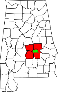
Common name: Montgomery Metropolitan AreaLargest city Montgomery Other cities - Prattville
- MillbrookPopulation Ranked 136th in the U.S. - Total 374,536 (2010)[1] - Density 131.4/sq. mi.
81.63/km²Area 2,786 sq. mi.
4,483 km²State(s) Alabama Elevation - Highest point feet ( m) - Lowest point feet ( m) The Montgomery, Alabama Metropolitan Statistical Area (commonly known as the Montgomery Metropolitan Area or the River Region) is a metropolitan statistical area in central Alabama. As of 2010, the MSA had a population of 374,536, ranking it 136th among United States metropolitan areas.
Contents
Counties
Communities
Places with more than 200,000 inhabitants
- Montgomery (Principal city)
Places with 10,000 to 35,000 inhabitants
Places with 1,000 to 10,000 inhabitants
- Blue Ridge (census-designated place)
- Coosada
- Eclectic
- Fort Deposit
- Hayneville
- Mosses
- Tallassee (partial)
- Wetumpka
- White Hall
- Pike Road
Places with fewer than 1,000 inhabitants
Unincorporated places
Demographics
As of the census[2] of 2000, there were 346,528 people, 129,717 households, and 90,298 families residing within the MSA. The racial makeup of the MSA was 57.32% White, 40.27% African American, 0.31% Native American, 0.77% Asian, 0.03% Pacific Islander, 0.37% from other races, and 0.94% from two or more races. Hispanic or Latino of any race were 1.20% of the population.
The median income for a household in the MSA was $35,567, and the median income for a family was $42,304. Males had a median income of $31,881 versus $22,995 for females. The per capita income for the MSA was $16,996.
Combined Statistical Area
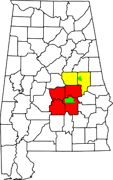 Location of the Montgomery-Alexander City CSA and its components:
 Montgomery Metropolitan Statistical AreaAlexander City Micropolitan Statistical Area
The Montgomery–Alexander City Combined Statistical Area (CSA) is made up of six counties in central Alabama. The statistical area includes one metropolitan area and one micropolitan area. As of the 2000 Census, the CSA had a population of 400,205 (though a July 1, 2009 estimate placed the population at 417,965).[3]
Components
- Metropolitan Statistical Areas
- Montgomery (Autauga, Elmore, Lowndes, and Montgomery counties)
- Micropolitan Statistical Areas
- Alexander City (Coosa and Tallapoosa counties)
Transportation
 Interstate 65
 Interstate 85
 U.S. Highway 31
 U.S. Highway 80
 U.S. Highway 82
 U.S. Highway 231
 U.S. Highway 331
See also
- Table of United States Metropolitan Statistical Areas
- Table of United States Combined Statistical Areas
- Alabama census statistical areas
References
- ^ "Population and Housing Occupancy Status: 2010 publisher = United States Census Bureau, Population Division". http://factfinder2.census.gov/faces/tableservices/jsf/pages/productview.xhtml?pid=DEC_10_NSRD_GCTPL2.US24PR&prodType=table.
- ^ "American FactFinder". United States Census Bureau. http://factfinder.census.gov. Retrieved 2008-01-31.
- ^ "Table 2. Annual Estimates of the Population of Combined Statistical Areas: April 1, 2000 to July 1, 2009 (CBSA-EST2009-02)" (CSV). 2009 Population Estimates. United States Census Bureau, Population Division. March 23, 2010. http://www.census.gov/popest/metro/tables/2009/CBSA-EST2009-02.csv. Retrieved March 24, 2010.
External links
 State of Alabama
Topics - Index
- History
- Geography
- People
- Delegations
- Government
- Governors
- Lieutenant Governors
- Metropolitan Areas
- Visitor Attractions
- National Historic Landmarks
Regions Metros - Greater Birmingham
- Montgomery Metro Area
- Mobile Metro Area
- Huntsville Metro Area
Larger cities Counties - Autauga
- Baldwin
- Barbour
- Bibb
- Blount
- Bullock
- Butler
- Calhoun
- Chambers
- Cherokee
- Chilton
- Choctaw
- Clarke
- Clay
- Cleburne
- Coffee
- Colbert
- Conecuh
- Coosa
- Covington
- Crenshaw
- Cullman
- Dale
- Dallas
- DeKalb
- Elmore
- Escambia
- Etowah
- Fayette
- Franklin
- Geneva
- Greene
- Hale
- Henry
- Houston
- Jackson
- Jefferson
- Lamar
- Lauderdale
- Lawrence
- Lee
- Limestone
- Lowndes
- Macon
- Madison
- Marengo
- Marion
- Marshall
- Mobile
- Monroe
- Montgomery
- Morgan
- Perry
- Pickens
- Pike
- Randolph
- Russell
- Shelby
- St. Clair
- Sumter
- Talladega
- Tallapoosa
- Tuscaloosa
- Walker
- Washington
- Wilcox
- Winston
Coordinates: 32°21′42″N 86°16′45″W / 32.36167°N 86.27917°W
Categories:- Montgomery metropolitan area
- Geography of Montgomery County, Alabama
- Geography of Elmore County, Alabama
- Geography of Autauga County, Alabama
- Geography of Lowndes County, Alabama
- Geography of Montgomery, Alabama


Wikimedia Foundation. 2010.