- Dayton metropolitan area
-
Dayton 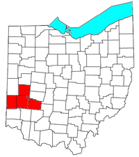
Common name: Metro DaytonLargest city Dayton Other cities - Kettering
- Beavercreek
- Huber HeightsPopulation Ranked 61 st in the U.S. - Total 841,502 - Density 478/sq. mi.
185/km²Area 1,715 sq. mi.
4,445 km²State(s) Ohio Elevation - Highest point feet ( m) - Lowest point feet ( m) The Dayton metropolitan area is the fourth largest metropolitan area in the state of Ohio, behind the largest, Greater Cincinnati, Greater Cleveland, and Greater Columbus.
Contents
Definitions
Dayton Metropolitan Area (also known as the Greater Dayton), as defined by the United States Census Bureau, is an area consisting of four counties in the Miami Valley region of Ohio and is anchored by the city of Dayton. As of 2000 it is the fourth largest metropolitan area in Ohio and the 61st largest Metropolitan Area by Population in the United States. As of the 2010 census, the MSA had a population of 841,502.[1] The larger Dayton–Springfield–Greenville Combined Statistical Area includes Greene County, Darke County, Montgomery County, Miami County, Clark County, and Preble County and had a population of 1,072,891 according to the 2010 Census.[2]
The Dayton-Springfield-Greenville Combined Statistical Area is a CSA in the U.S. state of Ohio, as defined by the United States Census Bureau. It consists of the Dayton Metropolitan Statistical Area (the counties of Montgomery, Greene, Miami and Preble); the Springfield Metropolitan Statistical Area (Clark County); the Urbana Micropolitan Statistical Area (Champaign County); and the Greenville Micropolitan Statistical Area (Darke County). As of the 2010 Census, the CSA had a population of 1,072,891.
- Metropolitan Statistical Areas (MSAs)
- Dayton (Greene, Miami, Montgomery, and Preble counties)
- Springfield (Clark County)
- Micropolitan Statistical Areas (μSAs)
- Greenville (Darke County)
- Urbana (Champaign County)
According to an article in the Cincinnati Enquirer, as Greater Cincinnati grows northward through Butler County, its outer suburbs are expected to expand and begin to overlap the Greater Dayton area.[1] Such a concept has already received the nickname of "Daytonnati."[3] It is part of the Great Lakes Megalopolis containing an estimated 54 million people.
Counties
Cities
Suburbs greater than 30,000
- Kettering - 56,163
- Beavercreek - 45,193
- Huber Heights - 38,101
Montgomery County
 City of Dayton skyline from Woodland Cemetery and Arboretum
Greene County
Miami County
- Bradford (partial)
- Covington
- Piqua
- Pleasant Hill
- Tipp City
- Troy
- West Milton
Preble County
Places with less than 1,000 inhabitants
- Bowersville
- Casstown
- Clifton (partial)
- College Corner (partial)
- Eldorado
- Farmersville
- Fletcher
- Gratis
- Laura
- Ludlow Falls
- Phillipsburg
- Potsdam
- Spring Valley
- Verona
- West Elkton
- West Manchester
Unincorporated places
- Brandt
- Byron
- Chautauqua (partial)
- Conover
- Fairhaven
- Morning Sun
- New Hope
- Phoneton
- Pyrmont
- West Charleston
Townships
Greene County
 Clifton Gorge in John Bryan State Park, near Yellow Springs
- Bath Township
- Beavercreek Township
- Caesarscreek Township
- Cedarville Township
- Jefferson Township
- Miami Township
- New Jasper Township
- Ross Township
- Silvercreek Township
- Spring Valley Township
- Sugarcreek Township
- Xenia Township
Miami County
- Bethel Township
- Brown Township
- Concord Township
- Elizabeth Township
- Lost Creek Township
- Monroe Township
- Newberry Township
- Newton Township
- Spring Creek Township
- Staunton Township
- Union Township
- Washington Township
Montgomery County
- Butler Township
- Clay Township
- German Township
- Harrison Township
- Jackson Township
- Jefferson Township
- Miami Township
- Perry Township
- Washington Township
Preble County
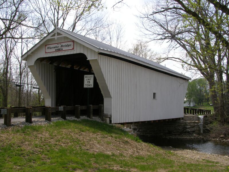
 Warnke Covered Bridge, West Sonora, Ohio
- Dixon Township
- Gasper Township
- Gratis Township
- Harrison Township
- Israel Township
- Jackson Township
- Jefferson Township
- Lanier Township
- Monroe Township
- Somers Township
- Twin Township
- Washington Township
Demographics
As of the census[4] of 2000, there were 848,153 people, 338,979 households, and 226,182 families residing within the MSA. The racial makeup of the MSA was 82.11% White, 14.44% African American, 0.23% Native American, 1.32% Asian, 0.03% Pacific Islander, 0.42% from other races, and 1.43% from two or more races. Hispanic or Latino of any race were 1.16% of the population.
The median income for a household in the MSA was $43,754, and the median income for a family was $51,685. Males had a median income of $38,430 versus $26,205 for females. The per capita income for the MSA was $21,228.
From the 2000 Census to the 2010 Census, the Dayton region has seen a shift in population from its urban core to more out-lying affluent suburbs. This is evidenced by a 10% growth in population in Englewood, a %19 population growth in Beavercreek, and a 40% population growth in Springboro. Smaller growths in the 2010 census in the Dayton area included Miamisburg, Centerville, Vandalia, and Fairborn. Many of Dayton's suburbs that saw declines in populations fared well from 2000 to 2010. Dayton's largest suburb, Kettering for example, only saw a 2.3% decline during the ten-year period and Huber Heights, Dayton's third largest suburb, saw a 0.3% decline in population.
Colleges and universities
The Greater Dayton region is home to a number of higher education facilities, including:
- Air Force Institute of Technology (Wright-Patterson AFB)
- Antioch College (Yellow Springs)
- Cedarville University (Cedarville)
- Central State University (Wilberforce)
- Kettering College of Medical Arts (Kettering)
- Sinclair Community College (Dayton)
- University of Dayton (Dayton)
- Wilberforce University (Wilberforce)
- Wittenberg University (Springfield)
- Wright State University (Fairborn)
Largest employers
Notable largest employers in the Dayton region :[5]
- Wright-Patterson Air Force Base 27,406
- Premier Health Partners 14,335
- Kettering Health Network 9,500
- Miami University 4,438
- Wright State University 3,095
- LexisNexis 3,000
- University of Dayton 2,978
- Honda Manufacturing of America 2,940
- AK Steel Holding 2,500
Transportation
Airports
Greater Dayton is served by international, regional and county airports, including:
- Dahio Trotwood Airport
- Dayton International Airport
- Dayton-Wright Brothers Airport
- Greene County-Lewis A. Jackson Regional Airport
- Moraine Airpark
- Wright-Patterson Air Force Base
Major highways
 Interstate 70
 Interstate 71
 Interstate 75
 Interstate 675
 U.S. Route 35
 U.S. Route 36
 U.S. Route 40
 U.S. Route 42
 U.S. Route 68
 Ohio State Route 4
 Ohio State Route 41
 Ohio State Route 49
 Ohio State Route 202
 Ohio State Route 235
 Ohio State Route 444
 Ohio State Route 725
 Ohio State Route 741
 Ohio State Route 844
Public transit
The Greater Dayton Regional Transit Authority operates a public busing system in Montgomery county. Other transit agencies serve the surrounding counties and provide connections with RTA, including transit authorities in Greene and Miami counties.
Culture
Museums
- Dayton Art Institute (Dayton)
- Boonshoft Museum of Discovery (Dayton)
- America's Packard Museum (Dayton)
- National Museum of the United States Air Force (Riverside)
Theaters
In addition to Benjamin and Marian Schuster Performing Arts Center, the Dayton Region's largest performing arts center, Greater Dayton has a vibrant theater community throughout the region.
- Beavercreek Community Theatre (Beavercreek) [2]
- Benjamin and Marian Schuster Performing Arts Center (Dayton) [3]
- Brookville Community Theater (Brookville) [4]
- Dayton Playhouse (Dayton) [5]
- La Comedia Dinner Theatre (Springboro)
- Loft Theatre (Dayton) [6]
- Progressive Dance Theater (Dayton) [7]
- Town Hall Theatre (Centerville) [8]
- Victoria Theatre (Dayton) [9]
Theatrical companies
- Dayton Ballet [10]
- Dayton Contemporary Dance Company [11]
- Dayton Opera Associates [12]
- Dayton Theatre Guild [13]
- Human Race Theatre Company [14]
- Victoria Theatre Association [15]
See also
- Miami Valley
- Ohio census statistical areas
- List of United States metropolitan statistical areas by population
External links
References
- ^ "American FactFinder2". http://factfinder2.census.gov/faces/nav/jsf/pages/index.xhtml. Retrieved 2010-03-20.
- ^ "American FactFinder2". http://factfinder2.census.gov/faces/nav/jsf/pages/index.xhtml. Retrieved 2010-03-20.
- ^ Ready for `Daytonnati?' It could happen
- ^ "American FactFinder". United States Census Bureau. http://factfinder.census.gov. Retrieved 2008-01-31.
- ^ "Dayton Economy Employers and Employees". June 25, 2009. http://www.daytondailynews.com/business/ncrs-not-top-dog-public-and-non-profits-are-top-employers-151503.html?bigName=&bigPhotog=&bigCap=Take+a+closer+look+at+the+Miami+Valley's+top+employers.&bigDeclCap=&bigCred=&bigUrl=http%3a%2f%2fwww.ohio-share.coxnewsweb.com%2fmultimedia%2fdynamic%2f00512%2ftop_miami_valley_em_512741c.jpg&superSizeImage=y.
- Metropolitan Statistical Areas (MSAs)


Wikimedia Foundation. 2010.