- Miamisburg, Ohio
-
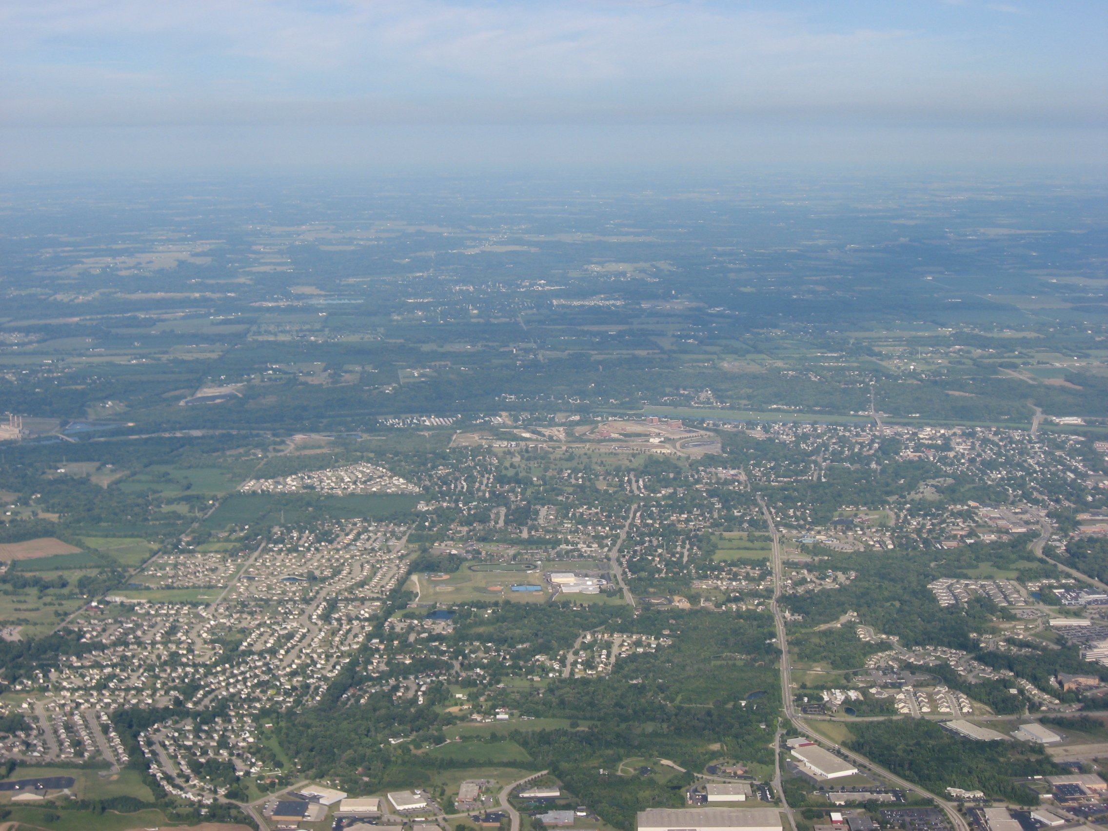
Miamisburg, Ohio — City — Aerial view of Miamisburg
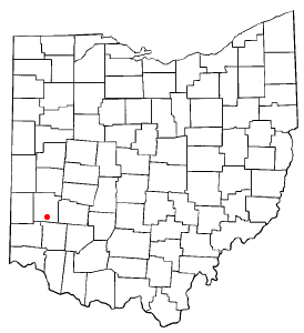
Nickname(s): Hole's Station, The Burg Motto: Ohio's Star City Location of Miamisburg, Ohio Location within Montgomery County, Ohio
Coordinates: 39°38′19″N 84°16′31″W / 39.63861°N 84.27528°WCoordinates: 39°38′19″N 84°16′31″W / 39.63861°N 84.27528°W Country United States State Ohio County Montgomery Founded 1797 Incorporated 1818 Government - Mayor Dick Church, Jr. Area - Total 11.4 sq mi (29.5 km2) - Land 11.2 sq mi (29.0 km2) - Water 0.2 sq mi (0.5 km2) Elevation 699 ft (213 m) Population (2010) - Total 20,181 - Density 1,741.6/sq mi (672.5/km2) Time zone EST (UTC-5) - Summer (DST) EDT (UTC-4) ZIP codes 45342-45343 Area code(s) 937 FIPS code 39-49434[1] GNIS feature ID 1085476[2] Website http://www.ci.miamisburg.oh.us/ Miamisburg (mye-AM-eez-burg) is a city in Montgomery County, Ohio, United States. The population was 20,181 at the 2010 census.[3] It is part of the Dayton Metropolitan Statistical Area. Miamisburg is known for its large industry (mainly for its nuclear operations during World War II) and retail factors (such as the Dayton Mall), which is actually located in Miami twp., but is mainly known for being the home to the Miamisburg Mound. Many large corporations are located in Miamisburg such as LexisNexis, which is in Miami Twp., Dayco, X-spine, Isotec, Teradata, and Motoman (Miami Twp.) Miamisburg borders Miami Township, Springboro, and West Carrollton. The sister city of Miamisburg is Owen Sound, Ontario.[4][5]
Contents
History
European-Americans started calling their first community as "Hole's Station" since about 1797, when Zechariah Hole settled there with his family from Virginia and built a stockade on the west bank of the Miami River opposite the mouth of Bear Creek. The stockade attracted squatters, surveying parties, and other settlers who had taken grants to live in the local cabins until they could build their own; hence the little community became known as "Hole's Station". Settlers came west primarily from Pennsylvania. By 1822 the unincorporated community had become a village; it achieved city status in the 1920s.
By 1827, the Miami and Erie Canal was under construction through the community, which improved transportation of people and goods through the region. The formal opening took place in January 1829, when the Governor Brown was the first packet boat to go through the settlement. Also that year the first boats from Cincinnati had arrived and passed through Miamisburg to get to Dayton. By 1834 the canal had been extended to Piqua, and many businesses along the river grew. The 1840s and the 1850s were brought the best of times to the canals.
George Kinder, a local resident, shipped bags of food to Ireland during its Great Famine; these also contained his address, with ads saying that he was hiring immigrant workers. Some Irish immigrants did come to Miamisburg and surrounding cities in search of work. But by the early 20th century, the canal was abandoned. Later highways carried most of the local traffic.
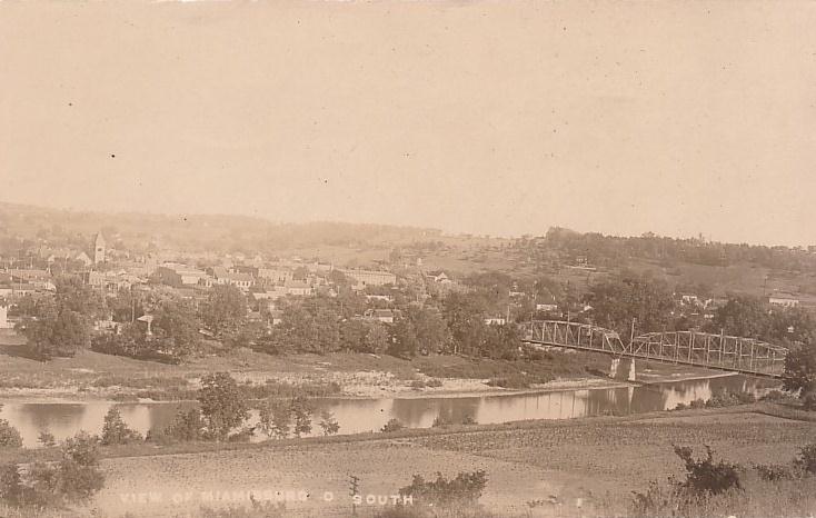
 1910 Photo of Downtown Miamisburg
Miamisburg was the site of one of the first post-war U.S Atomic Energy Commission (AEC) facilities, beginning in 1947. The Dayton area had supported numerous secret operations for the War Department during World War II. As the war ended, the majority of these operations were moved to the Miamisburg Mound Laboratory, which was operated by the Monsanto Chemical Company. The Mound Labs were to monitor all aspects of the US nuclear defense stockpile.
The Mound Plant, built in 1947, was situated on a 306–acre site in the city 10 miles (16 km) south of Dayton. The workers, who numbered more than 2,000 at the height of the production, made plutonium detonators for nuclear weapons. Their work was very classified. The plant had a small army of security guards and was ringed by chain-link fencing and razor wire. When the Cold War ended, the plant discontinued the detonator work, but it continued the make a generators for space probes.
In May 1993 U.S Department of Energy decided to end the all productions at the Mound. This move affected 2,100 employees in the local area. By 1996 cleanup of radioactive and hazardous waste was the main activity at the Plant. The Mound Development Corporation spearheaded the creation of the Mound Advanced Technology Center in the redevelopment of the plant, with the Montgomery County Regional Dispatch Center joining 14 other tenants in March 2009. In December 2010, the Dayton Police Department became the 17th law enforcement agency, along with 11 fire departments, to be dispatched from the regional center.
On September 10, 1978, 15 cars of a Conrail freight train derailed as the result of a hotbox, caused by uneven distribution of steel ingots in a gondola loaded at Buffalo, New York by Republic Steel. They demolished a house at the Pearl Street crossing and killed its three occupants. The deaths were ruled homicides by the Montgomery County Coroner.
Eight years later, on July 8, 1986, another train derailed on the CSX line on the west bank of the Great Miami River, igniting phosphorus contained in some of the tanker cars. This led to the evacuation of approximately 20,000 people across southern Montgomery County, the largest evacuation in Ohio history. The resulting thick white cloud engulfed communities as far north as Yellow Springs, Pitchin, and South Vienna. Rolling in like a massive desert dust storm across the horizon, the chemical cloud hugged the ground and blotted out the sun for several minutes before dissipating. More than $1 billion in lawsuits resulted.
A nitric oxide distillation column at a local chemical plant known as Isotec exploded on September 21, 2003, causing school and other events to be cancelled. Isotec is a division of Sigma-Aldrich.
World headquarters of JatroDiesel is located in Miamisburg. JatroDiesel manufactures biodiesel equipment and produces biodiesel, a sustainable alternative energy fuel to diesel. The headquarters of National City Mortgage Corporation, a division of National City Corp. World headquarters of LexisNexis, were located in Miamisburg. In 2007 the headquarters it moved to New York City, but the operations remain in Ohio.
In the year 2018, a time vault is set to be opened to celebrate the city's 200th birthday.
Miamisburg Mound
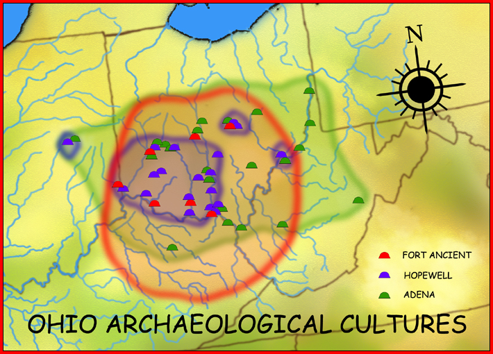
 Miamisburg Mound, the largest conical mound in Ohio, is attributed to the Adena Culture, 1000-200 BCE.
Miamisburg is the location of a prehistoric Indian burial mound (tumulus), believed to have been built by the Adena Culture, about 1000 to 200 BCE. Once serving as an ancient burial site, the mound has become perhaps the most recognizable historic landmark in Miamisburg. It is the largest conical burial mound in Ohio, originally nearly 70 feet tall (the height of a seven-story building) and 877 feet in circumference; it remains virtually intact from its construction perhaps 2500 years ago.
Located in a city park at 900 Mound Avenue, it has been designated an Ohio historical site. It is a popular attraction and picnic destination for area families. Visitors can climb to the top of the Mound, via concrete steps built into its side. It is located at coordinates 39°37′39″N 84°16′51″W / 39.627553°N 84.280889°WCoordinates: 39°37′39″N 84°16′51″W / 39.627553°N 84.280889°W.
Climate
Miamisburg and its surrounding region’s climate are dominated by a humid continental climate, characterized by hot, muggy summers and cold, dry winters. Miamisburg is prone to severe weather because of its location in the Midwestern section of the United States. Tornadoes are possible from spring to fall. Floods, blizzards, and severe thunderstorms can also occur.
Miamisburg has suffered some natural disasters. In 1869, a tornado struck the northwest part of town on June, 9th, allegedly destroying roofs and chimneys, and uprooting trees. It also destroyed Linden Avenue Bridge. Blizzards struck the town in 1978, 2004, and 2008.
In 1913 the Great Dayton Flood destroyed most of the city. The slightest precipitation has a direct positive correlation to the flooding of locations such as Rice Field, which is on the banks of the Great Miami River.
-
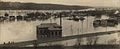
View of Miamisburg under water, 1913
-
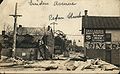
View of rubble on Linden Avenue after 1913 flood
-
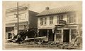
View of aftermath of 1913 flood
City architecture
Due to the growth of the city in the nineteenth century, many houses in the city are mainly Victorian-style homes. They are concentrated in “Old Miamisburg” or the Downtown and river Area. Other architectural styles include Queen Ann, Italianate, and Second Empire-styled buildings. Much of Miami Township has residential housing of single-family homes, which were built during the expanded suburban development of the 1970s through 1990s. Newer models have been built in the 21st century. Residents have sought higher-priced luxury homes, evidenced in new developments such as Pipestone, Crains Run, Heincke Woods, and Bear Creek.
See Also Template:Neighborhoods of Miamisburg, OH
Transportation
Miamisburg is generally known as a walkable community where shopping, dining, recreational, and religious destinations are easily accessible by foot. Miamisburg is also part of the Greater Dayton Regional Transit Authority, which has many bus routes located throughout the city. The key destination with the RTA is the Dayton Mall.
The city has no airport, but travelers can use airports in nearby cities, such as Springboro. The main airport for the city is the James M. Cox Dayton International Airport, located in Vandalia, Ohio. Small regional public airports include:
- Moraine Air Park, located in Moraine, Ohio
- Dayton-Wright Brothers Airport, located in Springboro, Ohio
- Dayton-New Lebanon Airport, located in between Dayton, Ohio and New Lebanon, Ohio
Taxi companies provide service in the area.CSX and Norfolk Southern provide freight railway services. CSX passes near Miamisburg on the west side of the Miami River and Norfolk Southern's line runs through downtown.
Education
Miamisburg makes up Miamisburg City School. There are ten schools that make up the district.
- Anna K. Wantz Middle School (1927-ceased to be used as a school 2011)
- Bauer Elementary (1967)
- Bear Elementary (1956)
- Jane Chance Elementary (2010)
- Kercher Street Elementary (1899 - Demolished 1963)
- Kinder Elementary (1906)
- Maddux-Lang Primary (2008)
- Mark Twain Elementary (1950)
- Maud Bell High School (1922 - formerly 9th Grade - Demolished 1982)
- Medlar View Elementary (1999)
- Miamisburg High School (1972)
- Miamisburg Middle School (2011)
- Mound Elementary (1955)
- Neff Elementary (1962 - formerly the old High School - Demolished 2011)
Miamisburg is ranked third in the Dayton Area for the best academic rate scores. Miamisburg has won the “Excellent District Award” in 2002, 2003, 2004, 2005, and again in 2006. Miamisburg High School was recognized as a National Blue Ribbon School of Excellence in 1997. Both Wantz Middle School and Kinder Elementary were awarded Blue Ribbon Awards in the early 21st century. Recently, in 2006, Kinder Elementary celebrated it's 100 year anniversary. Also, Kinder adopted a mascot the kangaroo.After several failed attempts, the Miamisburg community passed a $78.5 million bond issue on March 4, 2008. The issue will raise about $23 million for an addition and renovation project at Miamisburg High School and $31 million for a new middle school to serve 1500 students in grades 6-8. The bond issue also include $11 million for a seventh elementary school for 550 students, $11 million for an addition/renovation project at historic Kinder Elementary School , and $4 million for security enhancements to all other buildings in the district. Construction was complete in 2010 for the new Dr. Jane Chance Elementary School on Wood Road. The new Miamisburg Middle School on Miamisburg-Springboro Road has opened just before the start of the 2011-2012 school year. Additions and renovations at Miamisburg High School and Kinder Elementary will be complete in August 2012.
Culture and recreation
Miamisburg has a varied culture dating back to the 18th century. Miamisburg is home to a variety of popular buildings located throughout the city. North of Miamisburg in Dayton are home to more well known buildings such as the Victoria Theatre, Benjamin and Marian Schuster Performing Arts Center, Fifth Third Field, and the Fraze Pavilion in Kettering; and north of Dayton sits Hara Arena.
Popular Miamisburg attractions
See Also Downtown Miamisburg
- Baum Opera House (on S. First Street near Central Ave.)
- Community Park and Skatepark (on S. 1st St.)
- Cox Arboretum (on St. Rt. 741)
- Historic Downtown Miamisburg
- Gebhart Tavern Museum (on Old Main Street)
- Library and Library Park (on 5th St. at Central Ave.)
- Market Square (on Main St. And Central Ave.)
- Miamisburg Civic Center
- Miamisburg Indian Mound and Mound Park (on Mound Ave. east of 6th St.)
- Sycamore Trails Aquatic Center (STAC) (Heincke Rd. and Maue Rd.)
- Sycamore Trails Park (off St. Rt. 725, on the corner of Heincke Rd.)
Annual events
- Miamisburg Starving Artists (Open air arts and craft show)
- Christmas Starving Artists (November indoor arts and craft show)
- Spring Fling (Annual Carnival)
- Miamisburg Turkey Trot (Thanksgiving Day 8K Run/Walk)
- Cruise The Burg (auto show)
- Tour D'Burg (bicycle racing)
- Thunderburg Motorcycle Show
- Boo in the Burg (Halloween gathering)
Media
Miamisburg is in the circulation area of the Dayton Daily News, and it publishes the Miamisburg/West Carrollton News. The city has a local radio station.
FM Format
- WFCJ 93.7 – Christian (WFJC Inspiration...)
Geography
Miamisburg is located at 39°38′19″N 84°16′31″W / 39.63861°N 84.27528°W (39.638525, -84.275280)[6].
According to the United States Census Bureau, the city has a total area of 11.4 square miles (30 km2), of which, 11.2 square miles (29 km2) of it is land and 0.2 square miles (0.52 km2) of it (1.67%) is water.
Demographics
Historical populations Census Pop. %± 1870 1,425 — 1880 1,936 35.9% 1890 2,952 52.5% 1900 3,941 33.5% 1910 4,271 8.4% 1920 4,383 2.6% 1930 5,518 25.9% 1940 5,544 0.5% 1950 6,329 14.2% 1960 9,803 54.9% 1970 14,797 50.9% 1980 15,327 3.6% 1990 17,834 16.4% 2000 19,489 9.3% 2010 20,181 3.6% As of the census[1] of 2000, there were 19,489 people, 7,449 households, and 5,393 families residing in the city. The population density was 1,741.6 people per square mile (672.5/km²). There were 7,905 housing units at an average density of 706.4 per square mile (272.8/km²). The racial makeup of the city was 95% White, 1.6% African American, 0.13% Native American, 0.73% Asian, 0.04% Pacific Islander, 0.3% from other races, and 1.29% from two or more races. Hispanic or Latino of any race were 0.85% of the population.
There were 7,449 households out of which 35.0% had children under the age of 18 living with them, 58.2% were married couples living together, 10.6% had a female householder with no husband present, and 27.6% were non-families. 23.3% of all households were made up of individuals and 9.6% had someone living alone who was 65 years of age or older. The average household size was 2.53 and the average family size was 3.00.
In the city the population was spread out with 25.9% under the age of 18, 7.1% from 18 to 24, 29.3% from 25 to 44, 22.4% from 45 to 64, and 15.3% who were 65 years of age or older. The median age was 38 years. For every 100 females there were 92.2 males. For every 100 females age 18 and over, there were 87.7 males.
The median income for a household in the city was $48,316, and the median income for a family was $56,996. Males had a median income of $41,918 versus $28,045 for females. The per capita income for the city was $22,504. About 4.6% of families and 6.1% of the population were below the poverty line, including 7.3% of those under age 18 and 7.7% of those age 65 or over.
Sister cities
 – Owen Sound, Ontario
Notable natives
- The McGuire Sisters - 20th century female trio
- David Bruton - American football player
References
- ^ a b "American FactFinder". United States Census Bureau. http://factfinder.census.gov. Retrieved 2008-01-31.
- ^ "US Board on Geographic Names". United States Geological Survey. 2007-10-25. http://geonames.usgs.gov. Retrieved 2008-01-31.
- ^ "American FactFinder2". http://factfinder2.census.gov/faces/nav/jsf/pages/index.xhtml. Retrieved 2010-03-20.
- ^ "Owen Sound Ontario Canada links page". City of Owen Sound. http://www.works.city.owen-sound.on.ca/links.htm. Retrieved 2006-12-08.
- ^ "The city of Miamisburg, facts and figures". http://www.ci.miamisburg.oh.us/index.php?option=content&task=view&id=80&Itemid=110. Retrieved 2006-12-08.
- ^ "US Gazetteer files: 2010, 2000, and 1990". United States Census Bureau. 2011-02-12. http://www.census.gov/geo/www/gazetteer/gazette.html. Retrieved 2011-04-23.
External links
- City of Miamisburg
- Miamisburg Mound Park
- Events and news in Miamisburg
- Handy Map of Downtown Miamisburg
- The history behind the saving of the Kercher Cabin
- Web Guide to Miamisburg
- Miamisburg City Schools
- Dayton Metro Library, Miamisburg Branch
- Miamisburg Historical Society
- Daniel Gebhart Tavern Museum
- Jacob Kercher Pioneer Home
- Miamisburg Ohio Pictures & Videos
- Miamisburg Library Park
- Miamisburg Historical Society
- South Metro Regional Chamber of Commerce
- Miamisburg travel guide from Wikitravel
Municipalities and communities of Montgomery County, Ohio County seat: Dayton Cities Brookville | Centerville‡ | Clayton | Dayton | Englewood | Germantown | Huber Heights‡ | Kettering‡ | Miamisburg | Moraine | Oakwood | Riverside | Springboro‡ | Trotwood | Union‡ | Vandalia | West Carrollton

Villages Carlisle‡ | Farmersville | New Lebanon | Phillipsburg | Verona‡
Townships CDPs Unincorporated
communitiesGhost town Footnotes ‡This populated place also has portions in an adjacent county or counties
List of Adena culture sites · Woodland period · Mound builder (people) · List of archaeological periods (North America) Ohio Sites Adena Mound · Austin Brown Mound · Arledge Mounds I and II · Beam Farm · Clemmons Mound · Conrad Mound Archeological Site · Coon Hunters Mound · George Deffenbaugh Mound · Enon Mound · Fortner Mounds · Great Mound · Highbanks Metropolitan Park Mounds I and II · Hillside Haven Mound · Hodgen's Cemetery Mound · Horn Mound · Hurley Mound · Jackson Mound · Karshner Mound · Kinzer Mound · Luthor List Mound · Miamisburg Mound · Odd Fellows' Cemetery Mound · Old Maid's Orchard Mound · Orators Mound · Carl Potter Mound · Reeves Mound · D.S. Rose Mound · Ross Trails Adena Circle · Short Woods Park Mound · Snead Mound · Spruce Run Earthworks · David Stitt Mound · Story Mound (Cincinnati) · Story Mound (Chillicothe) · Wolf Plains Group · Zaleski Mound Group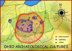
Kentucky Sites West Virginia Sites Indiana Sites Related topics · Ancient Monuments of the Mississippi Valley · burial mound · Eastern Agricultural Complex · Hopewell tradition Categories:- Adena culture
- Cities in Ohio
- Populated places in Montgomery County, Ohio
- Miamisburg, Ohio
- Greater Dayton
- Populated places established in 1797
-


Wikimedia Foundation. 2010.