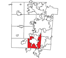
- Miami Township, Montgomery County, Ohio
-
Miami Township, Montgomery County, Ohio — Township — Location within Montgomery County Coordinates: 39°38′4″N 84°15′21″W / 39.63444°N 84.25583°WCoordinates: 39°38′4″N 84°15′21″W / 39.63444°N 84.25583°W Country United States State Ohio County Montgomery Area – Total 34.4 sq mi (89.1 km2) – Land 34.0 sq mi (88.2 km2) – Water 0.4 sq mi (1.0 km2) Elevation[1] 919 ft (280 m) Population (2000) – Total 45,593 – Density 1,339.4/sq mi (517.1/km2) Time zone Eastern (EST) (UTC-5) – Summer (DST) EDT (UTC-4) FIPS code 39-49392[2] GNIS feature ID 1086675[1] Miami Township is one of the nine townships of Montgomery County, Ohio, United States. The 2000 census found 45,593 people in the township, 25,706 of whom lived in the unincorporated portions of the township.[3]
Contents
Geography
Located in the southern part of the county, it borders the following townships and cities:
- Moraine - north
- Kettering - northeast
- Washington Township - east
- Clearcreek Township, Warren County - southeast
- Franklin Township, Warren County - south
- German Township - west
- Jefferson Township - northwest
Several cities are located in Miami Township:
- Part of Carlisle, in the southwest
- Miamisburg, in the center
- Part of Springboro, in the southeast
- Part of West Carrollton, in the north
The township is highly urbanized in its eastern half, nearest to Miamisburg and Kettering. Ohio law prohibits townships from collecting income taxes from residents; thus, the township has seen higher growth than incorporated towns nearby.[citation needed]
Name and history
Statewide, other Miami Townships are located in Clermont, Greene, Hamilton, and Logan Counties.
Economy
Miami Township is home to the American offices of Lexis-Nexis information systems, a regional office of MetLife insurance and world headquarters of Teradata. It is also home to the area's oldest major shopping area, the Dayton Mall, and it has Southview Hospital, a member of the Kettering Medical Center Network, a Seventh-day Adventist facility.
Government
The township is governed by a three-member board of trustees, who are elected in November of odd-numbered years to a four-year term beginning on the following January 1. Two are elected in the year after the presidential election and one is elected in the year before it. There is also an elected township fiscal officer,[4] who serves a four-year term beginning on April 1 of the year after the election, which is held in November of the year before the presidential election. Vacancies in the fiscal officership or on the board of trustees are filled by the remaining trustees.
Property taxes are used to fund police and fire departments.
Transportation
It lies at a major access point to both Interstate 75 and Interstate 675.
Education
Children from Miami Township attend the schools of Kettering, Miamisburg, or West Carrollton.
References
- ^ a b "US Board on Geographic Names". United States Geological Survey. 2007-10-25. http://geonames.usgs.gov. Retrieved 2008-01-31.
- ^ "American FactFinder". United States Census Bureau. http://factfinder.census.gov. Retrieved 2008-01-31.
- ^ Montgomery County, Ohio — Population by Places Estimates Ohio State University, 2007. Accessed 15 May 2007.
- ^ §503.24, §505.01, and §507.01 of the Ohio Revised Code. Accessed 4/30/2009.
External links
Municipalities and communities of Montgomery County, Ohio Cities Brookville | Centerville‡ | Clayton | Dayton | Englewood | Germantown | Huber Heights‡ | Kettering‡ | Miamisburg | Moraine | Oakwood | Riverside | Springboro‡ | Trotwood | Union‡ | Vandalia | West Carrollton
Villages Carlisle‡ | Farmersville | New Lebanon | Phillipsburg | Verona‡
Townships CDPs Unincorporated
communitiesGhost town Footnotes ‡This populated place also has portions in an adjacent county or counties
Categories:- Townships in Montgomery County, Ohio
- Greater Dayton
Wikimedia Foundation. 2010.


