- Ohio State Route 844
-
State Route 844 
Route information Maintained by ODOT Length: 2.32 mi[1] (3.73 km) Major junctions South end:  I-675 in Beavercreek
 SR 444 in Fairborn
North end: Wright-Patterson Air Force Base near Fairborn Location Counties: Greene Highway system Ohio highways
Interstates • U.S. Routes • State Routes←  SR 835
SR 850  →
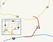
→State Route 844 (SR 844) is a north–south controlled-access state highway in the southwestern portion of the U.S. state of Ohio. Located near Dayton, its southern terminus is at a partial interchange with I-675 in Beavercreek, and its northern terminus is just north of its interchange with SR 444 in Fairborn, at Gate 15A of Wright-Patterson Air Force Base.
SR 844 also provides access to Wright State University, through its partial interchange with Colonel Glenn Highway and its full interchange with University Boulevard.
SR 844 is designated "McClernon Memorial Skyway",[2] after the late Brigadier General Glen J. McClernon.[3] McClernon had been base commander[4][5] during the time the university was being established[6] — partially on land deeded to it by the Air Force base[7] — and also had been a two-term mayor of Fairborn.[8]
Contents
History
SR 844 was originally SR 444A, which opened by 1989[9]. After a public comment period in 1994[10], ODOT changed the number to "844" by 1995[9].
Future
There are plans to add a ramp from northbound SR 844 to northbound SR 444, and to add a ramp from northbound SR 444 to southbound SR 844.[1] As of this writing, the status and funding for this project are unknown.
References
- ^ a b Ohio Department of Transportation. "Technical Services Straight Line Diagrams". http://www.odotonline.org/techservapps/SLD/default.htm. Retrieved April 30, 2010.
- ^ Ohio Revised Code. "5533.43 McClernon-Skyway memorial drive". http://codes.ohio.gov/orc/5533.43. Retrieved November 7, 2011.
- ^ "Glen McClernon (1918 - 1984) Genealogy - Fairborn, Greene County, Ohio". http://www.ancientfaces.com/research/person/28463599/glen-mcclernon-profile-and-genealogy. Retrieved November 7, 2011.
- ^ "Biographies: Brigadier General Glen J. McClernon". United States Air Force. April 1, 1968. http://www.af.mil/information/bios/bio.asp?bioID=6356. Retrieved November 7, 2011.
- ^ "Factsheets: 88 Air Base Wing (AFMC)". Air Force Historical Research Agency. April 27, 2010. http://www.afhra.af.mil/factsheets/factsheet.asp?id=9831. Retrieved November 7, 2011.
- ^ "Book I - The Founding" (pdf). Wright State University. http://core.libraries.wright.edu/bitstream/handle/2374.WSU/591/pages%20001-026.pdf. Retrieved November 7, 2011.
- ^ "Wright Brothers Collection: History - Special Collections & Archives - Historical Background". Wright State University. http://www.libraries.wright.edu/special/wright_brothers/wb_collection/history.html. Retrieved November 7, 2011.
- ^ "Glen McClernon obituary - Google News Archive Search". The (Toledo) Blade. August 20, 1984. http://news.google.com/newspapers?nid=1350&dat=19840820&id=X20xAAAAIBAJ&sjid=xAIEAAAAIBAJ&pg=5247,3363718. Retrieved November 7, 2011.
- ^ a b Ohio Department of Transportation Official maps
- ^ "Ohio proposes renaming road". Dayton Daily News. 1994-06-15. http://infoweb.newsbank.com/iw-search/we/InfoWeb?p_action=doc&p_topdoc=1&p_docnum=1&p_sort=YMD_date:D&p_product=NewsBank&p_text_direct-0=document_id=(%200F51AB27DA000B3E%20)&p_docid=0F51AB27DA000B3E&p_theme=aggregated5&p_queryname=0F51AB27DA000B3E&f_openurl=yes&p_nbid=F66K5AUUMTIxMTA1MjYxOC4zOTQ3NjM6MToxMjo2Ni4yMTMuOTguOTg&&p_multi=DDNB. Retrieved 2008-05-17.
External links
Categories:- State highways in Ohio
- Wright-Patterson Air Force Base
- Freeways in the United States
Wikimedia Foundation. 2010.

