- New Jasper Township, Greene County, Ohio
-
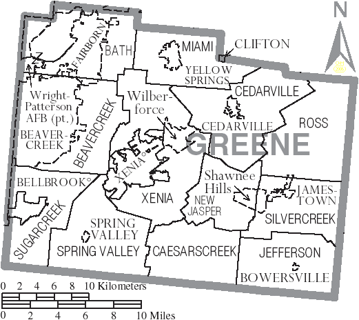
New Jasper Township, Ohio — Township — Municipalities and townships of Greene County.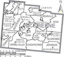
Coordinates: 39°39′21″N 83°48′50″W / 39.65583°N 83.81389°WCoordinates: 39°39′21″N 83°48′50″W / 39.65583°N 83.81389°W Country United States State Ohio County Greene Area – Total 21.4 sq mi (55.4 km2) – Land 21.3 sq mi (55.1 km2) – Water 0.1 sq mi (0.4 km2) Elevation[1] 1,020 ft (311 m) Population (2000) – Total 2,538 – Density 119.4/sq mi (46.1/km2) Time zone Eastern (EST) (UTC-5) – Summer (DST) EDT (UTC-4) FIPS code 39-54810[2] GNIS feature ID 1086170[1] New Jasper Township is one of the twelve townships of Greene County, Ohio, United States. The 2000 census found 2,538 people in the township.[3]
Contents
Geography
Located in the east central part of the county, it borders the following townships:
- Cedarville Township - north
- Ross Township - northeast
- Silvercreek Township - southeast
- Caesarscreek Township - south
- Xenia Township - west
No municipalities are located in New Jasper Township, although part of the census-designated place of Shawnee Hills is located in the township's east.
Name and history
It is the only New Jasper Township statewide.[4]
Government
The township is governed by a three-member board of trustees, who are elected in November of odd-numbered years to a four-year term beginning on the following January 1. Two are elected in the year after the presidential election and one is elected in the year before it. There is also an elected township fiscal officer,[5] who serves a four-year term beginning on April 1 of the year after the election, which is held in November of the year before the presidential election. Vacancies in the fiscal officership or on the board of trustees are filled by the remaining trustees.
Notable natives
- Darrell McCall, country music singer
References
- ^ a b "US Board on Geographic Names". United States Geological Survey. 2007-10-25. http://geonames.usgs.gov. Retrieved 2008-01-31.
- ^ "American FactFinder". United States Census Bureau. http://factfinder.census.gov. Retrieved 2008-01-31.
- ^ Greene County, Ohio — Population by Places Estimates Ohio State University, 2007. Accessed 15 May 2007.
- ^ "Detailed map of Ohio" (PDF). United States Census Bureau. 2000. http://www2.census.gov/geo/maps/general_ref/cousub_outline/cen2k_pgsz/oh_cosub.pdf. Retrieved 2007-02-16.
- ^ §503.24, §505.01, and §507.01 of the Ohio Revised Code. Accessed 4/30/2009.
External links
Municipalities and communities of Greene County, Ohio Cities Beavercreek | Bellbrook | Centerville‡ | Fairborn | Huber Heights‡ | Kettering‡ | Xenia

Villages Bowersville | Cedarville | Clifton‡ | Jamestown | Spring Valley | Yellow Springs
Townships Bath | Beavercreek | Caesarscreek | Cedarville | Jefferson | Miami | New Jasper | Ross | Silvercreek | Spring Valley | Sugarcreek | Xenia
CDPs Unincorporated
communitiesByron | Goes Station
Footnotes ‡This populated place also has portions in an adjacent county or counties
Categories:- Townships in Greene County, Ohio
- Greater Dayton

Wikimedia Foundation. 2010.