Mobile metropolitan area

Mobile metropolitan area
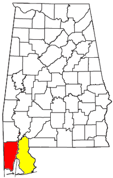
Location of the Mobile-Daphne-Fairhope CSA and its components:
  Mobile Metropolitan Statistical Area
  Daphne-Fairhope-Foley Micropolitan Statistical Area

Metropolitan Mobile has a population of 412,992[1] within Mobile County Alabama in the southwestern tip of Alabama. The Mobile metropolitan area is the third-largest metropolitan area in the state of Alabama. The Mobile–DaphneFairhope combined statistical area also includes the micro but separate Baldwin County metro, with a population of 182,265. The total Mobile–Daphne–Fairhope CSA is 595,257.

Year Mobile MSA Daphne-Fairhope μSA Total
2000 Census 399,843 140,415 540,258
2008 Estimate 406,309 174,349 580,648
2009 Estimate 411,721 179,878 591,599
2010 Census 412,992 182,265 595,257
2011 Estimate 415,704 187,173 602,877

Contents

Mobile County Communities

Places with 10,000 to 35,000 inhabitants

Places with 1,000 to 10,000 inhabitants

Places with less than 1,000 inhabitants

Unincorporated places

Baldwin County Communities

Places with 10,000 to 35,000 inhabitants

Places with 1,000 to 10,000 inhabitants

Unincorporated places

References

  1. ^ http://www.census.gov/popest/metro/metro.html

Coordinates: 30°47′11″N 88°12′50″W / 30.78639°N 88.21389°W / 30.78639; -88.21389


Wikimedia Foundation. 2010.

Игры ⚽ Поможем написать курсовую

Look at other dictionaries:

  • Montgomery Metropolitan Area — Montgomery MSA Common name: Montgomery Metropolitan Area Largest city Montgomery …   Wikipedia

  • Decatur Metropolitan Area — Statistical Area Decatur Metropolitan Statistical Area is shaded in yellow. Decatur MSA is part of the Huntsville Decatur CSA (shown in yellow and red) …   Wikipedia

  • Atlanta metropolitan area — Metro Atlanta redirects here. For the transit agency, see Metropolitan Atlanta Rapid Transit Authority. Metro Atlanta Atlanta Sandy Springs Marietta, Georgia MSA   CSA   …   Wikipedia

  • Mobile, Alabama — Mobile   City   From top: Pincus Building, Old City Hall and Southern Market, Fort Condé, Barton Academy, Cathedral Basilica of the Immaculate Co …   Wikipedia

  • Auburn, Alabama metropolitan area — Coordinates: 32°37′54.69″N 85°28′54.74″W / 32.6318583°N 85.4818722°W / 32.6318583; 85.4818722 …   Wikipedia

  • Dothan, Alabama metropolitan area — Location of the Dothan Enterprise Ozark CSA, with the Dothan Metropolitan Statistical Area highlighted in red The Dothan Metropolitan Statistical Area, as defined by the United States Census Bureau, is an area consisting of three counties in… …   Wikipedia

  • South Florida metropolitan area — South Florida redirects here. For the university in Tampa, see University of South Florida. For that school s athletic program, see South Florida Bulls. Miami–Fort Lauderdale–Pompano Beach Common name: South Florida Larg …   Wikipedia

  • Columbus, Georgia metropolitan area — For the Columbus–Auburn–Opelika, GA AL Combined Statistical Area, see Greater Columbus, Georgia. The Columbus, Georgia Metropolitan Statistical Area, as defined by the United States Census Bureau, is an area consisting of four counties in Georgia …   Wikipedia

  • Street grid (Denver-Aurora Metropolitan Area) — A uniform street naming system is used in the Denver Aurora Metropolitan Area, covering Denver, Adams, Arapahoe, Jefferson, and parts of Broomfield and northern Douglas County. However, there are significant areas within the metro area that do… …   Wikipedia

  • Mobile County, Alabama — Coordinates: 30°47′11″N 88°12′50″W / 30.78639°N 88.21389°W / 30.78639; 88.21389 …   Wikipedia

Share the article and excerpts

Direct link
Do a right-click on the link above
and select “Copy Link”