- Columbus, Georgia metropolitan area
-
For the Columbus–Auburn–Opelika, GA-AL Combined Statistical Area, see Greater Columbus, Georgia.
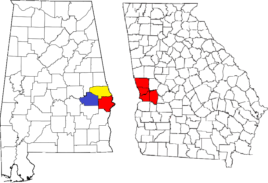
The Columbus, Georgia Metropolitan Statistical Area, as defined by the United States Census Bureau, is an area consisting of four counties in Georgia and one county in Alabama, anchored by the city of Columbus. As of the 2000 census, the MSA had a population of 281,768 (though a July 1, 2009 estimate placed the population at 292,795).[1]
Contents
Counties
- Chattahoochee County, Georgia
- Harris County, Georgia
- Marion County, Georgia
- Muscogee County, Georgia
- Russell County, Alabama
Communities
Places with more than 180,000 inhabitants
- Columbus, Georgia (Principal city)
Places with 10,000 to 30,000 inhabitants
- Cusseta-Chattahoochee, Georgia
- Fort Benning South, Georgia (census-designated place)
- Phenix City, Alabama (partial)
Places with 1,000 to 10,000 inhabitants
- Buena Vista, Georgia
- Ladonia, Alabama (census-designated place)
- Pine Mountain, Georgia (partial)
- West Point, Georgia (partial)
Places with less than 1,000 inhabitants
Unincorporated places
Demographics
As of the census[2] of 2000, there were 281,768 people, 103,982 households, and 72,632 families residing within the MSA. The racial makeup of the MSA was 54.56% White, 40.21% African American, 0.40% Native American, 1.22% Asian, 0.14% Pacific Islander, 1.01% from other races, and 1.74% from two or more races. Hispanic or Latino of any race were 4.02% of the population.
The median income for a household in the MSA was $35,262, and the median income for a family was $40,065. Males had a median income of $29,196 versus $22,834 for females. The per capita income for the MSA was $16,410.
Combined Statistical Area
Main article: Greater Columbus, GeorgiaSee also
References
- ^ "Table 1. Annual Estimates of the Population of Metropolitan and Micropolitan Statistical Areas: April 1, 2000 to July 1, 2009 (CBSA-EST2009-01)" (CSV). 2009 Population Estimates. United States Census Bureau, Population Division. 2010-03-23. http://www.census.gov/popest/metro/tables/2009/CBSA-EST2009-01.csv. Retrieved 2010-03-24.
- ^ "American FactFinder". United States Census Bureau. http://factfinder.census.gov. Retrieved 2008-01-31.
Greater Columbus, Georgia Central cities/Largest cities  Location of the Columbus, Georgia-Auburn, Alabama CSA and its counties:
 Columbus, Georgia Metropolitan Statistical AreaAuburn, Alabama Metropolitan Statistical AreaTuskegee, Alabama Micropolitan Statistical Area
Cities in Georgia Bibb City · Buena Vista · Cataula · Columbus · Cusseta · Custer Terrace · Fort Benning South · Fortson · Hamilton · Hopewell · Juniper · Midland · Mountain Hill · Mulberry Grove · Pine Mountain · Rehobeth · Ridgeway · Shiloh · Upatoi · Waverly Hall · West Point · WhitesvilleCities in Alabama Beauregard · Bee Hive · Beulah · Creek Stand · Fort Mitchell · Franklin · Glenville · Gold Hill · Holy Trinity · Hurtsboro · Ladonia · Loachapoka · Marvyn · Notasulga · Opelika · Phenix City · Roxana · Salem · Seale · Shorter · Smiths Station · The Bottle · Tuskegee · WaverlyCounties in Georgia Counties in Alabama  State of Alabama
Topics Index · History · Geography · People · Delegations · Government · Governors · Lieutenant Governors · Metropolitan Areas · Visitor Attractions · National Historic Landmarks
Regions Atlantic Coastal Plain · Birmingham District · Black Belt · Central Alabama · Cumberland Plateau · Greater Birmingham · Gulf Coastal Plain · Lower Alabama · Mobile Bay · North Alabama · Northeast Alabama · Northwest Alabama · Piedmont · Ridge and Valley · River Region · South Alabama · Tennessee Valley · Wiregrass Region
Metros Greater Birmingham · Montgomery Metro Area · Mobile Metro Area · Huntsville Metro Area
Larger cities Anniston · Auburn · Birmingham · Decatur · Dothan · Florence · Gadsden · Hoover · Huntsville · Madison · Mobile · Montgomery · Tuscaloosa
Counties Autauga · Baldwin · Barbour · Bibb · Blount · Bullock · Butler · Calhoun · Chambers · Cherokee · Chilton · Choctaw · Clarke · Clay · Cleburne · Coffee · Colbert · Conecuh · Coosa · Covington · Crenshaw · Cullman · Dale · Dallas · DeKalb · Elmore · Escambia · Etowah · Fayette · Franklin · Geneva · Greene · Hale · Henry · Houston · Jackson · Jefferson · Lamar · Lauderdale · Lawrence · Lee · Limestone · Lowndes · Macon · Madison · Marengo · Marion · Marshall · Mobile · Monroe · Montgomery · Morgan · Perry · Pickens · Pike · Randolph · Russell · Shelby · St. Clair · Sumter · Talladega · Tallapoosa · Tuscaloosa · Walker · Washington · Wilcox · Winston
Categories:- Columbus, Georgia metropolitan area
- Auburn metropolitan area
- Geography of Chattahoochee County, Georgia
- Geography of Muscogee County, Georgia
- Geography of Harris County, Georgia
- Geography of Marion County, Georgia
- Geography of Russell County, Alabama
- Geography of Lee County, Alabama
Wikimedia Foundation. 2010.