- Muscogee County, Georgia
-
Muscogee County, Georgia 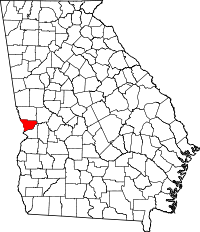
Location in the state of Georgia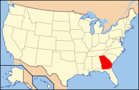
Georgia's location in the U.S.Founded June 9, 1826 Seat Columbus Largest city Columbus Area
- Total
- Land
- Water
221.00 sq mi (572 km²)
216.26 sq mi (560 km²)
4.74 sq mi (12 km²), 2.14%PopulationEst.
- (2009)
- Density
190,414
841/sq mi (325/km²)Time zone Eastern: UTC-5/-4 Website www.muscogeecounty.net Muscogee County is a county located on the central western border of the U.S. state of Georgia. It is part of the Columbus, Georgia-Alabama Metropolitan Statistical Area. As of the 2000 census, the population was 186,291. The 2009 Census Estimate shows a population of 190,414.[1] Its county seat and only city is Columbus,[2] with which it has been a consolidated city-county since the beginning of 1971. It is a part of the Columbus, Georgia-Alabama Metropolitan Area.
The only other city was Bibb City, which disincorporated in December 2000. Fort Benning takes up nearly one quarter of the county. The Chattahoochee River forms its western border with Alabama.
Contents
History
Inhabited for thousands of years by varying cultures of indigenous peoples, this area was territory of the historic Creek people at the time of European encounter.
The land for Lee, Muscogee, Troup, Coweta, and Carroll counties was ceded by a certain eight chiefs among the Creek people in the 1825 Treaty of Indian Springs. The nation declared the land cession illegal, because it did not represent the will of the majority of the people. The United States Senate did not ratify it. The following year, the government negotiated another treaty with the Creek, by which they ceded nearly as much territory.
The counties' boundaries were created by the Georgia General Assembly on June 9, but they were not named until December 14 of 1826.
The county was named for the native Muscogee or Creek people. Parts of the then-large county (which went all the way east to the Flint River) were later taken to create every other neighboring Georgia county, including Harris County to the north in 1827.[3]
Geography
According to the 2000 census, the county has a total area of 221.00 square miles (572.4 km2), of which 216.26 square miles (560.1 km2) (or 97.86%) is land and 4.74 square miles (12.3 km2) (or 2.14%) is water.[4]
Major highways
 Interstate 185
 U.S. Route 27
 U.S. Route 80
 U.S. Route 280
 U.S. Route 431
 Georgia State Route 1
 Georgia State Route 22
 Georgia State Route 85
 Georgia State Route 219
 Georgia State Route 411
 Georgia State Route 520
 Georgia State Route 545
Adjacent counties
- Harris County (north)
- Talbot County (northeast)
- Chattahoochee County (south)
- Russell County, Alabama (southwest)
- Lee County, Alabama (west)
Demographics
Historical populations Census Pop. %± 1840 3,114 — 1850 5,942 90.8% 1860 9,621 61.9% 1870 7,401 −23.1% 1880 10,123 36.8% 1890 17,303 70.9% 1900 17,614 1.8% 1910 20,554 16.7% 1920 31,125 51.4% 1930 43,131 38.6% 1940 53,280 23.5% 1950 79,611 49.4% 1960 116,779 46.7% 1970 155,028 32.8% 1980 169,441 9.3% 1990 178,681 5.5% 2000 186,291 4.3% Est. 2009 190,414 2.2% Population 1840-2000.[5]
Population estimate 2007.[6]As of the census[7] of 2000, there were 186,291 people, 69,819 households, and 47,686 families residing in the county. The population density was 861 people per square mile (333/km²). There were 76,182 housing units at an average density of 352 per square mile (136/km²). The racial makeup of the county was 50.42% White, 43.74% Black or African American, 0.38% Native American, 1.54% Asian, 0.14% Pacific Islander, 1.90% from other races, and 1.87% from two or more races. 4.49% of the population were Hispanic or Latino of any race.
There are 69,819 households out of which 34.60% have children under the age of 18 living with them, 44.70% were married couples living together, 19.60% had a female householder with no husband present, and 31.70% were non-families. 26.70% of all households were made up of individuals and 9.40% had someone living alone who was 65 years of age or older. The average household size was 2.54 and the average family size was 3.08.
In the county the population was spread out with 26.80% under the age of 18, 11.90% from 18 to 24, 29.80% from 25 to 44, 19.70% from 45 to 64, and 11.70% who were 65 years of age or older. The median age was 33 years. For every 100 females there were 94.70 males. For every 100 females age 18 and over, there were 91.60 males.
The median income for a household in the county was $34,798, and the median income for a family was $41,244. Males had a median income of $30,238 versus $24,336 for females. The per capita income for the county was $18,262. 15.70% of the population and 12.80% of families were below the poverty line. Out of the total population, 22.00% of those under the age of 18 and 12.10% of those 65 and older were living below the poverty line.
Education
Higher education
Public
- Columbus State University
- Columbus Technical College
- Troy University[9] - main campus in nearby Troy, Alabama
- University of Phoenix[10]
Private
- Beacon University (Seminary)
- Rivertown School of Beauty
- Southeastern Beauty School
- Meadows Junior College
Primary and secondary education
Public schools
Main article: Muscogee County School DistrictColumbus is home to 65 public schools,[11] all operated by the Muscogee County School District.
Private and religion-based schools
- Brookstone School (K-12)
- Calvary Christian School (Christian, K-12)
- Edgewood Christian School (Baptist, K-12)
- Grace Christian School (Christian, K-12)
- Hallie Turner Private School (9-12)
- Kip Christian Academy (Christian, K-8)
- New Bethel Christian Academy (Seventh-day Adventist, K-8)
- Our Lady of Lourdes School (Catholic, K-8)
- Our Redeemer Christian Academy (Christian, K-12)
- Pinehurst Christian School (Baptist, K-8)
- St. Anne‒Pacelli Catholic School (Catholic, K-12)
- St. Luke School (Methodist, K-8)
- Victory Academy (K-8)
- Westminster Christian School (Christian, K-8)
- Wynnbrook Christian School (Baptist, K-12)
Homeschooling
In regards to homeschooling, the Official Code of Georgia Annotated states the following:
Required Subjects: A basic academic educational program that includes, but is not limited to, reading, language arts, math, social studies, and science. [Ga. Code Ann. § 20-2-690(c)(4).]Cities and towns
- Bibb City
- Columbus
- Columbus City
- Custer Terrace
- Fort Benning (military base)
- Fortson
- Midland
- Upatoi
See also
References
- ^ [1]
- ^ "Find a County". National Association of Counties. http://www.naco.org/Counties/Pages/FindACounty.aspx. Retrieved 2011-06-07.
- ^ "Muscogee County History", University of Georgia
- ^ "Census 2000 U.S. Gazetteer Files: Counties". United States Census. http://www.census.gov/tiger/tms/gazetteer/county2k.txt. Retrieved 2011-02-13.
- ^ "Census Of Population And Housing". U.S. Census Bureau. http://www.census.gov/prod/www/abs/decennial/index.htm. Retrieved 2008-11-02.
- ^ "Annual Estimates of the Population for Incorporated Places Over 100,000, Ranked by July 1, 2007 Population" (Comma-separated values). United States Census Bureau. July 10, 2008. http://www.census.gov/popest/cities/tables/SUB-EST2007-01.csv. Retrieved 2008-11-02.
- ^ "American FactFinder". United States Census Bureau. http://factfinder.census.gov. Retrieved 2008-01-31.
- ^ List of Colleges in Columbus area
- ^ Troy University at Columbus
- ^ http://www.phoenix.edu/campus_locations/GA/columbus_georgia_campus_locations/columbus-ga.html
- ^ List of schools in Columbus, Retrieved Sept. 2009
External links

Harris County Talbot County Lee County, Alabama 
 Muscogee County, Georgia

Russell County, Alabama Chattahoochee County Municipalities and communities of Muscogee County, Georgia County seat: Columbus Cities 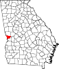
Unincorporated
communitiesBibb City | Columbus City | Custer Terrace | Fortson | Midland | Upatoi
MB Greater Columbus, Georgia Central cities/Largest cities  Location of the Columbus, Georgia-Auburn, Alabama CSA and its counties:
 Columbus, Georgia Metropolitan Statistical AreaAuburn, Alabama Metropolitan Statistical AreaTuskegee, Alabama Micropolitan Statistical Area
Cities in Georgia Bibb City · Buena Vista · Cataula · Columbus · Cusseta · Custer Terrace · Fort Benning South · Fortson · Hamilton · Hopewell · Juniper · Midland · Mountain Hill · Mulberry Grove · Pine Mountain · Rehobeth · Ridgeway · Shiloh · Upatoi · Waverly Hall · West Point · WhitesvilleCities in Alabama Beauregard · Bee Hive · Beulah · Creek Stand · Fort Mitchell · Franklin · Glenville · Gold Hill · Holy Trinity · Hurtsboro · Ladonia · Loachapoka · Marvyn · Notasulga · Opelika · Phenix City · Roxana · Salem · Seale · Shorter · Smiths Station · The Bottle · Tuskegee · WaverlyCounties in Georgia Counties in Alabama Categories:- Georgia (U.S. state) counties
- Muscogee County, Georgia
- 1826 establishments in the United States
- Populated places established in 1826
- Columbus, Georgia metropolitan area
- Geography of Columbus, Georgia


Wikimedia Foundation. 2010.