- Cusseta, Georgia
-
Cusseta, Georgia — City — Location in Chattahoochee County and the state of Georgia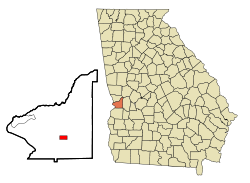
Coordinates: 32°18′20″N 84°46′37″W / 32.30556°N 84.77694°WCoordinates: 32°18′20″N 84°46′37″W / 32.30556°N 84.77694°W Country United States State Georgia County Chattahoochee Area – Total 1.5 sq mi (3.9 km2) – Land 1.5 sq mi (3.9 km2) – Water 0 sq mi (0 km2) Population (2000) – Total 1,196 – Density 797.3/sq mi (306.7/km2) Time zone Eastern (EST) (UTC-5) – Summer (DST) EDT (UTC-4) ZIP code 31805 Area code(s) 706 FIPS code 13-21016[1] Cusseta-Chattahoochee County is unified city-county in Georgia, United States. It is part of the Columbus, Georgia-Alabama Metropolitan Statistical Area. The population was 1,196 at the 2000 Census.[2].
Contents
History
The history of Cusseta begins with the creation of Chattahoochee County, Georgia by an act of the Georgia General Assembly on February 13, 1854. The county was formed from portions of Muscogee and Marion counties and named for the river that forms its western boundary. The act appointed five commissioners to choose a site for the county seat, which they named Cusseta to commemorate the Creek Indian town that used to exist nearby.
The original courthouse, built in 1854 by slaves, is preserved at the tourist attraction of Westville, near Lumpkin, Georgia.
Cusseta was incorporated as a city on December 22, 1855. It is still the only incorporated city in Chattahoochee County.
Cusseta briefly prided itself on having the world's tallest man-made structure, the WTVM/WRBL-TV & WVRK-FM Tower, a guyed transmission tower built in 1962 about one mile from the city. However, it was surpassed only one year later by the KVLY-TV mast in Fargo, North Dakota.
In 2003 the city and county formed a consolidated Cusseta-Chattahoochee County government.
Geography
Cusseta is located at 32°18′20″N 84°46′37″W / 32.30556°N 84.77694°W (32.305451, -84.776929)[3].
According to the United States Census Bureau, the city has a total area of 1.5 square miles (3.9 km2), of which, 1.5 square miles (3.9 km2) of it is land and 0.66% is water.
Demographics
As of the census[1] of 2000, there were 1,196 people, 436 households, and 316 families residing in the city. The population density was 787.8 people per square mile (303.8/km²). There were 543 housing units at an average density of 357.7 per square mile (137.9/km²). The racial makeup of the city was 60.54% White, 36.45% African American, 0.42% Native American, 0.08% Asian, 0.33% Pacific Islander, 0.50% from other races, and 1.67% from two or more races. Hispanic or Latino of any race were 1.67% of the population.
There were 436 households out of which 37.2% had children under the age of 18 living with them, 45.4% were married couples living together, 20.9% had a female householder with no husband present, and 27.3% were non-families. 22.0% of all households were made up of individuals and 7.3% had someone living alone who was 65 years of age or older. The average household size was 2.74 and the average family size was 3.19.
In the city the population was spread out with 32.2% under the age of 18, 9.7% from 18 to 24, 30.4% from 25 to 44, 18.8% from 45 to 64, and 8.9% who were 65 years of age or older. The median age was 32 years. For every 100 females there were 99.7 males. For every 100 females age 18 and over, there were 93.6 males.
The median income for a household in the city was $25,625, and the median income for a family was $26,736. Males had a median income of $25,380 versus $19,205 for females. The per capita income for the city was $14,115. About 25.8% of families and 28.8% of the population were below the poverty line, including 37.0% of those under age 18 and 27.3% of those age 65 or over.
Education
Chattahoochee County School District
The Chattahoochee County School District holds grades pre-school to grade twelve, that consists of one elementary school, a middle school and a high school.[4] The district has 34 full-time teachers and over 451 students.[5]
- Chattahoochee County Education Center
- Chattahoochee County Middle School
- Chattahoochee County High School
See also
References
- ^ a b "American FactFinder". United States Census Bureau. http://factfinder.census.gov. Retrieved 2008-01-31.
- ^ "Find a County". National Association of Counties. http://www.naco.org/Counties/Pages/FindACounty.aspx. Retrieved 2011-06-07.
- ^ "US Gazetteer files: 2010, 2000, and 1990". United States Census Bureau. 2011-02-12. http://www.census.gov/geo/www/gazetteer/gazette.html. Retrieved 2011-04-23.
- ^ Georgia Board of Education, Retrieved June 3, 2010.
- ^ School Stats, Retrieved June 3, 2010.
External links
- City of Cusseta at georgia.gov
- Official website of the Unified Government of Cusseta-Chattahoochee County
Greater Columbus, Georgia Central cities/Largest cities  Location of the Columbus, Georgia-Auburn, Alabama CSA and its counties:
 Columbus, Georgia Metropolitan Statistical AreaAuburn, Alabama Metropolitan Statistical AreaTuskegee, Alabama Micropolitan Statistical Area
Cities in Georgia Bibb City · Buena Vista · Cataula · Columbus · Cusseta · Custer Terrace · Fort Benning South · Fortson · Hamilton · Hopewell · Juniper · Midland · Mountain Hill · Mulberry Grove · Pine Mountain · Rehobeth · Ridgeway · Shiloh · Upatoi · Waverly Hall · West Point · WhitesvilleCities in Alabama Beauregard · Bee Hive · Beulah · Creek Stand · Fort Mitchell · Franklin · Glenville · Gold Hill · Holy Trinity · Hurtsboro · Ladonia · Loachapoka · Marvyn · Notasulga · Opelika · Phenix City · Roxana · Salem · Seale · Shorter · Smiths Station · The Bottle · Tuskegee · WaverlyCounties in Georgia Counties in Alabama Categories:- Cities in Georgia (U.S. state)
- Populated places in Chattahoochee County, Georgia
- County seats in Georgia (U.S. state)
- Columbus, Georgia metropolitan area

Wikimedia Foundation. 2010.